Property Record
1533 Nw 36Th St, Newton, KS 67114
NEARBY LISTINGS FOR SALE OR LEASE
-
-
View all Newton listings for sale on LoopNet.com
Property Detail
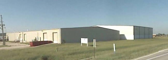
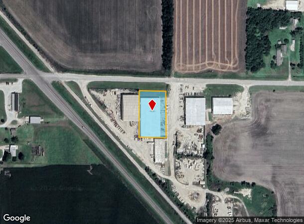
1533 Nw 36Th St
Wichita, KS
Schmidt Industrial Park
093-06-0-20-03-001.01-0
SCHMIDT INDUSTRIAL PARK, S06, T23, R01E, BLOCK C, LOT 1 - 2, ACRES 1.1
Warehouse
Harvey
X
Kansas
20079C0203E
1,2
2024
1.09 AC
2025
Newton/Hesston
030400
Wichita
28,800 SF
DEMOGRAPHICS near 1533 Nw 36Th St
1 Mile
3 Mile
5 Mile
2024 Total Population
1,328
12,485
21,844
2029 Population
1,323
12,433
21,735
Pop Growth 2024-2029
(0.38%)
(0.42%)
(0.50%)
Average Age
47
42
41
2024 Total Households
510
5,039
8,730
HH Growth 2024-2029
(0.39%)
(0.50%)
(0.57%)
Median Household Inc
$82,954
$58,375
$61,113
Avg Household Size
2.10
2.30
2.40
2024 Avg HH Vehicles
2.00
2.00
2.00
Median Home Value
$187,670
$123,660
$130,526
Median Year Built
1985
1961
1965
Nearby Places
- Restaurants
- Banks
- Shops
- Fitness
- Groceries
PUBLIC TRANSPORTATION
COMMUTER RAIL
Newton (Southwest Chief - Amtrak)
DRIVE
WALK
Distance
Newton (Southwest Chief - Amtrak)
6 min
3.5 mi
Freight Ports
Tulsa Port Of Catoosa
DRIVE
WALK
Distance
Tulsa Port Of Catoosa
238 min
222.0 mi
Nearby Properties
Address
Land Use
TOTAL SIZE
Lot Size
Zoning
Address
Land Use
TOTAL SIZE
Lot Size
Zoning
216,365 SF
56.60 AC
Address
Land Use
TOTAL SIZE
Lot Size
Zoning
33,598 SF
4 AC
Address
Land Use
TOTAL SIZE
Lot Size
Zoning
61,740 SF
2.39 AC
Address
Land Use
TOTAL SIZE
Lot Size
Zoning
52,180 SF
6.20 AC
R1
Address
Land Use
TOTAL SIZE
Lot Size
Zoning
49,644 SF
10.60 AC
R1
Address
Land Use
TOTAL SIZE
Lot Size
Zoning
17,253 SF
2.30 AC
PO
Address
Land Use
TOTAL SIZE
Lot Size
Zoning
30,693 SF
29 AC
PO
Address
Land Use
TOTAL SIZE
Lot Size
Zoning
64,131 SF
1.60 AC
PO
Address
Land Use
TOTAL SIZE
Lot Size
Zoning
27,268 SF
4.90 AC
Address
Land Use
TOTAL SIZE
Lot Size
Zoning
22,491 SF
1.36 AC
Address
Land Use
TOTAL SIZE
Lot Size
Zoning
16,735 SF
7.10 AC
R1
Address
Land Use
TOTAL SIZE
Lot Size
Zoning
29,115 SF
0.60 AC
Address
Land Use
TOTAL SIZE
Lot Size
Zoning
42,160 SF
0.92 AC
PO
Address
Land Use
TOTAL SIZE
Lot Size
Zoning
18,431 SF
1.10 AC
Address
Land Use
TOTAL SIZE
Lot Size
Zoning
13,140 SF
1.50 AC
R3
Address
Land Use
TOTAL SIZE
Lot Size
Zoning
20,122 SF
7.55 AC
PO
Address
Land Use
TOTAL SIZE
Lot Size
Zoning
36,270 SF
0.77 AC
Address
Land Use
TOTAL SIZE
Lot Size
Zoning
18,214 SF
0.25 AC
Address
Land Use
TOTAL SIZE
Lot Size
Zoning
7,569 SF
2.70 AC
Address
Land Use
TOTAL SIZE
Lot Size
Zoning
34,922 SF
3.70 AC
C3
Address
Land Use
TOTAL SIZE
Lot Size
Zoning
15,194 SF
1.40 AC
Address
Land Use
TOTAL SIZE
Lot Size
Zoning
17,489 SF
1.40 AC
R1
Address
Land Use
TOTAL SIZE
Lot Size
Zoning
15.10 AC
Address
Land Use
TOTAL SIZE
Lot Size
Zoning
17,488 SF
1.85 AC
Address
Land Use
TOTAL SIZE
Lot Size
Zoning
27,192 SF
3.90 AC
Address
Land Use
TOTAL SIZE
Lot Size
Zoning
14,254 SF
1.70 AC
R1
Address
Land Use
TOTAL SIZE
Lot Size
Zoning
11,175 SF
4.60 AC
Address
Land Use
TOTAL SIZE
Lot Size
Zoning
5.54 AC
Address
Land Use
TOTAL SIZE
Lot Size
Zoning
12,362 SF
3.70 AC
Address
Land Use
TOTAL SIZE
Lot Size
Zoning
12,191 SF
1.20 AC
The World's #1 Commercial Real Estate Marketplace
Connect with us
© 2025 CoStar Group
The information above has been obtained from sources believed reliable. While we do not doubt its accuracy we have not verified it and make no guarantee, warranty or representation about it. It is your responsibility to independently confirm its accuracy and completeness. Any projections, opinions, assumptions, or estimates used are for example only and do not represent the current or future performance of the property. The value of this transaction to you depends on tax and other factors which should be evaluated by your tax, financial, and legal advisors. You and your advisors should conduct a careful, independent investigation of the property to determine to your satisfaction the suitability of the property for your needs.