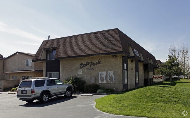
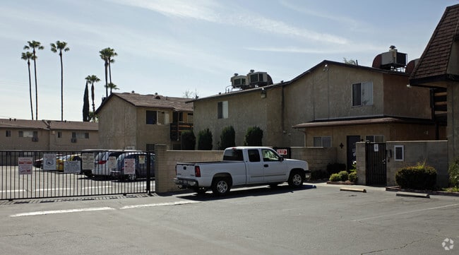
Property Record
1535 E Date St, San Bernardino, CA 92404


NEARBY LISTINGS FOR SALE OR LEASE
Property Detail
1535 E Date St
Riverside-San Bernardino-Ontario, CA
Orange Grove Tr
0272-192-09
ORANGE GROVE TR E 1/2 N 1/2 LOT 5 BLK 13 AND S 11.25 FT ST CLOSED ADJ ON N EX S 200 FT THEREOF AND EX N 3 FT ST 1.38 AC M/L
Apartment
San Bernardino
X
California
06071C7944H
5
2024
1.34 AC
2025
Northeast Sterling
006204
Inland Empire (California)
27,644 SF
DEMOGRAPHICS near 1535 E Date St
1 Mile
3 Mile
5 Mile
2024 Total Population
27,002
155,139
250,267
2029 Population
27,532
157,792
254,166
Pop Growth 2024-2029
+ 1.96%
+ 1.71%
+ 1.56%
Average Age
33
34
35
2024 Total Households
7,652
44,388
71,599
HH Growth 2024-2029
+ 2.06%
+ 1.76%
+ 1.64%
Median Household Inc
$56,779
$55,468
$58,871
Avg Household Size
3.40
3.30
3.30
2024 Avg HH Vehicles
2.00
2.00
2.00
Median Home Value
$329,075
$331,987
$342,350
Median Year Built
1966
1964
1967
Nearby Places
Map Layers
Map Styles
 Street
 Aerial
- Restaurants
- Banks
- Shops
- Fitness
- Groceries
PUBLIC TRANSPORTATION
COMMUTER RAIL
DRIVE
WALK
Distance
11 min
5.4 mi
San Bernardino (Inland Empire-Orange County Line - Southern California Regional Rail Authority (Metrolink), San Bernardino Line - Southern California Regional Rail Authority (Metrolink))
DRIVE
WALK
Distance
San Bernardino (Inland Empire-Orange County Line - Southern California Regional Rail Authority (Metrolink), San Bernardino Line - Southern California Regional Rail Authority (Metrolink))
10 min
6.5 mi
AIRPORT
Ontario International
DRIVE
WALK
Distance
Ontario International
34 min
24.3 mi
SALE & LEASE HISTORY
LISTING DATE
SALE/LEASE

Dec 14, 2018
For Sale
Nearby Properties
Address
Land Use
TOTAL SIZE
Lot Size
Zoning
Address
Land Use
TOTAL SIZE
Lot Size
Zoning
708,500 SF
97.74 AC
Address
Land Use
TOTAL SIZE
Lot Size
Zoning
778,653 SF
19.31 AC
Address
Land Use
TOTAL SIZE
Lot Size
Zoning
406,710 SF
20.10 AC
Address
Land Use
TOTAL SIZE
Lot Size
Zoning
1,205,400 SF
58.05 AC
Address
Land Use
TOTAL SIZE
Lot Size
Zoning
178,926 SF
9.12 AC
IC
Address
Land Use
TOTAL SIZE
Lot Size
Zoning
335,000 SF
8.44 AC
Address
Land Use
TOTAL SIZE
Lot Size
Zoning
415,405 SF
18.43 AC
IC
Address
Land Use
TOTAL SIZE
Lot Size
Zoning
599,690 SF
17.08 AC
IC
Address
Land Use
TOTAL SIZE
Lot Size
Zoning
159,956 SF
9.20 AC
Address
Land Use
TOTAL SIZE
Lot Size
Zoning
350,939 SF
6.29 AC
Address
Land Use
TOTAL SIZE
Lot Size
Zoning
150,308 SF
6.75 AC
Address
Land Use
TOTAL SIZE
Lot Size
Zoning
155,309 SF
5.56 AC
Address
Land Use
TOTAL SIZE
Lot Size
Zoning
Address
Land Use
TOTAL SIZE
Lot Size
Zoning
8,200 SF
11.29 AC
Address
Land Use
TOTAL SIZE
Lot Size
Zoning
112,520 SF
8.80 AC
Address
Land Use
TOTAL SIZE
Lot Size
Zoning
156,367 SF
7.40 AC
Address
Land Use
TOTAL SIZE
Lot Size
Zoning
132,596 SF
7.35 AC
Address
Land Use
TOTAL SIZE
Lot Size
Zoning
70,386 SF
5.11 AC
Address
Land Use
TOTAL SIZE
Lot Size
Zoning
954 SF
9.34 AC
IC
Address
Land Use
TOTAL SIZE
Lot Size
Zoning
148,639 SF
12.12 AC
Address
Land Use
TOTAL SIZE
Lot Size
Zoning
73,864 SF
5.44 AC
R1
Address
Land Use
TOTAL SIZE
Lot Size
Zoning
212,970 SF
11.05 AC
Address
Land Use
TOTAL SIZE
Lot Size
Zoning
73,308 SF
4.76 AC
Address
Land Use
TOTAL SIZE
Lot Size
Zoning
134,140 SF
8.27 AC
Address
Land Use
TOTAL SIZE
Lot Size
Zoning
87,733 SF
4.65 AC
Address
Land Use
TOTAL SIZE
Lot Size
Zoning
66,180 SF
3.07 AC
Address
Land Use
TOTAL SIZE
Lot Size
Zoning
129,968 SF
7.11 AC
Address
Land Use
TOTAL SIZE
Lot Size
Zoning
91,086 SF
4.16 AC
Address
Land Use
TOTAL SIZE
Lot Size
Zoning
127,420 SF
7.20 AC
Address
Land Use
TOTAL SIZE
Lot Size
Zoning
38,150 SF
4.18 AC
The World's #1 Commercial Real Estate Marketplace
Connect with us
© 2025 CoStar Group
The information above has been obtained from sources believed reliable. While we do not doubt its accuracy we have not verified it and make no guarantee, warranty or representation about it. It is your responsibility to independently confirm its accuracy and completeness. Any projections, opinions, assumptions, or estimates used are for example only and do not represent the current or future performance of the property. The value of this transaction to you depends on tax and other factors which should be evaluated by your tax, financial, and legal advisors. You and your advisors should conduct a careful, independent investigation of the property to determine to your satisfaction the suitability of the property for your needs.