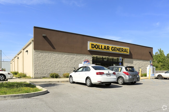
Property Record
1535 Madison Ave, Painesville, OH 44077


NEARBY LISTINGS FOR SALE OR LEASE
Property Detail
1535 Madison Ave
11-A-024-0-00-031
LOT 30 TRACT 1
Storebuilding
Lake
X
Ohio
39085C0127F
30
0
1.38 AC
2024
Northeast
204900
Cleveland
9,091 SF
Cleveland-Elyria, OH
DEMOGRAPHICS near 1535 Madison Ave
1 Mile
3 Mile
5 Mile
2024 Total Population
4,244
24,430
56,540
2029 Population
4,219
24,373
56,484
Pop Growth 2024-2029
(0.59%)
(0.23%)
(0.10%)
Average Age
43
41
41
2024 Total Households
1,639
9,527
22,459
HH Growth 2024-2029
(0.67%)
(0.24%)
(0.14%)
Median Household Inc
$97,400
$68,949
$74,906
Avg Household Size
2.50
2.40
2.40
2024 Avg HH Vehicles
2.00
2.00
2.00
Median Home Value
$196,282
$171,211
$185,120
Median Year Built
1977
1974
1975
Nearby Places
Map Layers
Map Styles
 Street
 Aerial
- Restaurants
- Banks
- Shops
- Fitness
- Groceries
SALE & LEASE HISTORY
LISTING DATE
SALE/LEASE

Sep 24, 2016
For Sale
Nearby Properties
Address
Land Use
TOTAL SIZE
Lot Size
Zoning
Address
Land Use
TOTAL SIZE
Lot Size
Zoning
160,976 SF
3.31 AC
B-4
Address
Land Use
TOTAL SIZE
Lot Size
Zoning
165,749 SF
8 AC
R-1
Address
Land Use
TOTAL SIZE
Lot Size
Zoning
243,207 SF
43.47 AC
R-3
Address
Land Use
TOTAL SIZE
Lot Size
Zoning
78,850 SF
Address
Land Use
TOTAL SIZE
Lot Size
Zoning
197,433 SF
26.82 AC
R-1
Address
Land Use
TOTAL SIZE
Lot Size
Zoning
113,375 SF
2.73 AC
B-3
Address
Land Use
TOTAL SIZE
Lot Size
Zoning
82,044 SF
8.79 AC
Address
Land Use
TOTAL SIZE
Lot Size
Zoning
137,183 SF
12.35 AC
Address
Land Use
TOTAL SIZE
Lot Size
Zoning
51,672 SF
Address
Land Use
TOTAL SIZE
Lot Size
Zoning
47,436 SF
16.83 AC
R1
Address
Land Use
TOTAL SIZE
Lot Size
Zoning
Address
Land Use
TOTAL SIZE
Lot Size
Zoning
50,644 SF
250.64 AC
I-2
Address
Land Use
TOTAL SIZE
Lot Size
Zoning
8,556 SF
74.61 AC
R-1
Address
Land Use
TOTAL SIZE
Lot Size
Zoning
74,502 SF
6.35 AC
R-1
Address
Land Use
TOTAL SIZE
Lot Size
Zoning
47,934 SF
0.73 AC
B-4
Address
Land Use
TOTAL SIZE
Lot Size
Zoning
142,393 SF
11.81 AC
Address
Land Use
TOTAL SIZE
Lot Size
Zoning
75,593 SF
2.49 AC
B-3
Address
Land Use
TOTAL SIZE
Lot Size
Zoning
50,908 SF
71.84 AC
I-2
Address
Land Use
TOTAL SIZE
Lot Size
Zoning
227,951 SF
66.34 AC
I-1
Address
Land Use
TOTAL SIZE
Lot Size
Zoning
100,142 SF
25.07 AC
Address
Land Use
TOTAL SIZE
Lot Size
Zoning
62,554 SF
3.26 AC
R-1
Address
Land Use
TOTAL SIZE
Lot Size
Zoning
79,825 SF
9.28 AC
R-1
Address
Land Use
TOTAL SIZE
Lot Size
Zoning
56,688 SF
6.78 AC
Address
Land Use
TOTAL SIZE
Lot Size
Zoning
179,065 SF
28.69 AC
I2
Address
Land Use
TOTAL SIZE
Lot Size
Zoning
2,000 SF
224.82 AC
R
Address
Land Use
TOTAL SIZE
Lot Size
Zoning
50,580 SF
7.26 AC
B
Address
Land Use
TOTAL SIZE
Lot Size
Zoning
100,396 SF
14.97 AC
M-1
Address
Land Use
TOTAL SIZE
Lot Size
Zoning
59,922 SF
10.21 AC
Address
Land Use
TOTAL SIZE
Lot Size
Zoning
212,360 SF
4.45 AC
M-2
Address
Land Use
TOTAL SIZE
Lot Size
Zoning
233.79 AC
R-1
The World's #1 Commercial Real Estate Marketplace
Connect with us
© 2025 CoStar Group
The information above has been obtained from sources believed reliable. While we do not doubt its accuracy we have not verified it and make no guarantee, warranty or representation about it. It is your responsibility to independently confirm its accuracy and completeness. Any projections, opinions, assumptions, or estimates used are for example only and do not represent the current or future performance of the property. The value of this transaction to you depends on tax and other factors which should be evaluated by your tax, financial, and legal advisors. You and your advisors should conduct a careful, independent investigation of the property to determine to your satisfaction the suitability of the property for your needs.