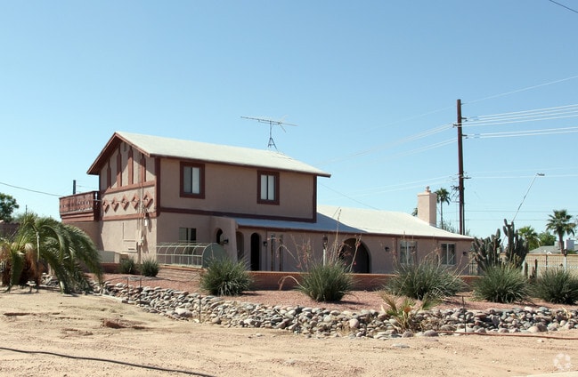
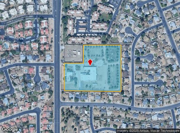
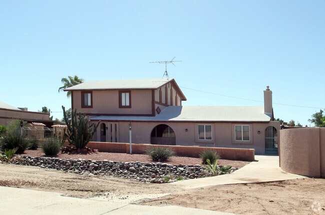
Property Record
1535 N Dobson Rd, Chandler, AZ 85224
NEARBY LISTINGS FOR SALE OR LEASE
Property Detail
1535 N Dobson Rd
Phoenix-Mesa-Chandler, AZ
Wayne
302-83-965
WAYNE MCR 1842-36
Commercialnec
Maricopa
X
Arizona
04013C2710L
1a
2025
6.33 AC
2025
Chandler
523005
Phoenix
22,149 SF
DEMOGRAPHICS near 1535 N Dobson Rd
1 mile
3 mile
5 mile
2024 Total Population
16,421
134,286
338,711
2029 Population
17,593
144,370
364,666
Pop Growth 2024-2029
+ 7.14%
+ 7.51%
+ 7.66%
Average Age
39
38
38
2024 Total Households
6,568
52,495
131,984
HH Growth 2024-2029
+ 7.20%
+ 7.60%
+ 7.76%
Median Household Inc
$87,338
$84,128
$85,117
Avg Household Size
2.50
2.50
2.50
2024 Avg HH Vehicles
2.00
2.00
2.00
Median Home Value
$351,960
$362,469
$385,266
Median Year Built
1986
1987
1988
Nearby Places
Map Layers
Map Styles
 Street
 Aerial
Transit
 Traffic
 Biking
Places
Listings with unknown addresses are not visible on the map
- Restaurants
- Banks
- Shops
- Fitness
- Groceries
PUBLIC TRANSPORTATION
AIRPORT
Phoenix-Mesa Gateway
Drive
Walk
Distance
Phoenix-Mesa Gateway
26 min
13.6 mi
Phoenix Sky Harbor International
Drive
Walk
Distance
Phoenix Sky Harbor International
22 min
15.1 mi
Freight Ports
Port of San Diego
Drive
Walk
Distance
Port of San Diego
401 min
365.0 mi
Nearby Properties
Address
Land Use
TOTAL SIZE
Lot Size
Zoning
Address
Land Use
TOTAL SIZE
Lot Size
Zoning
221,091 SF
14.76 AC
I-1
Address
Land Use
TOTAL SIZE
Lot Size
Zoning
136,458 SF
7.85 AC
PAD
Address
Land Use
TOTAL SIZE
Lot Size
Zoning
128,194 SF
8.58 AC
PAD
Address
Land Use
TOTAL SIZE
Lot Size
Zoning
733,019 SF
13.13 AC
PAD
Address
Land Use
TOTAL SIZE
Lot Size
Zoning
1,418,890 SF
39 AC
PF
Address
Land Use
TOTAL SIZE
Lot Size
Zoning
1.13 AC
Address
Land Use
TOTAL SIZE
Lot Size
Zoning
724,125 SF
39.23 AC
Address
Land Use
TOTAL SIZE
Lot Size
Zoning
774,482 SF
25.50 AC
PAD
Address
Land Use
TOTAL SIZE
Lot Size
Zoning
860,343 SF
56.83 AC
I-1
Address
Land Use
TOTAL SIZE
Lot Size
Zoning
2.57 AC
Address
Land Use
TOTAL SIZE
Lot Size
Zoning
301,190 SF
77.17 AC
PF
Address
Land Use
TOTAL SIZE
Lot Size
Zoning
984,487 SF
37.54 AC
I-1
Address
Land Use
TOTAL SIZE
Lot Size
Zoning
15,066 SF
2.54 AC
PAD
Address
Land Use
TOTAL SIZE
Lot Size
Zoning
607,734 SF
17.89 AC
AG
Address
Land Use
TOTAL SIZE
Lot Size
Zoning
416,954 SF
9.59 AC
PF
Address
Land Use
TOTAL SIZE
Lot Size
Zoning
395,055 SF
8.33 AC
PAD
Address
Land Use
TOTAL SIZE
Lot Size
Zoning
269,504 SF
8.87 AC
I-1
Address
Land Use
TOTAL SIZE
Lot Size
Zoning
393,258 SF
49.79 AC
AG
Address
Land Use
TOTAL SIZE
Lot Size
Zoning
177,897 SF
17.81 AC
AG
Address
Land Use
TOTAL SIZE
Lot Size
Zoning
403,326 SF
8.71 AC
PAD
Address
Land Use
TOTAL SIZE
Lot Size
Zoning
249,019 SF
23.96 AC
AG
Address
Land Use
TOTAL SIZE
Lot Size
Zoning
444,802 SF
4.17 AC
I-1
Address
Land Use
TOTAL SIZE
Lot Size
Zoning
175,866 SF
12.46 AC
AG
Address
Land Use
TOTAL SIZE
Lot Size
Zoning
301,597 SF
10.79 AC
PAD
Address
Land Use
TOTAL SIZE
Lot Size
Zoning
244,900 SF
38.47 AC
PF
Address
Land Use
TOTAL SIZE
Lot Size
Zoning
379,460 SF
11.40 AC
PAD
Address
Land Use
TOTAL SIZE
Lot Size
Zoning
313,144 SF
8.62 AC
PAD
Address
Land Use
TOTAL SIZE
Lot Size
Zoning
348,379 SF
6.49 AC
PAD
Address
Land Use
TOTAL SIZE
Lot Size
Zoning
214,126 SF
11.42 AC
The World's #1 Commercial Real Estate Marketplace
Connect with us
© 2026 CoStar Group
The information above has been obtained from sources believed reliable. While we do not doubt its accuracy we have not verified it and make no guarantee, warranty or representation about it. It is your responsibility to independently confirm its accuracy and completeness. Any projections, opinions, assumptions, or estimates used are for example only and do not represent the current or future performance of the property. The value of this transaction to you depends on tax and other factors which should be evaluated by your tax, financial, and legal advisors. You and your advisors should conduct a careful, independent investigation of the property to determine to your satisfaction the suitability of the property for your needs.