Property Record
1535 Pensacola St, Honolulu, HI 96822
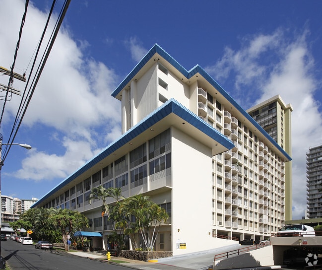
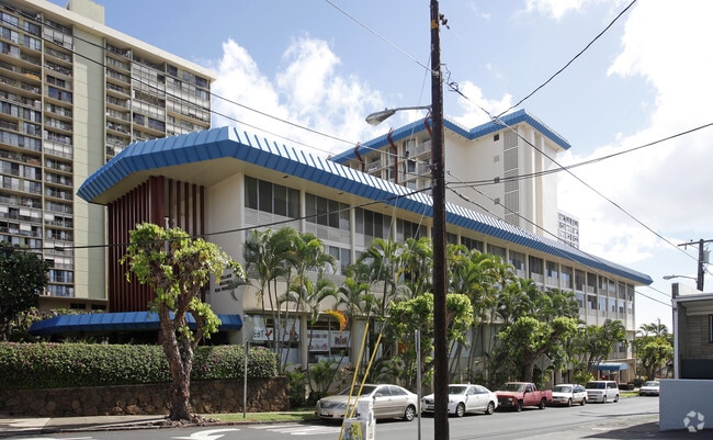
This Property Is For Sale
Current Lease Availabilities
NEARBY LISTINGS FOR SALE OR LEASE
-
-
-
-
-
-
-
-
-
-
-
-
-
2139 Kuhio Ave. 27TH and 34th Floor
Honolulu, HI 96815
$10,235,000 - $13,650,000
6,992 - 7,293 SF
Multifamily
-
-
-
-
-
-
View all Honolulu listings for lease on LoopNet.com
Property Detail
1535 Pensacola St
Urban Honolulu, HI
The Village Maluhia
1-2-4-019-010-0136
APT C-6 THE VILLAGE MALUHIA CONDO MAP 648 TOG W/PARKING STALL(S) 3 & 6 UND .55% INT IN ALL COMMON ELEMENTS
Commercialnec
Honolulu
X
Hawaii
15003C0362G
10
2024
1.11 AC
2025
Makiki-Lower Punchbowl-Tantalu
003408
Hawaii
488 SF
DEMOGRAPHICS near 1535 Pensacola St
1 Mile
3 Mile
5 Mile
2024 Total Population
68,163
259,003
344,427
2029 Population
67,675
257,208
340,193
Pop Growth 2024-2029
(0.72%)
(0.69%)
(1.23%)
Average Age
45
45
44
2024 Total Households
32,561
111,813
138,504
HH Growth 2024-2029
(1.32%)
(0.66%)
(1.16%)
Median Household Inc
$70,827
$70,706
$75,500
Avg Household Size
2.00
2.10
2.30
2024 Avg HH Vehicles
1.00
1.00
1.00
Median Home Value
$642,329
$724,104
$793,031
Median Year Built
1975
1974
1972
Nearby Places
- Restaurants
- Banks
- Shops
- Fitness
- Groceries
PUBLIC TRANSPORTATION
AIRPORT
Daniel K Inouye International
DRIVE
WALK
Distance
Daniel K Inouye International
13 min
6.9 mi
Freight Ports
Honolulu Harbor, Oahu
DRIVE
WALK
Distance
Honolulu Harbor, Oahu
15 min
6.7 mi
Nearby Properties
Address
Land Use
TOTAL SIZE
Lot Size
Zoning
Address
Land Use
TOTAL SIZE
Lot Size
Zoning
7,944,732 SF
34.93 AC
BMX-3
Address
Land Use
TOTAL SIZE
Lot Size
Zoning
119.90 AC
U/X7/60
Address
Land Use
TOTAL SIZE
Lot Size
Zoning
492,607 SF
9.06 AC
ResMix
Address
Land Use
TOTAL SIZE
Lot Size
Zoning
264,870 SF
3.47 AC
ResMix
Address
Land Use
TOTAL SIZE
Lot Size
Zoning
13,088 SF
75.21 AC
P-2
Address
Land Use
TOTAL SIZE
Lot Size
Zoning
193,478 SF
10.34 AC
ResMix
Address
Land Use
TOTAL SIZE
Lot Size
Zoning
1,100,000 SF
9.65 AC
BMX-3
Address
Land Use
TOTAL SIZE
Lot Size
Zoning
292,691 SF
1.09 AC
ResMix
Address
Land Use
TOTAL SIZE
Lot Size
Zoning
55.93 AC
WI
Address
Land Use
TOTAL SIZE
Lot Size
Zoning
164,234 SF
2.56 AC
ResMix
Address
Land Use
TOTAL SIZE
Lot Size
Zoning
495,002 SF
2.42 AC
ResMix
Address
Land Use
TOTAL SIZE
Lot Size
Zoning
1,153,381 SF
425.42 AC
R-5
Address
Land Use
TOTAL SIZE
Lot Size
Zoning
476,537 SF
6.31 AC
ResMix
Address
Land Use
TOTAL SIZE
Lot Size
Zoning
130,002 SF
2.50 AC
ResMix
Address
Land Use
TOTAL SIZE
Lot Size
Zoning
45.65 AC
Kak
Address
Land Use
TOTAL SIZE
Lot Size
Zoning
42.67 AC
P-2
Address
Land Use
TOTAL SIZE
Lot Size
Zoning
1,599,500 SF
7.27 AC
BMX-3
Address
Land Use
TOTAL SIZE
Lot Size
Zoning
107,721 SF
2.76 AC
ResMix
Address
Land Use
TOTAL SIZE
Lot Size
Zoning
2.32 AC
Kak
Address
Land Use
TOTAL SIZE
Lot Size
Zoning
103,284 SF
1.84 AC
ResMix
Address
Land Use
TOTAL SIZE
Lot Size
Zoning
254,832 SF
2.92 AC
BMX-4
Address
Land Use
TOTAL SIZE
Lot Size
Zoning
242,241 SF
2.40 AC
ResMix
Address
Land Use
TOTAL SIZE
Lot Size
Zoning
64,300 SF
0.77 AC
ResMix
Address
Land Use
TOTAL SIZE
Lot Size
Zoning
104,386 SF
1.04 AC
ResMix
Address
Land Use
TOTAL SIZE
Lot Size
Zoning
172,305 SF
2.54 AC
ResMix
Address
Land Use
TOTAL SIZE
Lot Size
Zoning
144,855 SF
1.74 AC
ResMix
Address
Land Use
TOTAL SIZE
Lot Size
Zoning
1.13 AC
ResMix
Address
Land Use
TOTAL SIZE
Lot Size
Zoning
12,430 SF
86.69 AC
I-3
Address
Land Use
TOTAL SIZE
Lot Size
Zoning
9,272 SF
141.38 AC
P-2
Address
Land Use
TOTAL SIZE
Lot Size
Zoning
1,618,933 SF
1.77 AC
ResMix
The World's #1 Commercial Real Estate Marketplace
Connect with us
© 2025 CoStar Group
The information above has been obtained from sources believed reliable. While we do not doubt its accuracy we have not verified it and make no guarantee, warranty or representation about it. It is your responsibility to independently confirm its accuracy and completeness. Any projections, opinions, assumptions, or estimates used are for example only and do not represent the current or future performance of the property. The value of this transaction to you depends on tax and other factors which should be evaluated by your tax, financial, and legal advisors. You and your advisors should conduct a careful, independent investigation of the property to determine to your satisfaction the suitability of the property for your needs.