Property Record
1535 W Hamilton Ave, Eau Claire, WI 54701


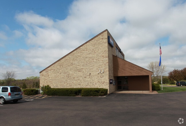
Property Detail
1535 W Hamilton Ave
15-2835
A PC OF LAND IN GOV LOT 5 SEC 36-27-10 & IN NW 1/4-NW 1/4 SEC 31-27-9 DESCR AS FOLL BEG AT INTSEC OF E LN OF H/W 37 & S LN OF
Officebuilding
Eau Claire
C2
Wisconsin
B and X Area of moderate flood hazard, usually the area between the limits of the 100-year and 500-year floods.
5
2025
2.16 AC
2025
Eau Claire/Menomonie
000900
Other Market Areas
4,200 SF
Eau Claire, WI
NEARBY LISTINGS FOR SALE OR LEASE
DEMOGRAPHICS near 1535 W Hamilton Ave
1 mile
3 mile
5 mile
2025 Total Population
3,407
39,974
77,623
2030 Population
3,490
40,850
79,789
Pop Growth 2025-2030
+ 2.44%
+ 2.19%
+ 2.79%
Average Age
38
36
38
2025 Total Households
1,604
15,977
32,234
HH Growth 2025-2030
+ 2.74%
+ 2.42%
+ 2.95%
Median Household Inc
$57,940
$65,986
$70,317
Avg Household Size
2.10
2.20
2.20
2025 Avg HH Vehicles
1.00
2.00
2.00
Median Home Value
$317,660
$259,579
$258,285
Median Year Built
1987
1971
1977
Nearby Places
Map Layers
Map Styles
 Street
 Aerial
Layers
 Traffic
 Biking
Places
Listings with unknown addresses are not visible on the map
- Restaurants
- Banks
- Shops
- Fitness
- Groceries
SALE & LEASE HISTORY
LISTING DATE
SALE/LEASE

Mar 20, 2023
For Sale
Nearby Properties
Address
Land Use
TOTAL SIZE
Lot Size
Zoning
Address
Land Use
TOTAL SIZE
Lot Size
Zoning
203,723 SF
Address
Land Use
TOTAL SIZE
Lot Size
Zoning
97,194 SF
7.39 AC
C3H
Address
Land Use
TOTAL SIZE
Lot Size
Zoning
361,759 SF
8.46 AC
Address
Land Use
TOTAL SIZE
Lot Size
Zoning
206,042 SF
5.59 AC
Address
Land Use
TOTAL SIZE
Lot Size
Zoning
0.78 AC
Address
Land Use
TOTAL SIZE
Lot Size
Zoning
1.36 AC
CBD
Address
Land Use
TOTAL SIZE
Lot Size
Zoning
114,683 SF
5.47 AC
C3H
Address
Land Use
TOTAL SIZE
Lot Size
Zoning
81,260 SF
2.32 AC
R4
Address
Land Use
TOTAL SIZE
Lot Size
Zoning
199,534 SF
7.23 AC
Address
Land Use
TOTAL SIZE
Lot Size
Zoning
1.05 AC
P
Address
Land Use
TOTAL SIZE
Lot Size
Zoning
105,434 SF
1.55 AC
CBD
Address
Land Use
TOTAL SIZE
Lot Size
Zoning
65,378 SF
1.83 AC
Address
Land Use
TOTAL SIZE
Lot Size
Zoning
114,100 SF
2.64 AC
Address
Land Use
TOTAL SIZE
Lot Size
Zoning
68,024 SF
0.80 AC
CBD
Address
Land Use
TOTAL SIZE
Lot Size
Zoning
Address
Land Use
TOTAL SIZE
Lot Size
Zoning
Address
Land Use
TOTAL SIZE
Lot Size
Zoning
88,350 SF
0.40 AC
Address
Land Use
TOTAL SIZE
Lot Size
Zoning
66,497 SF
0.81 AC
CBDP
Address
Land Use
TOTAL SIZE
Lot Size
Zoning
7,084 SF
26.73 AC
I2P
Address
Land Use
TOTAL SIZE
Lot Size
Zoning
70,965 SF
0.78 AC
CBD
Address
Land Use
TOTAL SIZE
Lot Size
Zoning
Address
Land Use
TOTAL SIZE
Lot Size
Zoning
60,473 SF
1.83 AC
Address
Land Use
TOTAL SIZE
Lot Size
Zoning
77,311 SF
3.39 AC
C3H
Address
Land Use
TOTAL SIZE
Lot Size
Zoning
5,735 SF
6.94 AC
Address
Land Use
TOTAL SIZE
Lot Size
Zoning
43,156 SF
2.17 AC
C3P
Address
Land Use
TOTAL SIZE
Lot Size
Zoning
89,448 SF
13.47 AC
C3P
Address
Land Use
TOTAL SIZE
Lot Size
Zoning
54,420 SF
2.30 AC
CBDP
Address
Land Use
TOTAL SIZE
Lot Size
Zoning
61,710 SF
7.66 AC
C3P
Address
Land Use
TOTAL SIZE
Lot Size
Zoning
0.89 AC
Address
Land Use
TOTAL SIZE
Lot Size
Zoning
31,576 SF
0.13 AC
CBD
The World's #1 Commercial Real Estate Marketplace
Connect with us
© 2026 CoStar Group
The information above has been obtained from sources believed reliable. While we do not doubt its accuracy we have not verified it and make no guarantee, warranty or representation about it. It is your responsibility to independently confirm its accuracy and completeness. Any projections, opinions, assumptions, or estimates used are for example only and do not represent the current or future performance of the property. The value of this transaction to you depends on tax and other factors which should be evaluated by your tax, financial, and legal advisors. You and your advisors should conduct a careful, independent investigation of the property to determine to your satisfaction the suitability of the property for your needs.