Property Record
15357 Bel Red Rd, Redmond, WA 98052
NEARBY LISTINGS FOR SALE OR LEASE
Property Detail
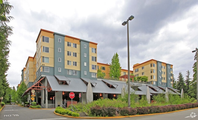
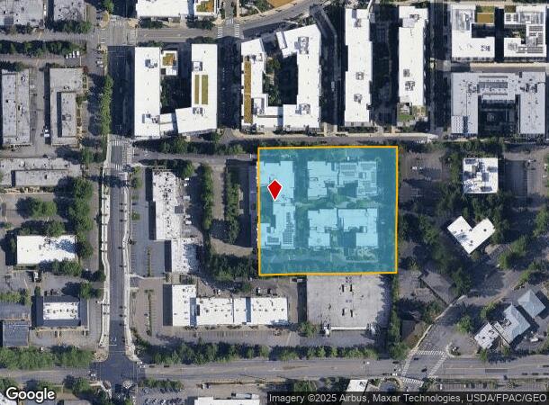
15357 Bel Red Rd
Seattle-Tacoma-Bellevue, WA
Village At Overlake Station-Bsp
894442-0020
VILLAGE AT OVERLAKE STATION-BSP
Multifamilyacreage
King
X
Washington
53033C0369G
2
2021
3.42 AC
2024
Overlake
032331
Seattle/Puget Sound
DEMOGRAPHICS near 15357 Bel Red Rd
1 Mile
3 Mile
5 Mile
2024 Total Population
22,774
115,154
272,203
2029 Population
23,252
116,860
275,784
Pop Growth 2024-2029
+ 2.10%
+ 1.48%
+ 1.32%
Average Age
36
37
38
2024 Total Households
10,240
47,660
110,199
HH Growth 2024-2029
+ 2.31%
+ 1.60%
+ 1.41%
Median Household Inc
$112,945
$145,821
$158,067
Avg Household Size
2.20
2.30
2.40
2024 Avg HH Vehicles
1.00
2.00
2.00
Median Home Value
$878,384
$1,009,257
$1,045,402
Median Year Built
1988
1983
1986
Nearby Places
Map Layers
Map Styles
 Street
 Aerial
- Restaurants
- Banks
- Shops
- Fitness
- Groceries
PUBLIC TRANSPORTATION
TRANSIT/SUBWAY
Overlake Village (South Bellevue - Redmond Tech - Sound Transit)
DRIVE
WALK
Distance
Overlake Village (South Bellevue - Redmond Tech - Sound Transit)
2 min
8 min
0.5 mi
AIRPORT
Seattle-Tacoma International
DRIVE
WALK
Distance
Seattle-Tacoma International
33 min
21.6 mi
Seattle Paine Field International
DRIVE
WALK
Distance
Seattle Paine Field International
37 min
24.9 mi
Freight Ports
Port of Seattle
DRIVE
WALK
Distance
Port of Seattle
27 min
17.2 mi
Nearby Properties
Address
Land Use
TOTAL SIZE
Lot Size
Zoning
Address
Land Use
TOTAL SIZE
Lot Size
Zoning
223,745 SF
98.45 AC
OBAT
Address
Land Use
TOTAL SIZE
Lot Size
Zoning
482,658 SF
5.78 AC
BR-CR
Address
Land Use
TOTAL SIZE
Lot Size
Zoning
300,118 SF
29.12 AC
OBAT
Address
Land Use
TOTAL SIZE
Lot Size
Zoning
574,970 SF
1.72 AC
DNTNO-1
Address
Land Use
TOTAL SIZE
Lot Size
Zoning
215,279 SF
14.92 AC
OBAT
Address
Land Use
TOTAL SIZE
Lot Size
Zoning
134,200 SF
4.04 AC
DT-OLB-N
Address
Land Use
TOTAL SIZE
Lot Size
Zoning
146,798 SF
19.63 AC
OBAT
Address
Land Use
TOTAL SIZE
Lot Size
Zoning
171,186 SF
16.45 AC
OBAT
Address
Land Use
TOTAL SIZE
Lot Size
Zoning
353,024 SF
3.19 AC
OV
Address
Land Use
TOTAL SIZE
Lot Size
Zoning
424,532 SF
30.49 AC
OUMF
Address
Land Use
TOTAL SIZE
Lot Size
Zoning
695,328 SF
4.81 AC
DT-O-2-E
Address
Land Use
TOTAL SIZE
Lot Size
Zoning
10,500 SF
2.33 AC
BR-RC-2
Address
Land Use
TOTAL SIZE
Lot Size
Zoning
210,846 SF
9.09 AC
OBAT
Address
Land Use
TOTAL SIZE
Lot Size
Zoning
113,412 SF
10.26 AC
OBAT
Address
Land Use
TOTAL SIZE
Lot Size
Zoning
120,444 SF
25.29 AC
OBAT
Address
Land Use
TOTAL SIZE
Lot Size
Zoning
188,062 SF
0.91 AC
DNTN-MU
Address
Land Use
TOTAL SIZE
Lot Size
Zoning
2.25 AC
DNTNO-1
Address
Land Use
TOTAL SIZE
Lot Size
Zoning
274,912 SF
3.25 AC
BR-RC-3
Address
Land Use
TOTAL SIZE
Lot Size
Zoning
230,239 SF
1.77 AC
DNTN-MU
Address
Land Use
TOTAL SIZE
Lot Size
Zoning
300,236 SF
1.94 AC
DT-MU-CC
Address
Land Use
TOTAL SIZE
Lot Size
Zoning
355,212 SF
19.10 AC
R-30
Address
Land Use
TOTAL SIZE
Lot Size
Zoning
457,543 SF
1.83 AC
OV
Address
Land Use
TOTAL SIZE
Lot Size
Zoning
342,000 SF
24.18 AC
OUMF
Address
Land Use
TOTAL SIZE
Lot Size
Zoning
324,656 SF
15.40 AC
R-30
Address
Land Use
TOTAL SIZE
Lot Size
Zoning
102,562 SF
4.77 AC
DT-OLB-S
Address
Land Use
TOTAL SIZE
Lot Size
Zoning
231,088 SF
2.10 AC
TWNC
Address
Land Use
TOTAL SIZE
Lot Size
Zoning
181,480 SF
0.88 AC
DNTN-R
Address
Land Use
TOTAL SIZE
Lot Size
Zoning
135,130 SF
18.59 AC
BR-OR-2
Address
Land Use
TOTAL SIZE
Lot Size
Zoning
209,322 SF
1.45 AC
OV
Address
Land Use
TOTAL SIZE
Lot Size
Zoning
282,532 SF
16.57 AC
NMF
The World's #1 Commercial Real Estate Marketplace
Connect with us
© 2025 CoStar Group
The information above has been obtained from sources believed reliable. While we do not doubt its accuracy we have not verified it and make no guarantee, warranty or representation about it. It is your responsibility to independently confirm its accuracy and completeness. Any projections, opinions, assumptions, or estimates used are for example only and do not represent the current or future performance of the property. The value of this transaction to you depends on tax and other factors which should be evaluated by your tax, financial, and legal advisors. You and your advisors should conduct a careful, independent investigation of the property to determine to your satisfaction the suitability of the property for your needs.