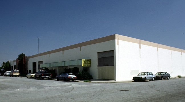
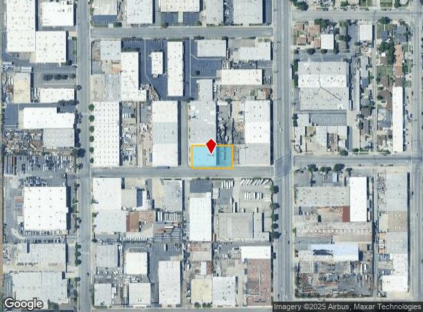
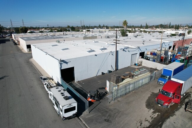
Property Record
15360 Allen St, Paramount, CA 90723
NEARBY LISTINGS FOR SALE OR LEASE
Property Detail
15360 Allen St
6240-009-082
PARCEL MAP AS PER BK 3 PG 45 OF P M LOT 4
Lightindustrial
Los Angeles
X
California
06037C1820F
4
2024
0.46 AC
2025
Downey/Paramount
553801
Los Angeles
12,000 SF
Los Angeles-Long Beach-Glendale, CA
DEMOGRAPHICS near 15360 Allen St
1 Mile
3 Mile
5 Mile
2024 Total Population
28,533
311,633
732,023
2029 Population
27,473
299,909
703,862
Pop Growth 2024-2029
(3.71%)
(3.76%)
(3.85%)
Average Age
36
36
37
2024 Total Households
7,608
84,997
205,429
HH Growth 2024-2029
(3.97%)
(3.99%)
(4.06%)
Median Household Inc
$56,647
$66,897
$71,120
Avg Household Size
3.60
3.50
3.40
2024 Avg HH Vehicles
2.00
2.00
2.00
Median Home Value
$450,000
$579,084
$631,753
Median Year Built
1967
1958
1957
Nearby Places
Map Layers
Map Styles
 Street
 Aerial
- Restaurants
- Banks
- Shops
- Fitness
- Groceries
PUBLIC TRANSPORTATION
COMMUTER RAIL
Commerce (91 Line - Southern California Regional Rail Authority (Metrolink), Orange County Line - Southern California Regional Rail Authority (Metrolink))
DRIVE
WALK
Distance
Commerce (91 Line - Southern California Regional Rail Authority (Metrolink), Orange County Line - Southern California Regional Rail Authority (Metrolink))
17 min
7.6 mi
Norwalk/Santa Fe Springs (91 Line - Southern California Regional Rail Authority (Metrolink), Orange County Line - Southern California Regional Rail Authority (Metrolink))
DRIVE
WALK
Distance
Norwalk/Santa Fe Springs (91 Line - Southern California Regional Rail Authority (Metrolink), Orange County Line - Southern California Regional Rail Authority (Metrolink))
14 min
7.9 mi
AIRPORT
Long Beach (Daugherty Field)
DRIVE
WALK
Distance
Long Beach (Daugherty Field)
12 min
5.7 mi
Los Angeles International
DRIVE
WALK
Distance
Los Angeles International
23 min
16.8 mi
John Wayne/Orange County
DRIVE
WALK
Distance
John Wayne/Orange County
36 min
27.5 mi
Freight Ports
Port of Long Beach
DRIVE
WALK
Distance
Port of Long Beach
18 min
11.2 mi
SALE & LEASE HISTORY
LISTING DATE
SALE/LEASE

Jan 17, 2024
For Lease
Nearby Properties
Address
Land Use
TOTAL SIZE
Lot Size
Zoning
Address
Land Use
TOTAL SIZE
Lot Size
Zoning
1,339,758 SF
28.53 AC
DOM2-P*
Address
Land Use
TOTAL SIZE
Lot Size
Zoning
313,224 SF
4.41 AC
SGM2*
Address
Land Use
TOTAL SIZE
Lot Size
Zoning
556,348 SF
26.38 AC
PAM2
Address
Land Use
TOTAL SIZE
Lot Size
Zoning
730,731 SF
14.89 AC
BFCG*
Address
Land Use
TOTAL SIZE
Lot Size
Zoning
373,498 SF
5.20 AC
LBR4R
Address
Land Use
TOTAL SIZE
Lot Size
Zoning
395,436 SF
17.22 AC
LBMG
Address
Land Use
TOTAL SIZE
Lot Size
Zoning
130,977 SF
5.55 AC
LCM2*
Address
Land Use
TOTAL SIZE
Lot Size
Zoning
622,175 SF
14.25 AC
LCM11/2*
Address
Land Use
TOTAL SIZE
Lot Size
Zoning
292,696 SF
11.48 AC
LBR4
Address
Land Use
TOTAL SIZE
Lot Size
Zoning
132,404 SF
4.84 AC
LBIG
Address
Land Use
TOTAL SIZE
Lot Size
Zoning
106,028 SF
6.42 AC
DOM2-P*
Address
Land Use
TOTAL SIZE
Lot Size
Zoning
233,030 SF
10.95 AC
LBR4
Address
Land Use
TOTAL SIZE
Lot Size
Zoning
108,564 SF
2.48 AC
LBR4N
Address
Land Use
TOTAL SIZE
Lot Size
Zoning
120,000 SF
LCM1
Address
Land Use
TOTAL SIZE
Lot Size
Zoning
96,849 SF
7.56 AC
LKC3YY
Address
Land Use
TOTAL SIZE
Lot Size
Zoning
183,128 SF
10.77 AC
PAM2*
Address
Land Use
TOTAL SIZE
Lot Size
Zoning
149,723 SF
9.90 AC
LBIG
Address
Land Use
TOTAL SIZE
Lot Size
Zoning
77,168 SF
2.90 AC
DOR3-P*
Address
Land Use
TOTAL SIZE
Lot Size
Zoning
126,905 SF
7.87 AC
LBCHW
Address
Land Use
TOTAL SIZE
Lot Size
Zoning
105,229 SF
2.08 AC
PACM*
Address
Land Use
TOTAL SIZE
Lot Size
Zoning
150,185 SF
2.78 AC
BFM1-CG*
Address
Land Use
TOTAL SIZE
Lot Size
Zoning
380,681 SF
8.84 AC
BFM1*
Address
Land Use
TOTAL SIZE
Lot Size
Zoning
104,912 SF
4.79 AC
LKM1-C3*
Address
Land Use
TOTAL SIZE
Lot Size
Zoning
69,530 SF
2.27 AC
LBCCA
Address
Land Use
TOTAL SIZE
Lot Size
Zoning
51,593 SF
3.92 AC
LYM*
Address
Land Use
TOTAL SIZE
Lot Size
Zoning
45,726 SF
1.56 AC
BFCG-R3-R1
Address
Land Use
TOTAL SIZE
Lot Size
Zoning
114,768 SF
18.82 AC
LBIG
Address
Land Use
TOTAL SIZE
Lot Size
Zoning
446,770 SF
10.22 AC
LBIL
The World's #1 Commercial Real Estate Marketplace
Connect with us
© 2025 CoStar Group
The information above has been obtained from sources believed reliable. While we do not doubt its accuracy we have not verified it and make no guarantee, warranty or representation about it. It is your responsibility to independently confirm its accuracy and completeness. Any projections, opinions, assumptions, or estimates used are for example only and do not represent the current or future performance of the property. The value of this transaction to you depends on tax and other factors which should be evaluated by your tax, financial, and legal advisors. You and your advisors should conduct a careful, independent investigation of the property to determine to your satisfaction the suitability of the property for your needs.