Property Record
15361 Highway 5, Cabot, AR 72023

Property Detail
15361 Highway 5
Little Rock-North Little Rock-Conway, AR
PT SE SE & S1/2 NE SE
729-10302-000
Lonoke
Commercialacreage
Arkansas
AE The base floodplain where base flood elevations are provided. AE Zones are now used on new format FIRMs instead of A1-A30 Zones.
10.72 AC
2023
Lonoke County
2025
Little Rock/N Little Rock
020106
NEARBY LISTINGS FOR SALE OR LEASE
-
-
View all Cabot listings for sale on LoopNet.com
DEMOGRAPHICS near 15361 Highway 5
1 mile
3 mile
5 mile
2025 Total Population
1,467
9,696
25,552
2030 Population
1,504
9,892
26,094
Pop Growth 2025-2030
+ 2.52%
+ 2.02%
+ 2.12%
Average Age
40
40
39
2025 Total Households
515
3,477
9,650
HH Growth 2025-2030
+ 2.72%
+ 2.04%
+ 2.18%
Median Household Inc
$108,049
$101,495
$76,924
Avg Household Size
2.80
2.80
2.60
2025 Avg HH Vehicles
2.00
2.00
2.00
Median Home Value
$252,554
$243,064
$208,193
Median Year Built
2003
1999
1996
Nearby Places
Map Layers
Map Styles
 Street
 Aerial
Layers
 Traffic
 Biking
Places
Listings with unknown addresses are not visible on the map
- Restaurants
- Banks
- Shops
- Fitness
- Groceries
PUBLIC TRANSPORTATION
AIRPORT
Bill and Hillary Clinton Ntl/Adams Field
Drive
Walk
Distance
Bill and Hillary Clinton Ntl/Adams Field
34 min
26.9 mi
Freight Ports
Port of Shreveport
Drive
Walk
Distance
Port of Shreveport
280 min
257.8 mi
SALE & LEASE HISTORY
LISTING DATE
SALE/LEASE

Sep 24, 2016
For Sale
Nearby Properties
Address
Land Use
TOTAL SIZE
Lot Size
Zoning
Address
Land Use
TOTAL SIZE
Lot Size
Zoning
150,958 SF
10.19 AC
Address
Land Use
TOTAL SIZE
Lot Size
Zoning
199,090 SF
9.82 AC
Address
Land Use
TOTAL SIZE
Lot Size
Zoning
44,675 SF
4.43 AC
Address
Land Use
TOTAL SIZE
Lot Size
Zoning
109,648 SF
9.05 AC
Address
Land Use
TOTAL SIZE
Lot Size
Zoning
25,956 SF
3.22 AC
Address
Land Use
TOTAL SIZE
Lot Size
Zoning
62,250 SF
8.59 AC
Address
Land Use
TOTAL SIZE
Lot Size
Zoning
60,322 SF
10 AC
Address
Land Use
TOTAL SIZE
Lot Size
Zoning
28,943 SF
3.39 AC
Address
Land Use
TOTAL SIZE
Lot Size
Zoning
99,270 SF
1.38 AC
Address
Land Use
TOTAL SIZE
Lot Size
Zoning
8,786 SF
3 AC
Address
Land Use
TOTAL SIZE
Lot Size
Zoning
9,588 SF
1.21 AC
Address
Land Use
TOTAL SIZE
Lot Size
Zoning
3,982 SF
13.69 AC
Address
Land Use
TOTAL SIZE
Lot Size
Zoning
18,420 SF
2.66 AC
Address
Land Use
TOTAL SIZE
Lot Size
Zoning
24,475 SF
2.85 AC
Address
Land Use
TOTAL SIZE
Lot Size
Zoning
9,604 SF
1.42 AC
Address
Land Use
TOTAL SIZE
Lot Size
Zoning
10,468 SF
1.22 AC
Address
Land Use
TOTAL SIZE
Lot Size
Zoning
7,104 SF
8.93 AC
Address
Land Use
TOTAL SIZE
Lot Size
Zoning
16,600 SF
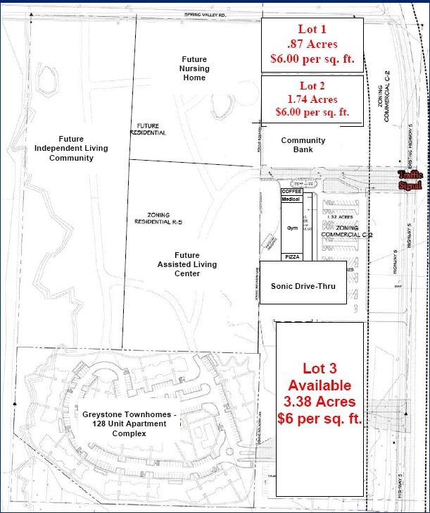
3.38 AC
Address
Land Use
TOTAL SIZE
Lot Size
Zoning
12,320 SF
1.26 AC
Address
Land Use
TOTAL SIZE
Lot Size
Zoning
5,520 SF
55.11 AC
Address
Land Use
TOTAL SIZE
Lot Size
Zoning
3,845 SF
1.31 AC
Address
Land Use
TOTAL SIZE
Lot Size
Zoning
6,686 SF
1.33 AC
Address
Land Use
TOTAL SIZE
Lot Size
Zoning
3,819 SF
3.16 AC
Address
Land Use
TOTAL SIZE
Lot Size
Zoning
11,603 SF
1.21 AC
Address
Land Use
TOTAL SIZE
Lot Size
Zoning
0.07 AC
Address
Land Use
TOTAL SIZE
Lot Size
Zoning
2,016 SF
2.02 AC
Address
Land Use
TOTAL SIZE
Lot Size
Zoning
9,716 SF
1.45 AC
Address
Land Use
TOTAL SIZE
Lot Size
Zoning
38,790 SF
2.50 AC
Address
Land Use
TOTAL SIZE
Lot Size
Zoning
8,736 SF
1.67 AC
Address
Land Use
TOTAL SIZE
Lot Size
Zoning
2,521 SF
1.13 AC
The World's #1 Commercial Real Estate Marketplace
Connect with us
© 2026 CoStar Group
The information above has been obtained from sources believed reliable. While we do not doubt its accuracy we have not verified it and make no guarantee, warranty or representation about it. It is your responsibility to independently confirm its accuracy and completeness. Any projections, opinions, assumptions, or estimates used are for example only and do not represent the current or future performance of the property. The value of this transaction to you depends on tax and other factors which should be evaluated by your tax, financial, and legal advisors. You and your advisors should conduct a careful, independent investigation of the property to determine to your satisfaction the suitability of the property for your needs.