Property Record
15380 Sw 75Th Ave, Starke, FL 32091
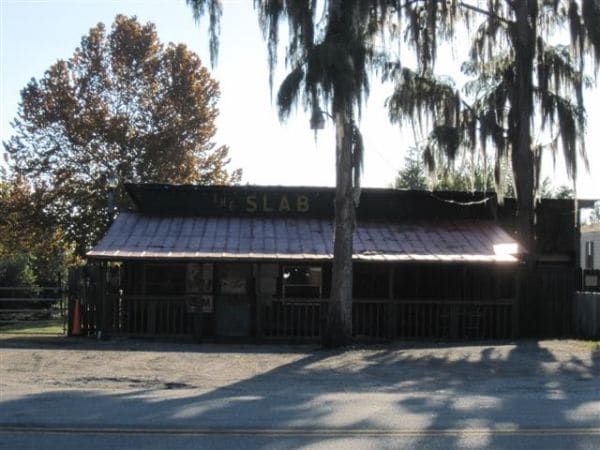


Property Detail
15380 Sw 75Th Ave
00805-0-00707
26 6S 21 COM SW COR OF SE1/4 OF NE1/4. S1*16'E 889.71', S69*28'30"E 1378.88', N59*48'50"E 864.18', S87*42'E 2772.92', S30*14'E 796' TO POB. S30*14'E 156', S59*46'W 779.64' M/L TO WATERS EDGE, NWLY 157', N59*46'E 747' TO POB.
Storemultistory
Bradford
AE The base floodplain where base flood elevations are provided. AE Zones are now used on new format FIRMs instead of A1-A30 Zones.
Florida
2025
2.58 AC
2025
Florida Central North Area
000201
Other Market Areas
4,402 SF
NEARBY LISTINGS FOR SALE OR LEASE
-
-
View all Starke listings for sale on LoopNet.com
DEMOGRAPHICS near 15380 Sw 75Th Ave
1 mile
3 mile
5 mile
2025 Total Population
217
2,842
11,510
2030 Population
231
3,018
12,244
Pop Growth 2025-2030
+ 6.45%
+ 6.19%
+ 6.38%
Average Age
43
42
41
2025 Total Households
90
1,106
4,334
HH Growth 2025-2030
+ 5.56%
+ 5.61%
+ 6.00%
Median Household Inc
$75,735
$61,536
$49,953
Avg Household Size
2.40
2.50
2.50
2025 Avg HH Vehicles
2.00
2.00
2.00
Median Home Value
$216,667
$218,807
$204,387
Median Year Built
1987
1984
1983
Nearby Places
Map Layers
Map Styles
 Street
 Aerial
Layers
 Traffic
 Biking
Places
Listings with unknown addresses are not visible on the map
- Restaurants
- Banks
- Shops
- Fitness
- Groceries
PUBLIC TRANSPORTATION
AIRPORT
Gainesville Regional
Drive
Walk
Distance
Gainesville Regional
41 min
27.4 mi
Freight Ports
Jacksonville Port
Drive
Walk
Distance
Jacksonville Port
71 min
54.0 mi
SALE & LEASE HISTORY
LISTING DATE
SALE/LEASE

Sep 23, 2016
For Sale
Jan 11, 2019
For Sale
Aug 04, 2017
For Sale
Nearby Properties
Address
Land Use
TOTAL SIZE
Lot Size
Zoning
Address
Land Use
TOTAL SIZE
Lot Size
Zoning
168,336 SF
23.97 AC
Address
Land Use
TOTAL SIZE
Lot Size
Zoning
104,030 SF
24.65 AC
Address
Land Use
TOTAL SIZE
Lot Size
Zoning
9,314 SF
1.46 AC
Address
Land Use
TOTAL SIZE
Lot Size
Zoning
22,315 SF
2 AC
Address
Land Use
TOTAL SIZE
Lot Size
Zoning
16,512 SF
5.25 AC
Address
Land Use
TOTAL SIZE
Lot Size
Zoning
45,576 SF
8.34 AC
Address
Land Use
TOTAL SIZE
Lot Size
Zoning
15,440 SF
2.97 AC
Address
Land Use
TOTAL SIZE
Lot Size
Zoning
1,624 SF
0.79 AC
Address
Land Use
TOTAL SIZE
Lot Size
Zoning
22,774 SF
2.50 AC
Address
Land Use
TOTAL SIZE
Lot Size
Zoning
25,715 SF
3.57 AC
Address
Land Use
TOTAL SIZE
Lot Size
Zoning
15,796 SF
1.15 AC
Address
Land Use
TOTAL SIZE
Lot Size
Zoning
4,245 SF
0.57 AC
Address
Land Use
TOTAL SIZE
Lot Size
Zoning
9,770 SF
1.34 AC
Address
Land Use
TOTAL SIZE
Lot Size
Zoning
2,571 SF
0.72 AC
Address
Land Use
TOTAL SIZE
Lot Size
Zoning
8,119 SF
0.57 AC
Address
Land Use
TOTAL SIZE
Lot Size
Zoning
4,939 SF
5.87 AC
Address
Land Use
TOTAL SIZE
Lot Size
Zoning
43.62 AC
Address
Land Use
TOTAL SIZE
Lot Size
Zoning
11.43 AC
Address
Land Use
TOTAL SIZE
Lot Size
Zoning
3,554 SF
33 AC
Address
Land Use
TOTAL SIZE
Lot Size
Zoning
5,908 SF
3.07 AC
Address
Land Use
TOTAL SIZE
Lot Size
Zoning
5,082 SF
10.57 AC
Address
Land Use
TOTAL SIZE
Lot Size
Zoning
4,102 SF
5.72 AC
Address
Land Use
TOTAL SIZE
Lot Size
Zoning
250 AC
Address
Land Use
TOTAL SIZE
Lot Size
Zoning
21,880 SF
2.54 AC
Address
Land Use
TOTAL SIZE
Lot Size
Zoning
3,752 SF
28.56 AC
Address
Land Use
TOTAL SIZE
Lot Size
Zoning
5,765 SF
1.63 AC
Address
Land Use
TOTAL SIZE
Lot Size
Zoning
9,000 SF
4.82 AC
Address
Land Use
TOTAL SIZE
Lot Size
Zoning
1,488 SF
20.40 AC
Address
Land Use
TOTAL SIZE
Lot Size
Zoning
5,539 SF
16.99 AC
Address
Land Use
TOTAL SIZE
Lot Size
Zoning
40,822 SF
12.19 AC
The World's #1 Commercial Real Estate Marketplace
Connect with us
© 2026 CoStar Group
The information above has been obtained from sources believed reliable. While we do not doubt its accuracy we have not verified it and make no guarantee, warranty or representation about it. It is your responsibility to independently confirm its accuracy and completeness. Any projections, opinions, assumptions, or estimates used are for example only and do not represent the current or future performance of the property. The value of this transaction to you depends on tax and other factors which should be evaluated by your tax, financial, and legal advisors. You and your advisors should conduct a careful, independent investigation of the property to determine to your satisfaction the suitability of the property for your needs.