Property Record
15385 W Fillmore St, Goodyear, AZ 85338


NEARBY LISTINGS FOR SALE OR LEASE
-
-
View all Goodyear listings for sale on LoopNet.com
Property Detail
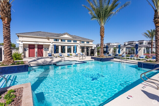
15385 W Fillmore St
Phoenix-Mesa-Scottsdale, AZ
Christopher Todd Communities At Estrella
500-10-861
CHRISTOPHER TODD COMMUNITIES AT ESTRELLA COMMONS MCR 1417-44
Apartment
Maricopa
X
Arizona
04013C2135L
1
2025
22.29 AC
2025
Canyon Trails
061053
Phoenix
246,621 SF
DEMOGRAPHICS near 15385 W Fillmore St
1 Mile
3 Mile
5 Mile
2024 Total Population
10,464
85,094
164,272
2029 Population
11,975
93,839
180,136
Pop Growth 2024-2029
+ 14.44%
+ 10.28%
+ 9.66%
Average Age
34
40
38
2024 Total Households
3,395
29,633
54,394
HH Growth 2024-2029
+ 14.32%
+ 10.51%
+ 9.82%
Median Household Inc
$74,310
$82,275
$85,574
Avg Household Size
3.00
2.80
2.90
2024 Avg HH Vehicles
2.00
2.00
2.00
Median Home Value
$337,075
$383,799
$371,716
Median Year Built
2010
2005
2005
Nearby Places
Map Layers
Map Styles
 Street
 Aerial
- Restaurants
- Banks
- Shops
- Fitness
- Groceries
PUBLIC TRANSPORTATION
AIRPORT
Phoenix Sky Harbor International
DRIVE
WALK
Distance
Phoenix Sky Harbor International
34 min
25.5 mi
Freight Ports
Port of San Diego
DRIVE
WALK
Distance
Port of San Diego
374 min
337.1 mi
Nearby Properties
Address
Land Use
TOTAL SIZE
Lot Size
Zoning
Address
Land Use
TOTAL SIZE
Lot Size
Zoning
16.70 AC
Address
Land Use
TOTAL SIZE
Lot Size
Zoning
76,301 SF
15.91 AC
Address
Land Use
TOTAL SIZE
Lot Size
Zoning
551,831 SF
609.49 AC
AG
Address
Land Use
TOTAL SIZE
Lot Size
Zoning
49,475 SF
5.70 AC
PAD
Address
Land Use
TOTAL SIZE
Lot Size
Zoning
370,726 SF
23.41 AC
PAD
Address
Land Use
TOTAL SIZE
Lot Size
Zoning
324,374 SF
18.26 AC
PAD
Address
Land Use
TOTAL SIZE
Lot Size
Zoning
2.51 AC
Address
Land Use
TOTAL SIZE
Lot Size
Zoning
1,310,258 SF
79.03 AC
PAD
Address
Land Use
TOTAL SIZE
Lot Size
Zoning
563,328 SF
24.43 AC
C2
Address
Land Use
TOTAL SIZE
Lot Size
Zoning
438,256 SF
48.59 AC
Address
Land Use
TOTAL SIZE
Lot Size
Zoning
1,126,656 SF
35.76 AC
I1
Address
Land Use
TOTAL SIZE
Lot Size
Zoning
901,699 SF
49.92 AC
I1
Address
Land Use
TOTAL SIZE
Lot Size
Zoning
220,494 SF
50.53 AC
AG
Address
Land Use
TOTAL SIZE
Lot Size
Zoning
855,336 SF
45.11 AC
Address
Land Use
TOTAL SIZE
Lot Size
Zoning
802,671 SF
48.81 AC
I1
Address
Land Use
TOTAL SIZE
Lot Size
Zoning
320,888 SF
31.41 AC
C-G
Address
Land Use
TOTAL SIZE
Lot Size
Zoning
398,872 SF
9.39 AC
PAD
Address
Land Use
TOTAL SIZE
Lot Size
Zoning
601,124 SF
39.88 AC
PAD
Address
Land Use
TOTAL SIZE
Lot Size
Zoning
790,980 SF
42.95 AC
I1
Address
Land Use
TOTAL SIZE
Lot Size
Zoning
643,756 SF
39.25 AC
PAD
Address
Land Use
TOTAL SIZE
Lot Size
Zoning
222,900 SF
15.99 AC
Address
Land Use
TOTAL SIZE
Lot Size
Zoning
643,798 SF
39.40 AC
PAD
Address
Land Use
TOTAL SIZE
Lot Size
Zoning
355,597 SF
14.83 AC
PAD
Address
Land Use
TOTAL SIZE
Lot Size
Zoning
337,781 SF
9.11 AC
PF
Address
Land Use
TOTAL SIZE
Lot Size
Zoning
295,635 SF
16.57 AC
PAD
Address
Land Use
TOTAL SIZE
Lot Size
Zoning
293,849 SF
33.20 AC
PAD
Address
Land Use
TOTAL SIZE
Lot Size
Zoning
392,000 SF
26.57 AC
PAD
Address
Land Use
TOTAL SIZE
Lot Size
Zoning
663,150 SF
34.49 AC
Address
Land Use
TOTAL SIZE
Lot Size
Zoning
450,619 SF
28.95 AC
I2
Address
Land Use
TOTAL SIZE
Lot Size
Zoning
54,562 SF
7.65 AC
PAD
The World's #1 Commercial Real Estate Marketplace
Connect with us
© 2025 CoStar Group
The information above has been obtained from sources believed reliable. While we do not doubt its accuracy we have not verified it and make no guarantee, warranty or representation about it. It is your responsibility to independently confirm its accuracy and completeness. Any projections, opinions, assumptions, or estimates used are for example only and do not represent the current or future performance of the property. The value of this transaction to you depends on tax and other factors which should be evaluated by your tax, financial, and legal advisors. You and your advisors should conduct a careful, independent investigation of the property to determine to your satisfaction the suitability of the property for your needs.