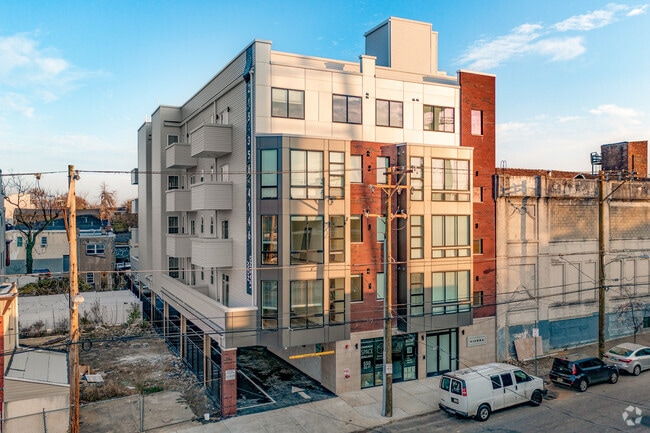
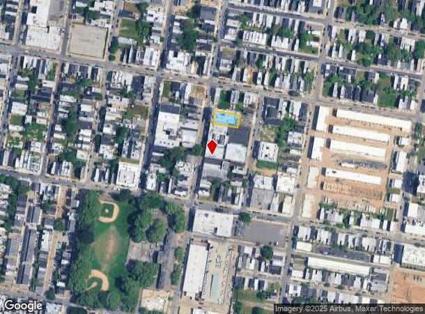
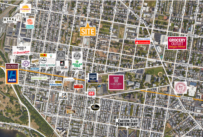
Property Record
1539 N 26Th St, Philadelphia, PA 19121
Current Lease Availabilities
NEARBY LISTINGS FOR SALE OR LEASE
Property Detail
1539 N 26Th St
881809870
846 N OF JEFFERSON
Apartment
Philadelphia
X
Pennsylvania
42045C0150F
0.18 AC
2024
Brewerytown
2026
Philadelphia
013800
Philadelphia-Camden-Wilmington, PA-NJ-DE-MD
24,015 SF
DEMOGRAPHICS near 1539 N 26Th St
1 Mile
3 Mile
5 Mile
2024 Total Population
67,097
495,449
1,094,170
2029 Population
66,870
488,286
1,069,970
Pop Growth 2024-2029
(0.34%)
(1.45%)
(2.21%)
Average Age
35
36
37
2024 Total Households
29,370
222,854
456,114
HH Growth 2024-2029
(0.57%)
(1.82%)
(2.46%)
Median Household Inc
$46,781
$55,437
$52,206
Avg Household Size
2.10
2.00
2.20
2024 Avg HH Vehicles
1.00
1.00
1.00
Median Home Value
$284,675
$304,160
$233,703
Median Year Built
1951
1952
1948
Nearby Places
- Restaurants
- Banks
- Shops
- Fitness
- Groceries
PUBLIC TRANSPORTATION
TRANSIT/SUBWAY
Girard Av & 26Th St (63rd-Girard to Richmond-Westmorelnd - SEPTA)
DRIVE
WALK
Distance
Girard Av & 26Th St (63rd-Girard to Richmond-Westmorelnd - SEPTA)
1 min
6 min
0.4 mi
Girard Av & 27Th St (63rd-Girard to Richmond-Westmorelnd - SEPTA)
DRIVE
WALK
Distance
Girard Av & 27Th St (63rd-Girard to Richmond-Westmorelnd - SEPTA)
2 min
8 min
0.4 mi
26Th St & Poplar St (63rd-Girard to Richmond-Westmorelnd - SEPTA)
DRIVE
WALK
Distance
26Th St & Poplar St (63rd-Girard to Richmond-Westmorelnd - SEPTA)
1 min
8 min
0.4 mi
Girard Av & 28Th St (63rd-Girard to Richmond-Westmorelnd - SEPTA)
DRIVE
WALK
Distance
Girard Av & 28Th St (63rd-Girard to Richmond-Westmorelnd - SEPTA)
2 min
9 min
0.5 mi
Girard Av & 29Th St (63rd-Girard to Richmond-Westmorelnd - SEPTA)
DRIVE
WALK
Distance
Girard Av & 29Th St (63rd-Girard to Richmond-Westmorelnd - SEPTA)
2 min
11 min
0.6 mi
COMMUTER RAIL
30Th St Lower Level (Airport Line - SEPTA, Wilmington/Newark Line - SEPTA)
DRIVE
WALK
Distance
30Th St Lower Level (Airport Line - SEPTA, Wilmington/Newark Line - SEPTA)
5 min
1.9 mi
Temple University (R1 - Southeastern Pennsylvania Transportation Authority Regional Rail (SEPTA Regional Rail), R2 - Southeastern Pennsylvania Transportation Authority Regional Rail (SEPTA Regional Rail), R3 - Southeastern Pennsylvania Transportation Authority Regional Rail (SEPTA Regional Rail), R5 - Southeastern Pennsylvania Transportation Authority Regional Rail (SEPTA Regional Rail), R6 - Southeastern Pennsylvania Transportation Authority Regional Rail (SEPTA Regional Rail), R7 - Southeastern Pennsylvania Transportation Authority Regional Rail (SEPTA Regional Rail), R8 - Southeastern Pennsylvania Transportation Authority Regional Rail (SEPTA Regional Rail))
DRIVE
WALK
Distance
Temple University (R1 - Southeastern Pennsylvania Transportation Authority Regional Rail (SEPTA Regional Rail), R2 - Southeastern Pennsylvania Transportation Authority Regional Rail (SEPTA Regional Rail), R3 - Southeastern Pennsylvania Transportation Authority Regional Rail (SEPTA Regional Rail), R5 - Southeastern Pennsylvania Transportation Authority Regional Rail (SEPTA Regional Rail), R6 - Southeastern Pennsylvania Transportation Authority Regional Rail (SEPTA Regional Rail), R7 - Southeastern Pennsylvania Transportation Authority Regional Rail (SEPTA Regional Rail), R8 - Southeastern Pennsylvania Transportation Authority Regional Rail (SEPTA Regional Rail))
7 min
2.2 mi
AIRPORT
Philadelphia International
DRIVE
WALK
Distance
Philadelphia International
24 min
11.8 mi
Trenton Mercer
DRIVE
WALK
Distance
Trenton Mercer
53 min
35.5 mi
Freight Ports
South Jersey Port
DRIVE
WALK
Distance
South Jersey Port
13 min
5.7 mi
Nearby Properties
Address
Land Use
TOTAL SIZE
Lot Size
Zoning
Address
Land Use
TOTAL SIZE
Lot Size
Zoning
1,449,928 SF
1.22 AC
CMX5
Address
Land Use
TOTAL SIZE
Lot Size
Zoning
1,076,400 SF
5 AC
CMX4
Address
Land Use
TOTAL SIZE
Lot Size
Zoning
1,200,021 SF
0.69 AC
CMX5
Address
Land Use
TOTAL SIZE
Lot Size
Zoning
26,690 SF
500 AC
SPINS
Address
Land Use
TOTAL SIZE
Lot Size
Zoning
1,103,300 SF
1.18 AC
CMX5
Address
Land Use
TOTAL SIZE
Lot Size
Zoning
1,464,000 SF
0.76 AC
CMX5
Address
Land Use
TOTAL SIZE
Lot Size
Zoning
319,590 SF
0.87 AC
I2
Address
Land Use
TOTAL SIZE
Lot Size
Zoning
760,635 SF
0.77 AC
CMX5
Address
Land Use
TOTAL SIZE
Lot Size
Zoning
1,179,072 SF
8.90 AC
RM4
Address
Land Use
TOTAL SIZE
Lot Size
Zoning
1,296,804 SF
2.71 AC
I2
Address
Land Use
TOTAL SIZE
Lot Size
Zoning
782,208 SF
0.68 AC
CMX5
Address
Land Use
TOTAL SIZE
Lot Size
Zoning
2,215,276 SF
2.46 AC
CMX5
Address
Land Use
TOTAL SIZE
Lot Size
Zoning
880,950 SF
27.71 AC
SPENT
Address
Land Use
TOTAL SIZE
Lot Size
Zoning
624,696 SF
5.79 AC
CMX4
Address
Land Use
TOTAL SIZE
Lot Size
Zoning
1,200,000 SF
1.78 AC
CMX5
Address
Land Use
TOTAL SIZE
Lot Size
Zoning
1,075,580 SF
2.65 AC
CMX5
Address
Land Use
TOTAL SIZE
Lot Size
Zoning
468,307 SF
2.45 AC
CMX4
Address
Land Use
TOTAL SIZE
Lot Size
Zoning
500,165 SF
2.16 AC
SPPOA
Address
Land Use
TOTAL SIZE
Lot Size
Zoning
1,152,520 SF
1.49 AC
CMX5
Address
Land Use
TOTAL SIZE
Lot Size
Zoning
696,920 SF
10.55 AC
SPINS
Address
Land Use
TOTAL SIZE
Lot Size
Zoning
1,143,040 SF
0.81 AC
CMX5
Address
Land Use
TOTAL SIZE
Lot Size
Zoning
738,750 SF
1.19 AC
CMX5
Address
Land Use
TOTAL SIZE
Lot Size
Zoning
700,000 SF
7.88 AC
CMX5
Address
Land Use
TOTAL SIZE
Lot Size
Zoning
1,102,992 SF
2.14 AC
CMX5
Address
Land Use
TOTAL SIZE
Lot Size
Zoning
1.88 AC
SPINS
Address
Land Use
TOTAL SIZE
Lot Size
Zoning
738,207 SF
0.89 AC
CMX5
Address
Land Use
TOTAL SIZE
Lot Size
Zoning
665,742 SF
0.98 AC
CMX4
Address
Land Use
TOTAL SIZE
Lot Size
Zoning
1,152,480 SF
1.48 AC
CMX5
Address
Land Use
TOTAL SIZE
Lot Size
Zoning
1,011,079 SF
5.82 AC
CMX5
Address
Land Use
TOTAL SIZE
Lot Size
Zoning
677,140 SF
0.53 AC
CMX5
The World's #1 Commercial Real Estate Marketplace
Connect with us
© 2025 CoStar Group
The information above has been obtained from sources believed reliable. While we do not doubt its accuracy we have not verified it and make no guarantee, warranty or representation about it. It is your responsibility to independently confirm its accuracy and completeness. Any projections, opinions, assumptions, or estimates used are for example only and do not represent the current or future performance of the property. The value of this transaction to you depends on tax and other factors which should be evaluated by your tax, financial, and legal advisors. You and your advisors should conduct a careful, independent investigation of the property to determine to your satisfaction the suitability of the property for your needs.