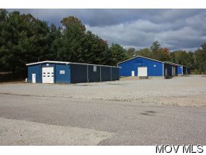
Property Record
154 Bender Rd, Marietta, OH 45750
NEARBY LISTINGS FOR SALE OR LEASE
Property Detail
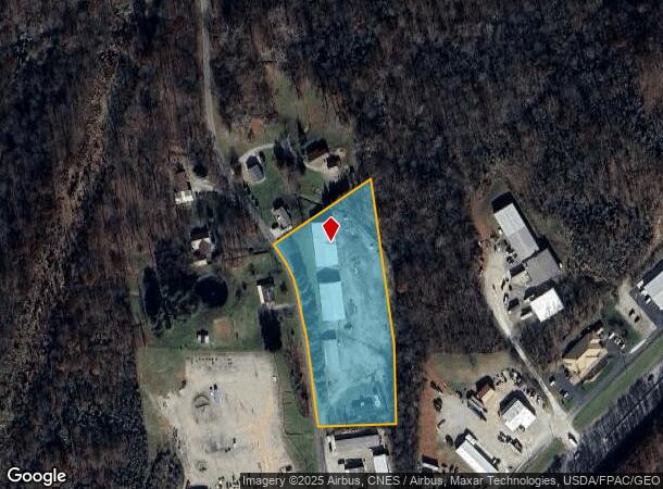
154 Bender Rd
3400-67320-000
R9 T2 S3 160 AC LOT 291 3 .54 AC
Warehouse
Washington
X
Ohio
39167C0263F
291
2024
3.54 AC
2024
Ohio South Area
020300
Other Market Areas
6,000 SF
Marietta, OH
DEMOGRAPHICS near 154 Bender Rd
1 mile
3 mile
5 mile
2024 Total Population
370
9,987
32,428
2029 Population
386
9,959
32,058
Pop Growth 2024-2029
+ 4.32%
(0.28%)
(1.14%)
Average Age
45
44
42
2024 Total Households
157
4,261
13,768
HH Growth 2024-2029
+ 4.46%
(0.31%)
(1.14%)
Median Household Inc
$59,166
$59,169
$58,542
Avg Household Size
2.30
2.20
2.20
2024 Avg HH Vehicles
2.00
2.00
2.00
Median Home Value
$142,045
$162,328
$167,415
Median Year Built
1986
1972
1969
Nearby Places
Map Layers
Map Styles
 Street
 Aerial
Transit
 Traffic
 Biking
Places
Listings with unknown addresses are not visible on the map
- Restaurants
- Banks
- Shops
- Fitness
- Groceries
Nearby Properties
Address
Land Use
TOTAL SIZE
Lot Size
Zoning
Address
Land Use
TOTAL SIZE
Lot Size
Zoning
4.50 AC
Address
Land Use
TOTAL SIZE
Lot Size
Zoning
Address
Land Use
TOTAL SIZE
Lot Size
Zoning
14.36 AC
Address
Land Use
TOTAL SIZE
Lot Size
Zoning
31.05 AC
Address
Land Use
TOTAL SIZE
Lot Size
Zoning
3.34 AC
Address
Land Use
TOTAL SIZE
Lot Size
Zoning
279.08 AC
Address
Land Use
TOTAL SIZE
Lot Size
Zoning
9,975 SF
14.36 AC
Address
Land Use
TOTAL SIZE
Lot Size
Zoning
9,975 SF
1 AC
Address
Land Use
TOTAL SIZE
Lot Size
Zoning
Address
Land Use
TOTAL SIZE
Lot Size
Zoning
Address
Land Use
TOTAL SIZE
Lot Size
Zoning
1,449 SF
1.19 AC
Address
Land Use
TOTAL SIZE
Lot Size
Zoning
0.27 AC
Address
Land Use
TOTAL SIZE
Lot Size
Zoning
29,070 SF
0.21 AC
Address
Land Use
TOTAL SIZE
Lot Size
Zoning
1.65 AC
Address
Land Use
TOTAL SIZE
Lot Size
Zoning
14.18 AC
Address
Land Use
TOTAL SIZE
Lot Size
Zoning
13,797 SF
Address
Land Use
TOTAL SIZE
Lot Size
Zoning
13,797 SF
0.61 AC
Address
Land Use
TOTAL SIZE
Lot Size
Zoning
7,107 SF
122.13 AC
Address
Land Use
TOTAL SIZE
Lot Size
Zoning
39,440 SF
5.46 AC
Address
Land Use
TOTAL SIZE
Lot Size
Zoning
3,102 SF
11.94 AC
Address
Land Use
TOTAL SIZE
Lot Size
Zoning
4,400 SF
0.17 AC
Address
Land Use
TOTAL SIZE
Lot Size
Zoning
7,281 SF
0.46 AC
Address
Land Use
TOTAL SIZE
Lot Size
Zoning
16.61 AC
Address
Land Use
TOTAL SIZE
Lot Size
Zoning
9,953 SF
0.35 AC
Address
Land Use
TOTAL SIZE
Lot Size
Zoning
2,800 SF
9.18 AC
Address
Land Use
TOTAL SIZE
Lot Size
Zoning
Address
Land Use
TOTAL SIZE
Lot Size
Zoning
0.77 AC
Address
Land Use
TOTAL SIZE
Lot Size
Zoning
7,712 SF
0.46 AC
Address
Land Use
TOTAL SIZE
Lot Size
Zoning
5,786 SF
0.90 AC
Address
Land Use
TOTAL SIZE
Lot Size
Zoning
6,212 SF
26.77 AC
The World's #1 Commercial Real Estate Marketplace
Connect with us
© 2026 CoStar Group
The information above has been obtained from sources believed reliable. While we do not doubt its accuracy we have not verified it and make no guarantee, warranty or representation about it. It is your responsibility to independently confirm its accuracy and completeness. Any projections, opinions, assumptions, or estimates used are for example only and do not represent the current or future performance of the property. The value of this transaction to you depends on tax and other factors which should be evaluated by your tax, financial, and legal advisors. You and your advisors should conduct a careful, independent investigation of the property to determine to your satisfaction the suitability of the property for your needs.