Property Record
154 Dornach Way, Advance, NC 27006
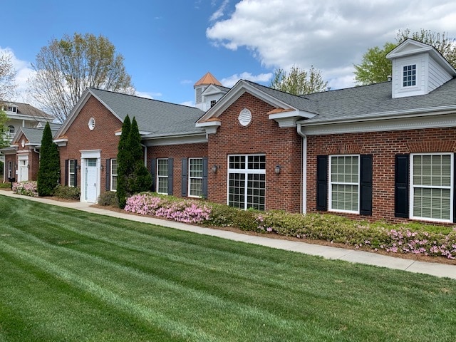


Property Detail
154 Dornach Way
C9-000-00-003-05
REMAINDER OF BLDG A
Officebuilding
DAVIE
B and X Area of moderate flood hazard, usually the area between the limits of the 100-year and 500-year floods.
North Carolina
2025
0.07 AC
2025
Davie County
080301
Greensboro/Winston-Salem
1,904 SF
Winston-Salem, NC
NEARBY LISTINGS FOR SALE OR LEASE
-
-
View all Advance listings for sale on LoopNet.com
DEMOGRAPHICS near 154 Dornach Way
1 mile
3 mile
5 mile
2025 Total Population
3,210
21,031
46,190
2030 Population
3,374
21,758
47,895
Pop Growth 2025-2030
+ 5.11%
+ 3.46%
+ 3.69%
Average Age
49
46
44
2025 Total Households
1,489
8,593
18,674
HH Growth 2025-2030
+ 5.10%
+ 3.60%
+ 3.80%
Median Household Inc
$65,482
$93,485
$86,595
Avg Household Size
2.10
2.40
2.40
2025 Avg HH Vehicles
2.00
2.00
2.00
Median Home Value
$345,258
$380,664
$348,553
Median Year Built
1983
1991
1992
Nearby Places
Map Layers
Map Styles
 Street
 Aerial
Layers
 Traffic
 Biking
Places
Listings with unknown addresses are not visible on the map
- Restaurants
- Banks
- Shops
- Fitness
- Groceries
PUBLIC TRANSPORTATION
AIRPORT
Piedmont Triad International
Drive
Walk
Distance
Piedmont Triad International
47 min
32.7 mi
SALE & LEASE HISTORY
LISTING DATE
SALE/LEASE

Sep 19, 2023
For Lease
Sep 19, 2023
For Sale
Dec 09, 2025
For Sale
Nearby Properties
Address
Land Use
TOTAL SIZE
Lot Size
Zoning
Address
Land Use
TOTAL SIZE
Lot Size
Zoning
132,856 SF
53.61 AC
R20
Address
Land Use
TOTAL SIZE
Lot Size
Zoning
130,696 SF
41.18 AC
PB-S
Address
Land Use
TOTAL SIZE
Lot Size
Zoning
100,233 SF
19.65 AC
PB-S
Address
Land Use
TOTAL SIZE
Lot Size
Zoning
81,594 SF
1,147.49 AC
IP
Address
Land Use
TOTAL SIZE
Lot Size
Zoning
23,926 SF
11.36 AC
Address
Land Use
TOTAL SIZE
Lot Size
Zoning
49,319 SF
24.81 AC
Address
Land Use
TOTAL SIZE
Lot Size
Zoning
1,971 SF
6.24 AC
HB
Address
Land Use
TOTAL SIZE
Lot Size
Zoning
655,160 SF
52.15 AC
GI
Address
Land Use
TOTAL SIZE
Lot Size
Zoning
80,171 SF
4.32 AC
PB-S
Address
Land Use
TOTAL SIZE
Lot Size
Zoning
60,296 SF
0.66 AC
PB-S
Address
Land Use
TOTAL SIZE
Lot Size
Zoning
68,277 SF
9.82 AC
GB-S
Address
Land Use
TOTAL SIZE
Lot Size
Zoning
79,498 SF
10.64 AC
HB
Address
Land Use
TOTAL SIZE
Lot Size
Zoning
71,306 SF
10.36 AC
IP-S
Address
Land Use
TOTAL SIZE
Lot Size
Zoning
129,268 SF
9.98 AC
HB-S
Address
Land Use
TOTAL SIZE
Lot Size
Zoning
101,346 SF
8.25 AC
HB-S
Address
Land Use
TOTAL SIZE
Lot Size
Zoning
46,073 SF
11.74 AC
R12
Address
Land Use
TOTAL SIZE
Lot Size
Zoning
53,969 SF
10.52 AC
RM12-S
Address
Land Use
TOTAL SIZE
Lot Size
Zoning
119,240 SF
22.72 AC
Address
Land Use
TOTAL SIZE
Lot Size
Zoning
32,696 SF
1.64 AC
PB-S
Address
Land Use
TOTAL SIZE
Lot Size
Zoning
32,656 SF
3.14 AC
IP-S
Address
Land Use
TOTAL SIZE
Lot Size
Zoning
68,028 SF
17.56 AC
IP
Address
Land Use
TOTAL SIZE
Lot Size
Zoning
79,355 SF
14.91 AC
IP-S
Address
Land Use
TOTAL SIZE
Lot Size
Zoning
60,709 SF
34.21 AC
C-S
Address
Land Use
TOTAL SIZE
Lot Size
Zoning
59,143 SF
8.49 AC
CS
Address
Land Use
TOTAL SIZE
Lot Size
Zoning
53,105 SF
5.42 AC
IP-S
Address
Land Use
TOTAL SIZE
Lot Size
Zoning
37,658 SF
3.93 AC
RM12-S
Address
Land Use
TOTAL SIZE
Lot Size
Zoning
38,727 SF
6.84 AC
RM8-S
Address
Land Use
TOTAL SIZE
Lot Size
Zoning
62,524 SF
6.79 AC
PB-S
Address
Land Use
TOTAL SIZE
Lot Size
Zoning
59,517 SF
5.90 AC
CSS
Address
Land Use
TOTAL SIZE
Lot Size
Zoning
301.66 AC
RM5-S,RS15
The World's #1 Commercial Real Estate Marketplace
Connect with us
© 2026 CoStar Group
The information above has been obtained from sources believed reliable. While we do not doubt its accuracy we have not verified it and make no guarantee, warranty or representation about it. It is your responsibility to independently confirm its accuracy and completeness. Any projections, opinions, assumptions, or estimates used are for example only and do not represent the current or future performance of the property. The value of this transaction to you depends on tax and other factors which should be evaluated by your tax, financial, and legal advisors. You and your advisors should conduct a careful, independent investigation of the property to determine to your satisfaction the suitability of the property for your needs.