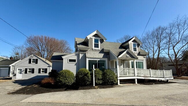
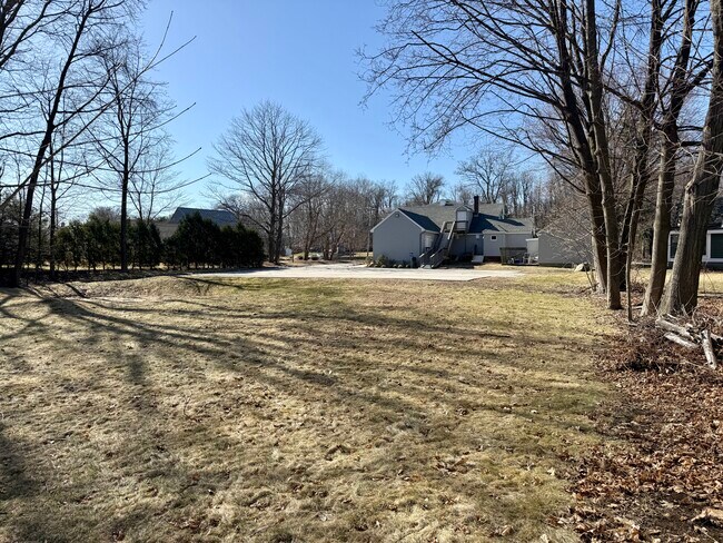
Property Record
154 W Main St, Northborough, MA 01532
NEARBY LISTINGS FOR SALE OR LEASE
Property Detail
154 W Main St
NBOR-000620-000000-000050
Worcester
Commercialofficeresidentialmixeduse
Massachusetts
X
50
25027C0634F
1.75 AC
2025
The Boroughs
2025
Boston
740200
Worcester, MA-CT
3,295 SF
DEMOGRAPHICS near 154 W Main St
1 Mile
3 Mile
5 Mile
2024 Total Population
5,172
24,018
84,267
2029 Population
5,142
24,075
83,995
Pop Growth 2024-2029
(0.58%)
+ 0.24%
(0.32%)
Average Age
42
41
41
2024 Total Households
1,949
9,058
31,694
HH Growth 2024-2029
(0.56%)
+ 0.33%
(0.31%)
Median Household Inc
$148,569
$128,692
$116,825
Avg Household Size
2.60
2.60
2.60
2024 Avg HH Vehicles
2.00
2.00
2.00
Median Home Value
$548,065
$522,862
$535,490
Median Year Built
1976
1981
1978
Nearby Places
Map Layers
Map Styles
 Street
 Aerial
- Restaurants
- Banks
- Shops
- Fitness
- Groceries
PUBLIC TRANSPORTATION
COMMUTER RAIL
Westborough (Framingham/Worcester Line - Massachusetts Bay Transportation Authority Commuter Rail (Purple Line))
DRIVE
WALK
Distance
Westborough (Framingham/Worcester Line - Massachusetts Bay Transportation Authority Commuter Rail (Purple Line))
10 min
4.4 mi
Grafton (Framingham/Worcester Line - Massachusetts Bay Transportation Authority Commuter Rail (Purple Line))
DRIVE
WALK
Distance
Grafton (Framingham/Worcester Line - Massachusetts Bay Transportation Authority Commuter Rail (Purple Line))
11 min
6.4 mi
AIRPORT
Worcester Regional
DRIVE
WALK
Distance
Worcester Regional
28 min
16.6 mi
Freight Ports
Port of Boston
DRIVE
WALK
Distance
Port of Boston
55 min
37.2 mi
SALE & LEASE HISTORY
LISTING DATE
SALE/LEASE

Sep 24, 2016
For Sale
Jan 09, 2017
For Sale
Feb 01, 2025
For Sale
Nearby Properties
Address
Land Use
TOTAL SIZE
Lot Size
Zoning
Address
Land Use
TOTAL SIZE
Lot Size
Zoning
42.01 AC
I
Address
Land Use
TOTAL SIZE
Lot Size
Zoning
339,553 SF
42.94 AC
RC
Address
Land Use
TOTAL SIZE
Lot Size
Zoning
67.29 AC
IB
Address
Land Use
TOTAL SIZE
Lot Size
Zoning
19.69 AC
BA
Address
Land Use
TOTAL SIZE
Lot Size
Zoning
205,712 SF
3.95 AC
BA
Address
Land Use
TOTAL SIZE
Lot Size
Zoning
554,193 SF
52.56 AC
I
Address
Land Use
TOTAL SIZE
Lot Size
Zoning
300,989 SF
66.90 AC
I
Address
Land Use
TOTAL SIZE
Lot Size
Zoning
24.95 AC
I
Address
Land Use
TOTAL SIZE
Lot Size
Zoning
201,818 SF
5.55 AC
BA
Address
Land Use
TOTAL SIZE
Lot Size
Zoning
205,712 SF
5.76 AC
BA
Address
Land Use
TOTAL SIZE
Lot Size
Zoning
56.73 AC
LI
Address
Land Use
TOTAL SIZE
Lot Size
Zoning
260,605 SF
29 AC
I
Address
Land Use
TOTAL SIZE
Lot Size
Zoning
220,336 SF
24.65 AC
I
Address
Land Use
TOTAL SIZE
Lot Size
Zoning
299,149 SF
28.81 AC
I
Address
Land Use
TOTAL SIZE
Lot Size
Zoning
209,220 SF
19.33 AC
I
Address
Land Use
TOTAL SIZE
Lot Size
Zoning
43.90 AC
M-1
Address
Land Use
TOTAL SIZE
Lot Size
Zoning
167,438 SF
23.82 AC
I
Address
Land Use
TOTAL SIZE
Lot Size
Zoning
170,000 SF
27.66 AC
BA
Address
Land Use
TOTAL SIZE
Lot Size
Zoning
125,914 SF
111.02 AC
Address
Land Use
TOTAL SIZE
Lot Size
Zoning
132,659 SF
11.67 AC
I
Address
Land Use
TOTAL SIZE
Lot Size
Zoning
19.05 AC
I
Address
Land Use
TOTAL SIZE
Lot Size
Zoning
143,126 SF
24.06 AC
I
Address
Land Use
TOTAL SIZE
Lot Size
Zoning
22.06 AC
COM BU
Address
Land Use
TOTAL SIZE
Lot Size
Zoning
157,014 SF
111.02 AC
Address
Land Use
TOTAL SIZE
Lot Size
Zoning
83,180 SF
24 AC
I
Address
Land Use
TOTAL SIZE
Lot Size
Zoning
124,262 SF
Address
Land Use
TOTAL SIZE
Lot Size
Zoning
184,523 SF
34.34 AC
BA
Address
Land Use
TOTAL SIZE
Lot Size
Zoning
10.70 AC
RR
Address
Land Use
TOTAL SIZE
Lot Size
Zoning
139,212 SF
21 AC
RB
Address
Land Use
TOTAL SIZE
Lot Size
Zoning
150,817 SF
28.60 AC
I
The World's #1 Commercial Real Estate Marketplace
Connect with us
© 2025 CoStar Group
The information above has been obtained from sources believed reliable. While we do not doubt its accuracy we have not verified it and make no guarantee, warranty or representation about it. It is your responsibility to independently confirm its accuracy and completeness. Any projections, opinions, assumptions, or estimates used are for example only and do not represent the current or future performance of the property. The value of this transaction to you depends on tax and other factors which should be evaluated by your tax, financial, and legal advisors. You and your advisors should conduct a careful, independent investigation of the property to determine to your satisfaction the suitability of the property for your needs.