Property Record
154 Morgan Ave, Brooklyn, NY 11237

Current Lease Availabilities
NEARBY LISTINGS FOR SALE OR LEASE
Property Detail
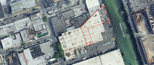
154 Morgan Ave
02967-0001
DOCID-2019090601032003ADDL BLK-LOT: 2974-1
Warehouse
Kings
AE
New York
3604970208F
50
2024
2.58 AC
2025
North Brooklyn
044300
Long Island (New York)
85,000 SF
New York-Jersey City-White Plains, NY-NJ
DEMOGRAPHICS near 154 Morgan Ave
1 mile
3 mile
5 mile
2024 Total Population
117,073
1,103,272
3,262,169
2029 Population
111,438
1,041,171
3,058,481
Pop Growth 2024-2029
(4.81%)
(5.63%)
(6.24%)
Average Age
36
37
39
2024 Total Households
46,439
443,501
1,361,576
HH Growth 2024-2029
(5.43%)
(5.98%)
(6.51%)
Median Household Inc
$74,229
$77,437
$83,871
Avg Household Size
2.40
2.40
2.30
2024 Avg HH Vehicles
.00
.00
.00
Median Home Value
$883,020
$865,541
$847,129
Median Year Built
1955
1949
1950
Nearby Places
Map Layers
Map Styles
 Street
 Aerial
Transit
 Traffic
 Biking
Places
Listings with unknown addresses are not visible on the map
- Restaurants
- Banks
- Shops
- Fitness
- Groceries
PUBLIC TRANSPORTATION
TRANSIT/SUBWAY
Morgan Avenue (L - New York MTA Subway (The Subway))
Drive
Walk
Distance
Morgan Avenue (L - New York MTA Subway (The Subway))
1 min
5 min
0.3 mi
Montrose Avenue (L - New York MTA Subway (The Subway))
Drive
Walk
Distance
Montrose Avenue (L - New York MTA Subway (The Subway))
2 min
8 min
0.4 mi
Grand Street (L Line) (L - New York MTA Subway (The Subway))
Drive
Walk
Distance
Grand Street (L Line) (L - New York MTA Subway (The Subway))
2 min
11 min
0.6 mi
Jefferson Street (L - New York MTA Subway (The Subway))
Drive
Walk
Distance
Jefferson Street (L - New York MTA Subway (The Subway))
2 min
13 min
0.7 mi
Graham Avenue (L - New York MTA Subway (The Subway))
Drive
Walk
Distance
Graham Avenue (L - New York MTA Subway (The Subway))
2 min
16 min
0.8 mi
COMMUTER RAIL
Nostrand Avenue Station (Far Rockaway Branch - Long Island Rail Road, Hempstead Branch - Long Island Rail Road, Long Beach Branch - Long Island Rail Road, West Hempstead Branch - Long Island Rail Road)
Drive
Walk
Distance
Nostrand Avenue Station (Far Rockaway Branch - Long Island Rail Road, Hempstead Branch - Long Island Rail Road, Long Beach Branch - Long Island Rail Road, West Hempstead Branch - Long Island Rail Road)
10 min
3.2 mi
Hunterspoint Avenue Station (Hempstead Branch - Long Island Rail Road, Oyster Bay Branch - Long Island Rail Road)
Drive
Walk
Distance
Hunterspoint Avenue Station (Hempstead Branch - Long Island Rail Road, Oyster Bay Branch - Long Island Rail Road)
8 min
3.3 mi
AIRPORT
LaGuardia
Drive
Walk
Distance
LaGuardia
14 min
6.9 mi
John F Kennedy International
Drive
Walk
Distance
John F Kennedy International
21 min
12.1 mi
Newark Liberty International
Drive
Walk
Distance
Newark Liberty International
29 min
15.9 mi
Freight Ports
NY - Red Hook Container Terminal
Drive
Walk
Distance
NY - Red Hook Container Terminal
12 min
5.9 mi
Nearby Properties
Address
Land Use
TOTAL SIZE
Lot Size
Zoning
Address
Land Use
TOTAL SIZE
Lot Size
Zoning
8,462,176 SF
61.41 AC
R7-2
Address
Land Use
TOTAL SIZE
Lot Size
Zoning
2,812,739 SF
2.10 AC
C5-3
Address
Land Use
TOTAL SIZE
Lot Size
Zoning
1,104,505 SF
2.32 AC
C4-7
Address
Land Use
TOTAL SIZE
Lot Size
Zoning
7,058,736 SF
147.61 AC
M3-1
Address
Land Use
TOTAL SIZE
Lot Size
Zoning
869,038 SF
1.53 AC
M1-1
Address
Land Use
TOTAL SIZE
Lot Size
Zoning
1,065,915 SF
2.13 AC
M16R10
Address
Land Use
TOTAL SIZE
Lot Size
Zoning
986,641 SF
6.74 AC
R8
Address
Land Use
TOTAL SIZE
Lot Size
Zoning
986,641 SF
6.74 AC
R8
Address
Land Use
TOTAL SIZE
Lot Size
Zoning
986,641 SF
6.74 AC
R8
Address
Land Use
TOTAL SIZE
Lot Size
Zoning
986,641 SF
6.74 AC
R8
Address
Land Use
TOTAL SIZE
Lot Size
Zoning
986,641 SF
6.74 AC
R8
Address
Land Use
TOTAL SIZE
Lot Size
Zoning
986,641 SF
6.74 AC
R8
Address
Land Use
TOTAL SIZE
Lot Size
Zoning
986,641 SF
6.74 AC
R8
Address
Land Use
TOTAL SIZE
Lot Size
Zoning
986,641 SF
6.74 AC
R8
Address
Land Use
TOTAL SIZE
Lot Size
Zoning
986,641 SF
6.74 AC
R8
Address
Land Use
TOTAL SIZE
Lot Size
Zoning
986,641 SF
6.74 AC
R8
Address
Land Use
TOTAL SIZE
Lot Size
Zoning
986,641 SF
6.74 AC
R8
Address
Land Use
TOTAL SIZE
Lot Size
Zoning
986,641 SF
6.74 AC
R8
Address
Land Use
TOTAL SIZE
Lot Size
Zoning
986,641 SF
6.74 AC
R8
Address
Land Use
TOTAL SIZE
Lot Size
Zoning
986,641 SF
6.74 AC
R8
Address
Land Use
TOTAL SIZE
Lot Size
Zoning
986,641 SF
6.74 AC
R8
Address
Land Use
TOTAL SIZE
Lot Size
Zoning
986,641 SF
6.74 AC
R8
Address
Land Use
TOTAL SIZE
Lot Size
Zoning
986,641 SF
6.74 AC
R8
Address
Land Use
TOTAL SIZE
Lot Size
Zoning
986,641 SF
6.74 AC
R8
Address
Land Use
TOTAL SIZE
Lot Size
Zoning
986,641 SF
6.74 AC
R8
Address
Land Use
TOTAL SIZE
Lot Size
Zoning
986,641 SF
6.74 AC
R8
Address
Land Use
TOTAL SIZE
Lot Size
Zoning
986,641 SF
6.74 AC
R8
Address
Land Use
TOTAL SIZE
Lot Size
Zoning
986,641 SF
6.74 AC
R8
Address
Land Use
TOTAL SIZE
Lot Size
Zoning
986,641 SF
6.74 AC
R8
Address
Land Use
TOTAL SIZE
Lot Size
Zoning
986,641 SF
6.74 AC
R8
The World's #1 Commercial Real Estate Marketplace
Connect with us
© 2026 CoStar Group
The information above has been obtained from sources believed reliable. While we do not doubt its accuracy we have not verified it and make no guarantee, warranty or representation about it. It is your responsibility to independently confirm its accuracy and completeness. Any projections, opinions, assumptions, or estimates used are for example only and do not represent the current or future performance of the property. The value of this transaction to you depends on tax and other factors which should be evaluated by your tax, financial, and legal advisors. You and your advisors should conduct a careful, independent investigation of the property to determine to your satisfaction the suitability of the property for your needs.