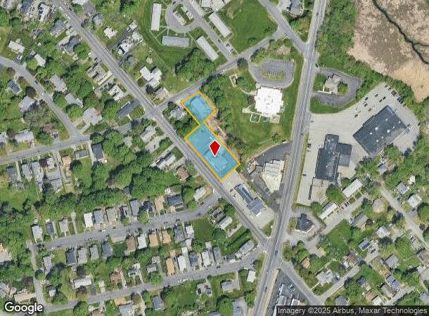
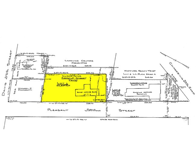
Property Record
160 Pleasant St, North Andover, MA 01845

NEARBY LISTINGS FOR SALE OR LEASE
Property Detail
160 Pleasant St
Commercialnec
Essex
X
Massachusetts
25009C0228G
0.60 AC
2025
Lawrence/Andover
2025
Boston
253100
Boston-Cambridge-Newton, MA-NH
3,200 SF
NAND-000700-000018
DEMOGRAPHICS near 160 Pleasant St
1 Mile
3 Mile
5 Mile
2024 Total Population
12,243
112,006
191,689
2029 Population
12,274
110,283
188,981
Pop Growth 2024-2029
+ 0.25%
(1.54%)
(1.41%)
Average Age
41
38
38
2024 Total Households
5,119
39,029
67,183
HH Growth 2024-2029
+ 0.12%
(1.39%)
(1.35%)
Median Household Inc
$98,428
$67,087
$78,226
Avg Household Size
2.30
2.70
2.70
2024 Avg HH Vehicles
2.00
2.00
2.00
Median Home Value
$483,473
$458,893
$470,054
Median Year Built
1962
1958
1964
Nearby Places
- Restaurants
- Banks
- Shops
- Fitness
- Groceries
PUBLIC TRANSPORTATION
COMMUTER RAIL
Lawrence (Haverhill Line - Massachusetts Bay Transportation Authority Commuter Rail (Purple Line))
DRIVE
WALK
Distance
Lawrence (Haverhill Line - Massachusetts Bay Transportation Authority Commuter Rail (Purple Line))
6 min
2.2 mi
Andover (Haverhill Line - Massachusetts Bay Transportation Authority Commuter Rail (Purple Line))
DRIVE
WALK
Distance
Andover (Haverhill Line - Massachusetts Bay Transportation Authority Commuter Rail (Purple Line))
7 min
3.3 mi
AIRPORT
Manchester Boston Regional
DRIVE
WALK
Distance
Manchester Boston Regional
48 min
29.1 mi
General Edward Lawrence Logan International
DRIVE
WALK
Distance
General Edward Lawrence Logan International
43 min
29.3 mi
Portsmouth International at Pease
DRIVE
WALK
Distance
Portsmouth International at Pease
52 min
38.1 mi
Nearby Properties
Address
Land Use
TOTAL SIZE
Lot Size
Zoning
Address
Land Use
TOTAL SIZE
Lot Size
Zoning
110.12 AC
I2
Address
Land Use
TOTAL SIZE
Lot Size
Zoning
102 AC
IA
Address
Land Use
TOTAL SIZE
Lot Size
Zoning
6,680 SF
84.07 AC
R2
Address
Land Use
TOTAL SIZE
Lot Size
Zoning
9,576 SF
56.95 AC
R3
Address
Land Use
TOTAL SIZE
Lot Size
Zoning
10.38 AC
Address
Land Use
TOTAL SIZE
Lot Size
Zoning
3,111 SF
42.18 AC
R5
Address
Land Use
TOTAL SIZE
Lot Size
Zoning
9.28 AC
I2
Address
Land Use
TOTAL SIZE
Lot Size
Zoning
9,966 SF
67.03 AC
R2
Address
Land Use
TOTAL SIZE
Lot Size
Zoning
15,621 SF
34 AC
R5
Address
Land Use
TOTAL SIZE
Lot Size
Zoning
204,300 SF
5.48 AC
Address
Land Use
TOTAL SIZE
Lot Size
Zoning
335,482 SF
7.61 AC
Address
Land Use
TOTAL SIZE
Lot Size
Zoning
240,639 SF
2.65 AC
Address
Land Use
TOTAL SIZE
Lot Size
Zoning
16.56 AC
Address
Land Use
TOTAL SIZE
Lot Size
Zoning
170,116 SF
11.14 AC
Address
Land Use
TOTAL SIZE
Lot Size
Zoning
8.59 AC
IS
Address
Land Use
TOTAL SIZE
Lot Size
Zoning
71,785 SF
29 AC
R4
Address
Land Use
TOTAL SIZE
Lot Size
Zoning
332,500 SF
3.17 AC
Address
Land Use
TOTAL SIZE
Lot Size
Zoning
7.13 AC
Address
Land Use
TOTAL SIZE
Lot Size
Zoning
8,738 SF
30.59 AC
R4
Address
Land Use
TOTAL SIZE
Lot Size
Zoning
Address
Land Use
TOTAL SIZE
Lot Size
Zoning
0.13 AC
MU
Address
Land Use
TOTAL SIZE
Lot Size
Zoning
208,600 SF
2.42 AC
Address
Land Use
TOTAL SIZE
Lot Size
Zoning
6.84 AC
Address
Land Use
TOTAL SIZE
Lot Size
Zoning
185,046 SF
3.06 AC
Address
Land Use
TOTAL SIZE
Lot Size
Zoning
2,552 SF
14.23 AC
Address
Land Use
TOTAL SIZE
Lot Size
Zoning
9,920 SF
3.24 AC
B2
Address
Land Use
TOTAL SIZE
Lot Size
Zoning
205,305 SF
1.94 AC
Address
Land Use
TOTAL SIZE
Lot Size
Zoning
124,750 SF
1.53 AC
Address
Land Use
TOTAL SIZE
Lot Size
Zoning
260,720 SF
57.68 AC
I2
Address
Land Use
TOTAL SIZE
Lot Size
Zoning
3,462 SF
8.14 AC
The World's #1 Commercial Real Estate Marketplace
Connect with us
© 2025 CoStar Group
The information above has been obtained from sources believed reliable. While we do not doubt its accuracy we have not verified it and make no guarantee, warranty or representation about it. It is your responsibility to independently confirm its accuracy and completeness. Any projections, opinions, assumptions, or estimates used are for example only and do not represent the current or future performance of the property. The value of this transaction to you depends on tax and other factors which should be evaluated by your tax, financial, and legal advisors. You and your advisors should conduct a careful, independent investigation of the property to determine to your satisfaction the suitability of the property for your needs.