Property Record
154 Richardson Dr, Vallejo, CA 94589
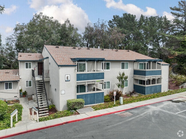


Property Detail
154 Richardson Dr
Vallejo, CA
STRAWBERRY HILL SUB LOT 1
0052-382-020
Solano
Multifamilydwelling
California
B and X Area of moderate flood hazard, usually the area between the limits of the 100-year and 500-year floods.
1
2024
4.40 AC
2025
West Vallejo
251901
North Bay/Santa Rosa
49,896 SF
NEARBY LISTINGS FOR SALE OR LEASE
DEMOGRAPHICS near 154 Richardson Dr
1 mile
3 mile
5 mile
2025 Total Population
16,032
111,754
153,487
2030 Population
16,225
112,195
154,116
Pop Growth 2025-2030
+ 1.20%
+ 0.39%
+ 0.41%
Average Age
42
41
41
2025 Total Households
5,845
37,525
51,880
HH Growth 2025-2030
+ 1.39%
+ 0.52%
+ 0.53%
Median Household Inc
$66,357
$86,459
$94,548
Avg Household Size
2.60
2.90
2.80
2025 Avg HH Vehicles
2.00
2.00
2.00
Median Home Value
$586,659
$640,438
$668,758
Median Year Built
1971
1971
1976
Nearby Places
Map Layers
Map Styles
 Street
 Aerial
Layers
 Traffic
 Biking
Places
Listings with unknown addresses are not visible on the map
- Restaurants
- Banks
- Shops
- Fitness
- Groceries
PUBLIC TRANSPORTATION
AIRPORT
Metro Oakland International
Drive
Walk
Distance
Metro Oakland International
49 min
37.4 mi
Freight Ports
Port of Richmond
Drive
Walk
Distance
Port of Richmond
34 min
23.1 mi
Nearby Properties
Address
Land Use
TOTAL SIZE
Lot Size
Zoning
Address
Land Use
TOTAL SIZE
Lot Size
Zoning
432,550 SF
29.70 AC
Address
Land Use
TOTAL SIZE
Lot Size
Zoning
108.37 AC
Address
Land Use
TOTAL SIZE
Lot Size
Zoning
349.61 AC
Address
Land Use
TOTAL SIZE
Lot Size
Zoning
92,043 SF
8.99 AC
Address
Land Use
TOTAL SIZE
Lot Size
Zoning
165,000 SF
8.63 AC
Address
Land Use
TOTAL SIZE
Lot Size
Zoning
123,566 SF
7.17 AC
Address
Land Use
TOTAL SIZE
Lot Size
Zoning
176,119 SF
6.80 AC
CHANGE-MUL
Address
Land Use
TOTAL SIZE
Lot Size
Zoning
266,792 SF
26.29 AC
Address
Land Use
TOTAL SIZE
Lot Size
Zoning
80,512 SF
6.88 AC
Address
Land Use
TOTAL SIZE
Lot Size
Zoning
4.23 AC
COMM
Address
Land Use
TOTAL SIZE
Lot Size
Zoning
128,544 SF
5.92 AC
Address
Land Use
TOTAL SIZE
Lot Size
Zoning
175,831 SF
8.63 AC
Address
Land Use
TOTAL SIZE
Lot Size
Zoning
240,905 SF
19.12 AC
Address
Land Use
TOTAL SIZE
Lot Size
Zoning
108,316 SF
5.31 AC
MULTI RES
Address
Land Use
TOTAL SIZE
Lot Size
Zoning
121,070 SF
11.12 AC
Address
Land Use
TOTAL SIZE
Lot Size
Zoning
27,653 SF
3.85 AC
Address
Land Use
TOTAL SIZE
Lot Size
Zoning
73,819 SF
5.64 AC
Address
Land Use
TOTAL SIZE
Lot Size
Zoning
178,265 SF
10.87 AC
Address
Land Use
TOTAL SIZE
Lot Size
Zoning
266,792 SF
3.32 AC
Address
Land Use
TOTAL SIZE
Lot Size
Zoning
4.99 AC
Address
Land Use
TOTAL SIZE
Lot Size
Zoning
46,912 SF
9.36 AC
Address
Land Use
TOTAL SIZE
Lot Size
Zoning
119,746 SF
0.64 AC
Address
Land Use
TOTAL SIZE
Lot Size
Zoning
83,768 SF
4.08 AC
Address
Land Use
TOTAL SIZE
Lot Size
Zoning
125,720 SF
11.72 AC
Address
Land Use
TOTAL SIZE
Lot Size
Zoning
140,712 SF
9.54 AC
Address
Land Use
TOTAL SIZE
Lot Size
Zoning
126,000 SF
12.60 AC
GENERAL RE
Address
Land Use
TOTAL SIZE
Lot Size
Zoning
55,537 SF
7.84 AC
COMMERCIAL
Address
Land Use
TOTAL SIZE
Lot Size
Zoning
86,116 SF
4.64 AC
Address
Land Use
TOTAL SIZE
Lot Size
Zoning
82,058 SF
6.45 AC
Address
Land Use
TOTAL SIZE
Lot Size
Zoning
150,719 SF
14.16 AC
The World's #1 Commercial Real Estate Marketplace
Connect with us
© 2026 CoStar Group
The information above has been obtained from sources believed reliable. While we do not doubt its accuracy we have not verified it and make no guarantee, warranty or representation about it. It is your responsibility to independently confirm its accuracy and completeness. Any projections, opinions, assumptions, or estimates used are for example only and do not represent the current or future performance of the property. The value of this transaction to you depends on tax and other factors which should be evaluated by your tax, financial, and legal advisors. You and your advisors should conduct a careful, independent investigation of the property to determine to your satisfaction the suitability of the property for your needs.