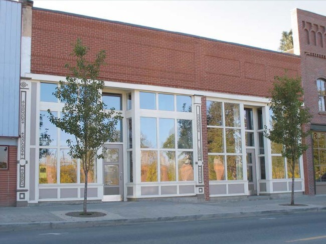
Property Record
154 S Main St, Independence, OR 97351

Property Detail
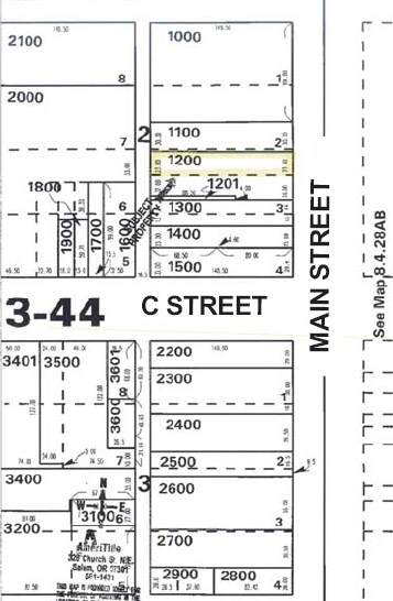
154 S Main St
202828
RESTAURANT - TAVERN
Officebuilding
Polk
MUPC
Oregon
B and X Area of moderate flood hazard, usually the area between the limits of the 100-year and 500-year floods.
0.17 AC
2025
Polk County
2026
Portland
020305
Salem, OR
6,528 SF
NEARBY LISTINGS FOR SALE OR LEASE
DEMOGRAPHICS near 154 S Main St
1 mile
3 mile
5 mile
2025 Total Population
6,705
23,798
26,492
2030 Population
6,736
24,288
26,996
Pop Growth 2025-2030
+ 0.46%
+ 2.06%
+ 1.90%
Average Age
36
35
36
2025 Total Households
2,207
7,952
8,933
HH Growth 2025-2030
+ 0.54%
+ 2.13%
+ 1.95%
Median Household Inc
$91,119
$77,113
$80,736
Avg Household Size
3.00
2.80
2.80
2025 Avg HH Vehicles
2.00
2.00
2.00
Median Home Value
$375,496
$397,639
$422,806
Median Year Built
1989
1995
1994
Nearby Places
Map Layers
Map Styles
 Street
 Aerial
Layers
 Traffic
 Biking
Places
Listings with unknown addresses are not visible on the map
- Restaurants
- Banks
- Shops
- Fitness
- Groceries
Nearby Properties
Address
Land Use
TOTAL SIZE
Lot Size
Zoning
Address
Land Use
TOTAL SIZE
Lot Size
Zoning
110,491 SF
8.24 AC
PSC
Address
Land Use
TOTAL SIZE
Lot Size
Zoning
10 SF
32.46 AC
PSC
Address
Land Use
TOTAL SIZE
Lot Size
Zoning
10 SF
14.45 AC
PSC
Address
Land Use
TOTAL SIZE
Lot Size
Zoning
216,688 SF
16.43 AC
PS
Address
Land Use
TOTAL SIZE
Lot Size
Zoning
22,385 SF
7.28 AC
PSC
Address
Land Use
TOTAL SIZE
Lot Size
Zoning
98,870 SF
2.50 AC
PSC
Address
Land Use
TOTAL SIZE
Lot Size
Zoning
94,783 SF
15.86 AC
PS
Address
Land Use
TOTAL SIZE
Lot Size
Zoning
65,155 SF
4.09 AC
RH
Address
Land Use
TOTAL SIZE
Lot Size
Zoning
10 SF
2.50 AC
PSC
Address
Land Use
TOTAL SIZE
Lot Size
Zoning
195,605 SF
10.13 AC
MUPC
Address
Land Use
TOTAL SIZE
Lot Size
Zoning
6,322 SF
9.88 AC
PSC
Address
Land Use
TOTAL SIZE
Lot Size
Zoning
541,879 SF
3.52 AC
RH
Address
Land Use
TOTAL SIZE
Lot Size
Zoning
201,840 SF
15.43 AC
RM
Address
Land Use
TOTAL SIZE
Lot Size
Zoning
58,305 SF
41.98 AC
PS
Address
Land Use
TOTAL SIZE
Lot Size
Zoning
18,639 SF
30.81 AC
RM
Address
Land Use
TOTAL SIZE
Lot Size
Zoning
10 SF
5.84 AC
RMX
Address
Land Use
TOTAL SIZE
Lot Size
Zoning
43,319 SF
1.80 AC
PS
Address
Land Use
TOTAL SIZE
Lot Size
Zoning
10 SF
2.50 AC
PSC
Address
Land Use
TOTAL SIZE
Lot Size
Zoning
10 SF
23.37 AC
IL
Address
Land Use
TOTAL SIZE
Lot Size
Zoning
159,089 SF
3.26 AC
IH
Address
Land Use
TOTAL SIZE
Lot Size
Zoning
60,113 SF
4.24 AC
PS
Address
Land Use
TOTAL SIZE
Lot Size
Zoning
41,314 SF
8.01 AC
CR
Address
Land Use
TOTAL SIZE
Lot Size
Zoning
159,089 SF
1.94 AC
IH
Address
Land Use
TOTAL SIZE
Lot Size
Zoning
18,896 SF
1.17 AC
CRD
Address
Land Use
TOTAL SIZE
Lot Size
Zoning
48,242 SF
2.32 AC
CH
Address
Land Use
TOTAL SIZE
Lot Size
Zoning
71,956 SF
6.08 AC
RS
Address
Land Use
TOTAL SIZE
Lot Size
Zoning
63,560 SF
2.83 AC
RM
Address
Land Use
TOTAL SIZE
Lot Size
Zoning
76,852 SF
8.55 AC
MUPC
Address
Land Use
TOTAL SIZE
Lot Size
Zoning
46,880 SF
13.54 AC
PSC
Address
Land Use
TOTAL SIZE
Lot Size
Zoning
13,792 SF
1.83 AC
CO
The World's #1 Commercial Real Estate Marketplace
Connect with us
© 2026 CoStar Group
The information above has been obtained from sources believed reliable. While we do not doubt its accuracy we have not verified it and make no guarantee, warranty or representation about it. It is your responsibility to independently confirm its accuracy and completeness. Any projections, opinions, assumptions, or estimates used are for example only and do not represent the current or future performance of the property. The value of this transaction to you depends on tax and other factors which should be evaluated by your tax, financial, and legal advisors. You and your advisors should conduct a careful, independent investigation of the property to determine to your satisfaction the suitability of the property for your needs.