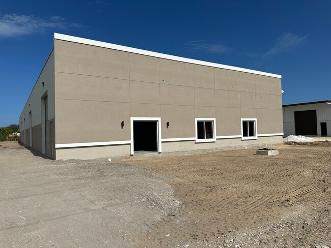
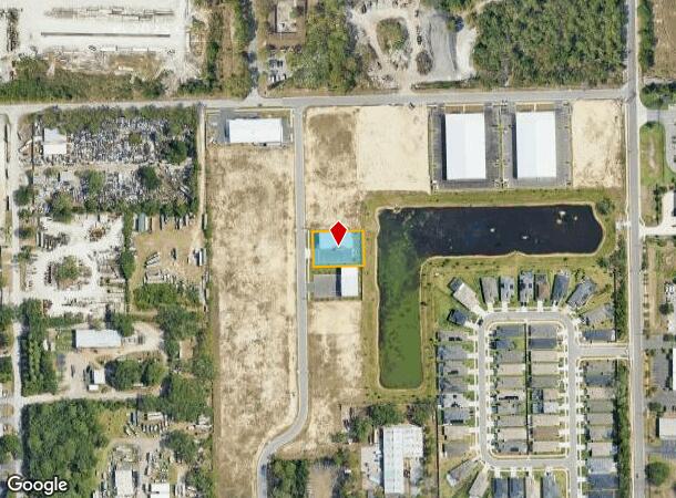
Property Record
1567 Northbend Dr, Tarpon Springs, FL 34689
Current Lease Availabilities
NEARBY LISTINGS FOR SALE OR LEASE
Property Detail
1567 Northbend Dr
Tampa-St. Petersburg-Clearwater, FL
River Bend Village
02-27-15-75760-002-0150
RIVER BEND VILLAGE BLK 2, LOT 15
Warehouse
Pinellas
AE
Florida
12103C0019H
15
2024
0.40 AC
2025
North Pinellas
027308
Tampa/St Petersburg
5,198 SF
DEMOGRAPHICS near 1567 Northbend Dr
1 Mile
3 Mile
5 Mile
2024 Total Population
6,348
60,932
114,195
2029 Population
6,851
66,285
124,104
Pop Growth 2024-2029
+ 7.92%
+ 8.79%
+ 8.68%
Average Age
46
45
45
2024 Total Households
2,701
26,556
49,180
HH Growth 2024-2029
+ 7.70%
+ 8.49%
+ 8.30%
Median Household Inc
$57,161
$56,202
$63,539
Avg Household Size
2.30
2.20
2.30
2024 Avg HH Vehicles
2.00
2.00
2.00
Median Home Value
$307,944
$291,411
$320,164
Median Year Built
1985
1978
1978
Nearby Places
- Restaurants
- Banks
- Shops
- Fitness
- Groceries
PUBLIC TRANSPORTATION
AIRPORT
Tampa International
DRIVE
WALK
Distance
Tampa International
45 min
25.4 mi
St Pete-Clearwater International
DRIVE
WALK
Distance
St Pete-Clearwater International
45 min
25.6 mi
Freight Ports
Port of Tampa Bay
DRIVE
WALK
Distance
Port of Tampa Bay
59 min
33.9 mi
Nearby Properties
Address
Land Use
TOTAL SIZE
Lot Size
Zoning
Address
Land Use
TOTAL SIZE
Lot Size
Zoning
341,775 SF
43.99 AC
Address
Land Use
TOTAL SIZE
Lot Size
Zoning
214,040 SF
8.47 AC
Address
Land Use
TOTAL SIZE
Lot Size
Zoning
286,598 SF
6.56 AC
Address
Land Use
TOTAL SIZE
Lot Size
Zoning
202,954 SF
49.22 AC
AR
Address
Land Use
TOTAL SIZE
Lot Size
Zoning
333,044 SF
25.64 AC
R4
Address
Land Use
TOTAL SIZE
Lot Size
Zoning
154,033 SF
15.86 AC
Address
Land Use
TOTAL SIZE
Lot Size
Zoning
157,476 SF
27.47 AC
MPUD
Address
Land Use
TOTAL SIZE
Lot Size
Zoning
264.64 AC
AC
Address
Land Use
TOTAL SIZE
Lot Size
Zoning
151,825 SF
18.01 AC
Address
Land Use
TOTAL SIZE
Lot Size
Zoning
145,216 SF
7.58 AC
MF3
Address
Land Use
TOTAL SIZE
Lot Size
Zoning
131,819 SF
11.24 AC
Address
Land Use
TOTAL SIZE
Lot Size
Zoning
81,053 SF
9.52 AC
Address
Land Use
TOTAL SIZE
Lot Size
Zoning
121,869 SF
4.72 AC
C2
Address
Land Use
TOTAL SIZE
Lot Size
Zoning
141,763 SF
12.96 AC
Address
Land Use
TOTAL SIZE
Lot Size
Zoning
81,045 SF
16.34 AC
PUD
Address
Land Use
TOTAL SIZE
Lot Size
Zoning
67,179 SF
9.52 AC
Address
Land Use
TOTAL SIZE
Lot Size
Zoning
80,212 SF
6.64 AC
Address
Land Use
TOTAL SIZE
Lot Size
Zoning
77,716 SF
2.54 AC
Address
Land Use
TOTAL SIZE
Lot Size
Zoning
203,135 SF
41.04 AC
C2
Address
Land Use
TOTAL SIZE
Lot Size
Zoning
143,430 SF
8.68 AC
Address
Land Use
TOTAL SIZE
Lot Size
Zoning
87,794 SF
7.97 AC
Address
Land Use
TOTAL SIZE
Lot Size
Zoning
70,901 SF
5.70 AC
Address
Land Use
TOTAL SIZE
Lot Size
Zoning
66.18 AC
RPD5
Address
Land Use
TOTAL SIZE
Lot Size
Zoning
44,321 SF
9.65 AC
Address
Land Use
TOTAL SIZE
Lot Size
Zoning
59,196 SF
4.41 AC
Address
Land Use
TOTAL SIZE
Lot Size
Zoning
77,384 SF
6.32 AC
Address
Land Use
TOTAL SIZE
Lot Size
Zoning
72,796 SF
2.62 AC
MF3
Address
Land Use
TOTAL SIZE
Lot Size
Zoning
65,939 SF
7.23 AC
C2
Address
Land Use
TOTAL SIZE
Lot Size
Zoning
90,892 SF
8.80 AC
Address
Land Use
TOTAL SIZE
Lot Size
Zoning
40.42 AC
The World's #1 Commercial Real Estate Marketplace
Connect with us
© 2025 CoStar Group
The information above has been obtained from sources believed reliable. While we do not doubt its accuracy we have not verified it and make no guarantee, warranty or representation about it. It is your responsibility to independently confirm its accuracy and completeness. Any projections, opinions, assumptions, or estimates used are for example only and do not represent the current or future performance of the property. The value of this transaction to you depends on tax and other factors which should be evaluated by your tax, financial, and legal advisors. You and your advisors should conduct a careful, independent investigation of the property to determine to your satisfaction the suitability of the property for your needs.