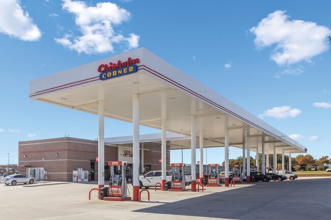
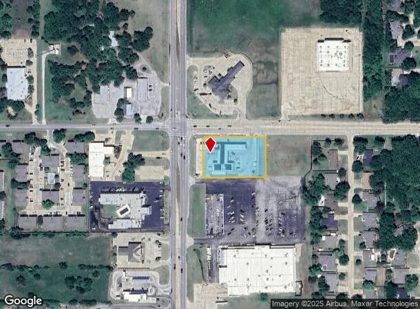
Property Record
1524 W Plato Rd, Duncan, OK 73533

NEARBY LISTINGS FOR SALE OR LEASE
Property Detail
1524 W Plato Rd
Duncan, OK
Wal-Mart Center
1588-00-000-003-0-000-00
TRACT 2 & 3, WAL-MART CENTER (FINAL PLAT OF WAL-MART SUBDIVISION DUNCAN OK) (TRACT 2 OF WAL-MART CENTER-FINAL PLAT WAL-MART S
Conveniencestore
Stephens
X
Oklahoma
40137C0215F
2
2024
1.29 AC
2025
Oklahoma West Area
000200
Other Market Areas
4,141 SF
DEMOGRAPHICS near 1524 W Plato Rd
1 Mile
3 Mile
5 Mile
2024 Total Population
4,404
21,397
25,812
2029 Population
4,552
22,246
26,866
Pop Growth 2024-2029
+ 3.36%
+ 3.97%
+ 4.08%
Average Age
46
41
42
2024 Total Households
1,926
8,747
10,522
HH Growth 2024-2029
+ 3.22%
+ 3.83%
+ 3.93%
Median Household Inc
$76,002
$52,039
$51,448
Avg Household Size
2.20
2.30
2.40
2024 Avg HH Vehicles
2.00
2.00
2.00
Median Home Value
$185,914
$134,078
$134,133
Median Year Built
1979
1970
1971
Nearby Places
Map Layers
Map Styles
 Street
 Aerial
- Restaurants
- Banks
- Shops
- Fitness
- Groceries
PUBLIC TRANSPORTATION
AIRPORT
Lawton-Fort Sill Regional
DRIVE
WALK
Distance
Lawton-Fort Sill Regional
45 min
32.3 mi
SALE & LEASE HISTORY
LISTING DATE
SALE/LEASE

Dec 20, 2022
For Sale
Nearby Properties
Address
Land Use
TOTAL SIZE
Lot Size
Zoning
Address
Land Use
TOTAL SIZE
Lot Size
Zoning
4,064 SF
43.23 AC
Address
Land Use
TOTAL SIZE
Lot Size
Zoning
127,660 SF
20 AC
Address
Land Use
TOTAL SIZE
Lot Size
Zoning
63,093 SF
23.46 AC
Address
Land Use
TOTAL SIZE
Lot Size
Zoning
34,192 SF
80.31 AC
Address
Land Use
TOTAL SIZE
Lot Size
Zoning
9,694 SF
5.12 AC
C2
Address
Land Use
TOTAL SIZE
Lot Size
Zoning
825 SF
97.38 AC
Address
Land Use
TOTAL SIZE
Lot Size
Zoning
61,546 SF
22.70 AC
Address
Land Use
TOTAL SIZE
Lot Size
Zoning
82,956 SF
11.54 AC
C1
Address
Land Use
TOTAL SIZE
Lot Size
Zoning
32,998 SF
2.64 AC
C2
Address
Land Use
TOTAL SIZE
Lot Size
Zoning
260 SF
1.93 AC
R1
Address
Land Use
TOTAL SIZE
Lot Size
Zoning
816 SF
8 AC
C2
Address
Land Use
TOTAL SIZE
Lot Size
Zoning
7,478 SF
1.26 AC
R1
Address
Land Use
TOTAL SIZE
Lot Size
Zoning
160 SF
43.16 AC
Address
Land Use
TOTAL SIZE
Lot Size
Zoning
30,841 SF
3.12 AC
R1
Address
Land Use
TOTAL SIZE
Lot Size
Zoning
1,500 SF
5 AC
C2
Address
Land Use
TOTAL SIZE
Lot Size
Zoning
25,732 SF
20 AC
C1
Address
Land Use
TOTAL SIZE
Lot Size
Zoning
9,014 SF
1.77 AC
C1
Address
Land Use
TOTAL SIZE
Lot Size
Zoning
61,514 SF
2.34 AC
C1
Address
Land Use
TOTAL SIZE
Lot Size
Zoning
33,953 SF
5.94 AC
R1
Address
Land Use
TOTAL SIZE
Lot Size
Zoning
18,492 SF
9.89 AC
C1
Address
Land Use
TOTAL SIZE
Lot Size
Zoning
14,352 SF
10 AC
R1
Address
Land Use
TOTAL SIZE
Lot Size
Zoning
20,966 SF
5 AC
R1
Address
Land Use
TOTAL SIZE
Lot Size
Zoning
2,400 SF
2.75 AC
R1
Address
Land Use
TOTAL SIZE
Lot Size
Zoning
900 SF
1.74 AC
C2
Address
Land Use
TOTAL SIZE
Lot Size
Zoning
38,723 SF
5.62 AC
R1
Address
Land Use
TOTAL SIZE
Lot Size
Zoning
13,770 SF
3.55 AC
R1
Address
Land Use
TOTAL SIZE
Lot Size
Zoning
4,000 SF
76.61 AC
C1
Address
Land Use
TOTAL SIZE
Lot Size
Zoning
1,099 SF
6 AC
R1
Address
Land Use
TOTAL SIZE
Lot Size
Zoning
8,137 SF
7.57 AC
R1
Address
Land Use
TOTAL SIZE
Lot Size
Zoning
9,532 SF
1.90 AC
R1
The World's #1 Commercial Real Estate Marketplace
Connect with us
© 2026 CoStar Group
The information above has been obtained from sources believed reliable. While we do not doubt its accuracy we have not verified it and make no guarantee, warranty or representation about it. It is your responsibility to independently confirm its accuracy and completeness. Any projections, opinions, assumptions, or estimates used are for example only and do not represent the current or future performance of the property. The value of this transaction to you depends on tax and other factors which should be evaluated by your tax, financial, and legal advisors. You and your advisors should conduct a careful, independent investigation of the property to determine to your satisfaction the suitability of the property for your needs.