Property Record
1540 S Logan St, Mishawaka, IN 46544

NEARBY LISTINGS FOR SALE OR LEASE
Property Detail
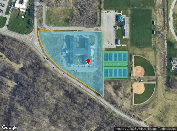
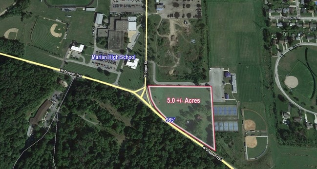
1540 S Logan St
71-09-21-151-001.000-022
S END W 1/2 W 1/2 NW N OF RD 5 ACRES SEC 21-37-3E
Hospitalprivate
St Joseph
X
Indiana
18141C0214D
5 AC
2023
Mishawaka
2024
South Bend/Mishawaka
010201
South Bend-Mishawaka, IN-MI
112,424 SF
DEMOGRAPHICS near 1540 S Logan St
1 Mile
3 Mile
5 Mile
2024 Total Population
8,179
77,245
150,781
2029 Population
8,191
77,085
151,014
Pop Growth 2024-2029
+ 0.15%
(0.21%)
+ 0.15%
Average Age
39
39
38
2024 Total Households
3,381
32,911
60,441
HH Growth 2024-2029
+ 0.24%
(0.22%)
+ 0.15%
Median Household Inc
$45,412
$53,060
$53,072
Avg Household Size
2.30
2.20
2.20
2024 Avg HH Vehicles
2.00
2.00
2.00
Median Home Value
$94,109
$128,140
$142,374
Median Year Built
1957
1958
1963
Nearby Places
Map Layers
Map Styles
 Street
 Aerial
- Restaurants
- Banks
- Shops
- Fitness
- Groceries
PUBLIC TRANSPORTATION
COMMUTER RAIL
South Bend Amtrak Station (Capitol Limited - Amtrak, Lake Shore Limited - Amtrak)
DRIVE
WALK
Distance
South Bend Amtrak Station (Capitol Limited - Amtrak, Lake Shore Limited - Amtrak)
13 min
6.6 mi
South Bend Airport Station (South Shore Line - Northern Indiana Commuter Transportation District (South Shore Line))
DRIVE
WALK
Distance
South Bend Airport Station (South Shore Line - Northern Indiana Commuter Transportation District (South Shore Line))
17 min
8.4 mi
AIRPORT
South Bend International
DRIVE
WALK
Distance
South Bend International
26 min
10.6 mi
Freight Ports
Port Milwaukee
DRIVE
WALK
Distance
Port Milwaukee
228 min
179.7 mi
SALE & LEASE HISTORY
LISTING DATE
SALE/LEASE

Jun 20, 2017
For Sale
Nearby Properties
Address
Land Use
TOTAL SIZE
Lot Size
Zoning
Address
Land Use
TOTAL SIZE
Lot Size
Zoning
630,870 SF
0.01 AC
Address
Land Use
TOTAL SIZE
Lot Size
Zoning
397,501 SF
3.50 AC
Address
Land Use
TOTAL SIZE
Lot Size
Zoning
155,459 SF
0.01 AC
Address
Land Use
TOTAL SIZE
Lot Size
Zoning
770,407 SF
0.01 AC
Address
Land Use
TOTAL SIZE
Lot Size
Zoning
270,484 SF
131 SF
Address
Land Use
TOTAL SIZE
Lot Size
Zoning
338,816 SF
33.65 AC
Address
Land Use
TOTAL SIZE
Lot Size
Zoning
283,481 SF
51.29 AC
Address
Land Use
TOTAL SIZE
Lot Size
Zoning
327,618 SF
39.65 AC
Address
Land Use
TOTAL SIZE
Lot Size
Zoning
107,258 SF
1.61 AC
Address
Land Use
TOTAL SIZE
Lot Size
Zoning
25,228 SF
68.61 AC
Address
Land Use
TOTAL SIZE
Lot Size
Zoning
353.40 AC
Address
Land Use
TOTAL SIZE
Lot Size
Zoning
216,257 SF
37.13 AC
Address
Land Use
TOTAL SIZE
Lot Size
Zoning
122,419 SF
44 SF
Address
Land Use
TOTAL SIZE
Lot Size
Zoning
100,191 SF
11.72 AC
Address
Land Use
TOTAL SIZE
Lot Size
Zoning
123,382 SF
18.94 AC
Address
Land Use
TOTAL SIZE
Lot Size
Zoning
153,130 SF
44 SF
Address
Land Use
TOTAL SIZE
Lot Size
Zoning
386,403 SF
23.89 AC
Address
Land Use
TOTAL SIZE
Lot Size
Zoning
211,770 SF
174 SF
Address
Land Use
TOTAL SIZE
Lot Size
Zoning
177,518 SF
35.64 AC
Address
Land Use
TOTAL SIZE
Lot Size
Zoning
79,760 SF
13.17 AC
Address
Land Use
TOTAL SIZE
Lot Size
Zoning
79,911 SF
18.98 AC
Address
Land Use
TOTAL SIZE
Lot Size
Zoning
109,152 SF
87 SF
Address
Land Use
TOTAL SIZE
Lot Size
Zoning
123,359 SF
44 SF
Address
Land Use
TOTAL SIZE
Lot Size
Zoning
87,310 SF
44 SF
Address
Land Use
TOTAL SIZE
Lot Size
Zoning
55,975 SF
4.65 AC
Address
Land Use
TOTAL SIZE
Lot Size
Zoning
93,530 SF
8.08 AC
Address
Land Use
TOTAL SIZE
Lot Size
Zoning
71,664 SF
14.32 AC
Address
Land Use
TOTAL SIZE
Lot Size
Zoning
102,057 SF
4.16 AC
Address
Land Use
TOTAL SIZE
Lot Size
Zoning
15,436 SF
174 SF
The World's #1 Commercial Real Estate Marketplace
Connect with us
© 2025 CoStar Group
The information above has been obtained from sources believed reliable. While we do not doubt its accuracy we have not verified it and make no guarantee, warranty or representation about it. It is your responsibility to independently confirm its accuracy and completeness. Any projections, opinions, assumptions, or estimates used are for example only and do not represent the current or future performance of the property. The value of this transaction to you depends on tax and other factors which should be evaluated by your tax, financial, and legal advisors. You and your advisors should conduct a careful, independent investigation of the property to determine to your satisfaction the suitability of the property for your needs.