Property Record
15400 Branders Bridge Rd, Chester, VA 23831
NEARBY LISTINGS FOR SALE OR LEASE
Property Detail
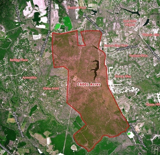
15400 Branders Bridge Rd
Richmond, VA
Branders Br & Bradley Br Par A
784-64-16-81-000-000
SWIFT CRK PT FRUIT HL
Agriculturalland
Chesterfield
A
Virginia
51041C0329E
1,032.64 AC
2025
Outlying Chesterfield
2025
Richmond VA
100705
DEMOGRAPHICS near 15400 Branders Bridge Rd
1 Mile
3 Mile
5 Mile
2024 Total Population
2,045
26,638
70,554
2029 Population
2,234
29,219
76,772
Pop Growth 2024-2029
+ 9.24%
+ 9.69%
+ 8.81%
Average Age
42
41
41
2024 Total Households
703
10,179
27,048
HH Growth 2024-2029
+ 9.25%
+ 9.86%
+ 8.90%
Median Household Inc
$96,396
$83,771
$77,643
Avg Household Size
2.80
2.60
2.60
2024 Avg HH Vehicles
3.00
2.00
2.00
Median Home Value
$341,449
$311,503
$279,902
Median Year Built
2002
1995
1989
Nearby Places
Map Layers
Map Styles
 Street
 Aerial
- Restaurants
- Banks
- Shops
- Fitness
- Groceries
PUBLIC TRANSPORTATION
COMMUTER RAIL
Petersburg Amtrak Station (Carolinian - Amtrak, Northeast Regional - Amtrak, Palmetto - Amtrak, Silver Meteor - Amtrak, Silver Star - Amtrak)
DRIVE
WALK
Distance
Petersburg Amtrak Station (Carolinian - Amtrak, Northeast Regional - Amtrak, Palmetto - Amtrak, Silver Meteor - Amtrak, Silver Star - Amtrak)
17 min
7.7 mi
AIRPORT
Richmond International
DRIVE
WALK
Distance
Richmond International
37 min
21.7 mi
Freight Ports
Virginia Port Authority - Richmond
DRIVE
WALK
Distance
Virginia Port Authority - Richmond
25 min
14.1 mi
Nearby Properties
Address
Land Use
TOTAL SIZE
Lot Size
Zoning
Address
Land Use
TOTAL SIZE
Lot Size
Zoning
21.01 AC
RMF - RES,
Address
Land Use
TOTAL SIZE
Lot Size
Zoning
121,974 SF
33.25 AC
RMF - RES,
Address
Land Use
TOTAL SIZE
Lot Size
Zoning
1.60 AC
RMF - RES,
Address
Land Use
TOTAL SIZE
Lot Size
Zoning
100 SF
21.30 AC
R7 - SINGL
Address
Land Use
TOTAL SIZE
Lot Size
Zoning
116,527 SF
25.57 AC
RMF - RES,
Address
Land Use
TOTAL SIZE
Lot Size
Zoning
157,534 SF
39.59 AC
R7 - SINGL
Address
Land Use
TOTAL SIZE
Lot Size
Zoning
100 SF
25.80 AC
R7 - SINGL
Address
Land Use
TOTAL SIZE
Lot Size
Zoning
752 SF
28.91 AC
R7 - SINGL
Address
Land Use
TOTAL SIZE
Lot Size
Zoning
70,882 SF
20.08 AC
C3 - COMMU
Address
Land Use
TOTAL SIZE
Lot Size
Zoning
69,048 SF
16 AC
R7 - SINGL
Address
Land Use
TOTAL SIZE
Lot Size
Zoning
29,808 SF
5.63 AC
C3 - COMMU
Address
Land Use
TOTAL SIZE
Lot Size
Zoning
78,429 SF
23.53 AC
RMF - RES,
Address
Land Use
TOTAL SIZE
Lot Size
Zoning
15,600 SF
3.97 AC
C3 - COMMU
Address
Land Use
TOTAL SIZE
Lot Size
Zoning
147,276 SF
27.04 AC
R7 - SINGL
Address
Land Use
TOTAL SIZE
Lot Size
Zoning
12.69 AC
R7 - SINGL
Address
Land Use
TOTAL SIZE
Lot Size
Zoning
193,838 SF
12.66 AC
C3 - COMMU
Address
Land Use
TOTAL SIZE
Lot Size
Zoning
12,210 SF
4.46 AC
RMF - RES,
Address
Land Use
TOTAL SIZE
Lot Size
Zoning
37,266 SF
9.40 AC
R7 - SINGL
Address
Land Use
TOTAL SIZE
Lot Size
Zoning
73,969 SF
27.42 AC
A - AGRICU
Address
Land Use
TOTAL SIZE
Lot Size
Zoning
82,503 SF
12.70 AC
A - AGRICU
Address
Land Use
TOTAL SIZE
Lot Size
Zoning
40,000 SF
9.32 AC
R7 - SINGL
Address
Land Use
TOTAL SIZE
Lot Size
Zoning
42,191 SF
4.76 AC
C3 - COMMU
Address
Land Use
TOTAL SIZE
Lot Size
Zoning
69,578 SF
36.60 AC
A - AGRICU
Address
Land Use
TOTAL SIZE
Lot Size
Zoning
24,297 SF
5.66 AC
C2 - NBHD
Address
Land Use
TOTAL SIZE
Lot Size
Zoning
38,519 SF
1.19 AC
R7 - SINGL
Address
Land Use
TOTAL SIZE
Lot Size
Zoning
85,110 SF
16.05 AC
A - AGRICU
Address
Land Use
TOTAL SIZE
Lot Size
Zoning
35,950 SF
6.63 AC
C3 - COMMU
Address
Land Use
TOTAL SIZE
Lot Size
Zoning
36,169 SF
5.09 AC
C2 - NBHD
Address
Land Use
TOTAL SIZE
Lot Size
Zoning
30,639 SF
3.65 AC
C5 - GEN B
Address
Land Use
TOTAL SIZE
Lot Size
Zoning
26,355 SF
3.96 AC
C3 - COMMU
The World's #1 Commercial Real Estate Marketplace
Connect with us
© 2025 CoStar Group
The information above has been obtained from sources believed reliable. While we do not doubt its accuracy we have not verified it and make no guarantee, warranty or representation about it. It is your responsibility to independently confirm its accuracy and completeness. Any projections, opinions, assumptions, or estimates used are for example only and do not represent the current or future performance of the property. The value of this transaction to you depends on tax and other factors which should be evaluated by your tax, financial, and legal advisors. You and your advisors should conduct a careful, independent investigation of the property to determine to your satisfaction the suitability of the property for your needs.