Property Record
15400 Sumpter Rd, Van Buren Township, MI 48111

NEARBY LISTINGS FOR SALE OR LEASE
Property Detail
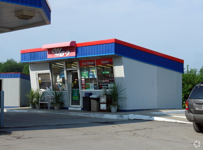
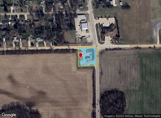
15400 Sumpter Rd
83-129-99-0002-002
33B2 THE N 210.01FT OF THE E 210FT OF THE E 1/2 OF THE NE 1/4 SEC 33 T3SR8E 1.01 AC
Conveniencestore
Wayne
X
Michigan
26163C0353E
0002
2025
0.52 AC
2025
Airport District
588300
Detroit
2,000 SF
Detroit-Warren-Dearborn, MI
DEMOGRAPHICS near 15400 Sumpter Rd
1 Mile
3 Mile
5 Mile
2024 Total Population
2,926
23,074
55,446
2029 Population
2,806
22,179
53,900
Pop Growth 2024-2029
(4.10%)
(3.88%)
(2.79%)
Average Age
42
42
41
2024 Total Households
1,208
10,384
23,249
HH Growth 2024-2029
(4.06%)
(3.87%)
(2.87%)
Median Household Inc
$50,602
$66,366
$69,695
Avg Household Size
2.40
2.20
2.30
2024 Avg HH Vehicles
2.00
2.00
2.00
Median Home Value
$186,613
$237,730
$221,564
Median Year Built
1989
1977
1979
Nearby Places
Map Layers
Map Styles
 Street
 Aerial
- Restaurants
- Banks
- Shops
- Fitness
- Groceries
PUBLIC TRANSPORTATION
AIRPORT
Detroit Metro Wayne County
DRIVE
WALK
Distance
Detroit Metro Wayne County
19 min
10.4 mi
Windsor International
DRIVE
WALK
Distance
Windsor International
60 min
39.1 mi
Freight Ports
Port of Toledo
DRIVE
WALK
Distance
Port of Toledo
69 min
53.4 mi
Nearby Properties
Address
Land Use
TOTAL SIZE
Lot Size
Zoning
Address
Land Use
TOTAL SIZE
Lot Size
Zoning
461,566 SF
50.13 AC
RM MULT
Address
Land Use
TOTAL SIZE
Lot Size
Zoning
357,286 SF
36.79 AC
RM MULT
Address
Land Use
TOTAL SIZE
Lot Size
Zoning
432.42 AC
M2 GEN
Address
Land Use
TOTAL SIZE
Lot Size
Zoning
198,549 SF
13.43 AC
RM MULT
Address
Land Use
TOTAL SIZE
Lot Size
Zoning
630,828 SF
62.51 AC
R1B
Address
Land Use
TOTAL SIZE
Lot Size
Zoning
196,044 SF
18.67 AC
RM MULT
Address
Land Use
TOTAL SIZE
Lot Size
Zoning
132,528 SF
5.91 AC
C2 EXT
Address
Land Use
TOTAL SIZE
Lot Size
Zoning
199,776 SF
39.34 AC
C2 EXT
Address
Land Use
TOTAL SIZE
Lot Size
Zoning
191,446 SF
22.76 AC
C2 EXT
Address
Land Use
TOTAL SIZE
Lot Size
Zoning
198,304 SF
23.96 AC
C2 EXT
Address
Land Use
TOTAL SIZE
Lot Size
Zoning
3,184 SF
41.02 AC
Address
Land Use
TOTAL SIZE
Lot Size
Zoning
119,319 SF
10.23 AC
RM MULT
Address
Land Use
TOTAL SIZE
Lot Size
Zoning
69,415 SF
11.32 AC
C2 EXT
Address
Land Use
TOTAL SIZE
Lot Size
Zoning
140,677 SF
11.19 AC
RM MULT
Address
Land Use
TOTAL SIZE
Lot Size
Zoning
158,744 SF
10.17 AC
RM MULT
Address
Land Use
TOTAL SIZE
Lot Size
Zoning
500 SF
37.70 AC
Address
Land Use
TOTAL SIZE
Lot Size
Zoning
86,611 SF
15.38 AC
C2 EXT
Address
Land Use
TOTAL SIZE
Lot Size
Zoning
62,729 SF
20.01 AC
C2 EXT
Address
Land Use
TOTAL SIZE
Lot Size
Zoning
72,834 SF
4.97 AC
RM MULT
Address
Land Use
TOTAL SIZE
Lot Size
Zoning
73,239 SF
6.18 AC
RM MULT
Address
Land Use
TOTAL SIZE
Lot Size
Zoning
96,458 SF
7.80 AC
RM MULT
Address
Land Use
TOTAL SIZE
Lot Size
Zoning
95,230 SF
6.32 AC
RM MULT
Address
Land Use
TOTAL SIZE
Lot Size
Zoning
107,235 SF
7.37 AC
Address
Land Use
TOTAL SIZE
Lot Size
Zoning
66,340 SF
6.59 AC
RM MULT
Address
Land Use
TOTAL SIZE
Lot Size
Zoning
54.32 AC
RMH MOB
Address
Land Use
TOTAL SIZE
Lot Size
Zoning
45,934 SF
35.95 AC
M2 GEN
Address
Land Use
TOTAL SIZE
Lot Size
Zoning
57,174 SF
4.50 AC
Address
Land Use
TOTAL SIZE
Lot Size
Zoning
36,200 SF
15.23 AC
Address
Land Use
TOTAL SIZE
Lot Size
Zoning
4,442 SF
42.38 AC
RMH MOB
Address
Land Use
TOTAL SIZE
Lot Size
Zoning
43,948 SF
4.71 AC
C2 EXT
The World's #1 Commercial Real Estate Marketplace
Connect with us
© 2026 CoStar Group
The information above has been obtained from sources believed reliable. While we do not doubt its accuracy we have not verified it and make no guarantee, warranty or representation about it. It is your responsibility to independently confirm its accuracy and completeness. Any projections, opinions, assumptions, or estimates used are for example only and do not represent the current or future performance of the property. The value of this transaction to you depends on tax and other factors which should be evaluated by your tax, financial, and legal advisors. You and your advisors should conduct a careful, independent investigation of the property to determine to your satisfaction the suitability of the property for your needs.