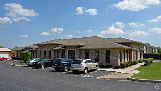
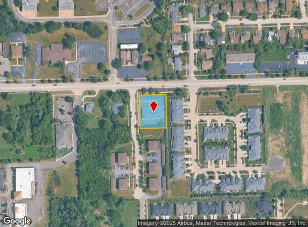
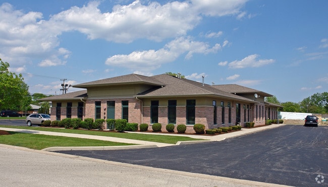
Property Record
15400 E 127Th St, Lemont, IL 60439

NEARBY LISTINGS FOR SALE OR LEASE
Property Detail
15400 E 127Th St
22-32-200-045-0000
Stonehenge Of Lemont
Commercialbuilding
Cook
X
Illinois
17197C0090G
0.66 AC
2023
Joliet/Central Will
2024
Chicago
824003
Chicago-Naperville-Elgin, IL-IN-WI
7,470 SF
DEMOGRAPHICS near 15400 E 127Th St
1 Mile
3 Mile
5 Mile
2024 Total Population
8,809
28,725
92,895
2029 Population
8,528
28,061
91,634
Pop Growth 2024-2029
(3.19%)
(2.31%)
(1.36%)
Average Age
43
43
41
2024 Total Households
3,191
10,438
32,806
HH Growth 2024-2029
(3.54%)
(2.52%)
(1.42%)
Median Household Inc
$121,838
$113,927
$96,388
Avg Household Size
2.70
2.70
2.80
2024 Avg HH Vehicles
2.00
2.00
2.00
Median Home Value
$390,121
$393,963
$333,660
Median Year Built
1990
1989
1985
Nearby Places
Map Layers
Map Styles
 Street
 Aerial
- Restaurants
- Banks
- Shops
- Fitness
- Groceries
PUBLIC TRANSPORTATION
COMMUTER RAIL
Lemont Station (Heritage Corridor Line - Northeast Illinois Regional Commuter Railroad (Metra))
DRIVE
WALK
Distance
Lemont Station (Heritage Corridor Line - Northeast Illinois Regional Commuter Railroad (Metra))
3 min
1.6 mi
DRIVE
WALK
Distance
9 min
4.3 mi
AIRPORT
Chicago Midway International
DRIVE
WALK
Distance
Chicago Midway International
29 min
19.5 mi
Chicago O'Hare International
DRIVE
WALK
Distance
Chicago O'Hare International
46 min
30.9 mi
Nearby Properties
Address
Land Use
TOTAL SIZE
Lot Size
Zoning
Address
Land Use
TOTAL SIZE
Lot Size
Zoning
32.82 AC
Address
Land Use
TOTAL SIZE
Lot Size
Zoning
52.19 AC
Address
Land Use
TOTAL SIZE
Lot Size
Zoning
49.91 AC
Address
Land Use
TOTAL SIZE
Lot Size
Zoning
24.65 AC
Address
Land Use
TOTAL SIZE
Lot Size
Zoning
264,310 SF
12.21 AC
I
Address
Land Use
TOTAL SIZE
Lot Size
Zoning
18.82 AC
Address
Land Use
TOTAL SIZE
Lot Size
Zoning
165.89 AC
Address
Land Use
TOTAL SIZE
Lot Size
Zoning
30.56 AC
Address
Land Use
TOTAL SIZE
Lot Size
Zoning
19.21 AC
Address
Land Use
TOTAL SIZE
Lot Size
Zoning
17.18 AC
Address
Land Use
TOTAL SIZE
Lot Size
Zoning
25.79 AC
Address
Land Use
TOTAL SIZE
Lot Size
Zoning
18.96 AC
Address
Land Use
TOTAL SIZE
Lot Size
Zoning
263,010 SF
13.56 AC
I
Address
Land Use
TOTAL SIZE
Lot Size
Zoning
17.18 AC
Address
Land Use
TOTAL SIZE
Lot Size
Zoning
19.01 AC
Address
Land Use
TOTAL SIZE
Lot Size
Zoning
8,577 SF
160 AC
Address
Land Use
TOTAL SIZE
Lot Size
Zoning
121.17 AC
Address
Land Use
TOTAL SIZE
Lot Size
Zoning
119,270 SF
7 AC
I
Address
Land Use
TOTAL SIZE
Lot Size
Zoning
24.85 AC
Address
Land Use
TOTAL SIZE
Lot Size
Zoning
253,622 SF
13.09 AC
Address
Land Use
TOTAL SIZE
Lot Size
Zoning
153,050 SF
8.95 AC
Address
Land Use
TOTAL SIZE
Lot Size
Zoning
165,524 SF
9.36 AC
I
Address
Land Use
TOTAL SIZE
Lot Size
Zoning
180,022 SF
9.49 AC
Address
Land Use
TOTAL SIZE
Lot Size
Zoning
14,972 SF
2.91 AC
C
Address
Land Use
TOTAL SIZE
Lot Size
Zoning
308,882 SF
13.68 AC
I
Address
Land Use
TOTAL SIZE
Lot Size
Zoning
26.19 AC
Address
Land Use
TOTAL SIZE
Lot Size
Zoning
197,558 SF
15.36 AC
I
Address
Land Use
TOTAL SIZE
Lot Size
Zoning
Address
Land Use
TOTAL SIZE
Lot Size
Zoning
97,816 SF
10.04 AC
I
Address
Land Use
TOTAL SIZE
Lot Size
Zoning
9.59 AC
The World's #1 Commercial Real Estate Marketplace
Connect with us
© 2025 CoStar Group
The information above has been obtained from sources believed reliable. While we do not doubt its accuracy we have not verified it and make no guarantee, warranty or representation about it. It is your responsibility to independently confirm its accuracy and completeness. Any projections, opinions, assumptions, or estimates used are for example only and do not represent the current or future performance of the property. The value of this transaction to you depends on tax and other factors which should be evaluated by your tax, financial, and legal advisors. You and your advisors should conduct a careful, independent investigation of the property to determine to your satisfaction the suitability of the property for your needs.