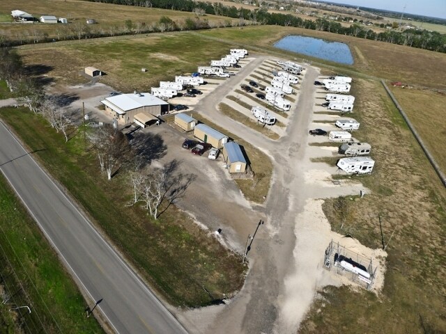
Property Record
15402 E Highway 35, Danbury, TX 77534


NEARBY LISTINGS FOR SALE OR LEASE
-
-
View all Danbury listings for sale on LoopNet.com
Property Detail
15402 E Highway 35
0014-0005-208
Henry Austin
Commercialnec
A0014 HENRY AUSTIN TRACT 8I4B-8B1A ACRES 5.0
AE
Brazoria
48039C0455K
Texas
2024
5 AC
2025
South Hwy 35
662200
Houston
5,000 SF
Houston-Pasadena-The Woodlands, TX
DEMOGRAPHICS near 15402 E Highway 35
1 mile
3 mile
5 mile
2024 Total Population
396
2,942
9,234
2029 Population
432
3,202
10,240
Pop Growth 2024-2029
+ 9.09%
+ 8.84%
+ 10.89%
Average Age
39
38
37
2024 Total Households
92
900
3,153
HH Growth 2024-2029
+ 9.78%
+ 9.11%
+ 11.32%
Median Household Inc
$82,500
$85,919
$71,368
Avg Household Size
2.80
2.90
2.70
2024 Avg HH Vehicles
2.00
3.00
2.00
Median Home Value
$274,999
$290,908
$235,934
Median Year Built
1982
1979
1984
Nearby Places
Map Layers
Map Styles
 Street
 Aerial
Transit
 Traffic
 Biking
Places
Listings with unknown addresses are not visible on the map
- Restaurants
- Banks
- Shops
- Fitness
- Groceries
PUBLIC TRANSPORTATION
AIRPORT
William P Hobby
Drive
Walk
Distance
William P Hobby
53 min
31.7 mi
Freight Ports
Port Freeport
Drive
Walk
Distance
Port Freeport
36 min
23.8 mi
SALE & LEASE HISTORY
LISTING DATE
SALE/LEASE

Sep 24, 2016
For Sale
Nearby Properties
Address
Land Use
TOTAL SIZE
Lot Size
Zoning
Address
Land Use
TOTAL SIZE
Lot Size
Zoning
41,293 SF
195 AC
0009
Address
Land Use
TOTAL SIZE
Lot Size
Zoning
53,347 SF
11.70 AC
0125
Address
Land Use
TOTAL SIZE
Lot Size
Zoning
17,688 SF
4.66 AC
0280
Address
Land Use
TOTAL SIZE
Lot Size
Zoning
54,730 SF
5 AC
Address
Land Use
TOTAL SIZE
Lot Size
Zoning
33,991 SF
3 AC
0126
Address
Land Use
TOTAL SIZE
Lot Size
Zoning
21,320 SF
2.07 AC
Address
Land Use
TOTAL SIZE
Lot Size
Zoning
37,354 SF
3 AC
0052
Address
Land Use
TOTAL SIZE
Lot Size
Zoning
12.48 AC
Address
Land Use
TOTAL SIZE
Lot Size
Zoning
5,500 SF
1.96 AC
0001
Address
Land Use
TOTAL SIZE
Lot Size
Zoning
15,796 SF
14.26 AC
Address
Land Use
TOTAL SIZE
Lot Size
Zoning
5,012 SF
317.90 AC
0002
Address
Land Use
TOTAL SIZE
Lot Size
Zoning
6,500 SF
200.13 AC
Address
Land Use
TOTAL SIZE
Lot Size
Zoning
15,046 SF
3 AC
Address
Land Use
TOTAL SIZE
Lot Size
Zoning
9,100 SF
1.09 AC
0272
Address
Land Use
TOTAL SIZE
Lot Size
Zoning
Address
Land Use
TOTAL SIZE
Lot Size
Zoning
1,600 SF
14.43 AC
Address
Land Use
TOTAL SIZE
Lot Size
Zoning
6,000 SF
0.58 AC
Address
Land Use
TOTAL SIZE
Lot Size
Zoning
4,628 SF
11 AC
Address
Land Use
TOTAL SIZE
Lot Size
Zoning
22,045 SF
0.99 AC
0245
Address
Land Use
TOTAL SIZE
Lot Size
Zoning
3,288 SF
1.07 AC
Address
Land Use
TOTAL SIZE
Lot Size
Zoning
4,800 SF
8.56 AC
0003
Address
Land Use
TOTAL SIZE
Lot Size
Zoning
4,356 SF
17.19 AC
0086
Address
Land Use
TOTAL SIZE
Lot Size
Zoning
7,830 SF
1 AC
0286
Address
Land Use
TOTAL SIZE
Lot Size
Zoning
8,043 SF
100 AC
Address
Land Use
TOTAL SIZE
Lot Size
Zoning
3,200 SF
116.60 AC
0010
Address
Land Use
TOTAL SIZE
Lot Size
Zoning
6,603 SF
3.40 AC
Address
Land Use
TOTAL SIZE
Lot Size
Zoning
12,014 SF
24.11 AC
Address
Land Use
TOTAL SIZE
Lot Size
Zoning
6,401 SF
12.10 AC
Address
Land Use
TOTAL SIZE
Lot Size
Zoning
6,642 SF
7 AC
0007
Address
Land Use
TOTAL SIZE
Lot Size
Zoning
7,159 SF
10 AC
The World's #1 Commercial Real Estate Marketplace
Connect with us
© 2026 CoStar Group
The information above has been obtained from sources believed reliable. While we do not doubt its accuracy we have not verified it and make no guarantee, warranty or representation about it. It is your responsibility to independently confirm its accuracy and completeness. Any projections, opinions, assumptions, or estimates used are for example only and do not represent the current or future performance of the property. The value of this transaction to you depends on tax and other factors which should be evaluated by your tax, financial, and legal advisors. You and your advisors should conduct a careful, independent investigation of the property to determine to your satisfaction the suitability of the property for your needs.