Property Record
1541 Mount Tabor Rd, Maryville, TN 37801


NEARBY LISTINGS FOR SALE OR LEASE
Property Detail
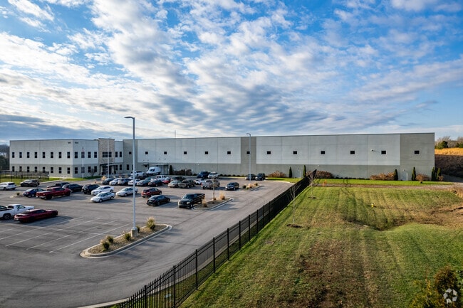
1541 Mount Tabor Rd
045 17205 000
Industrial Development Board
Warehouse
Blount
A
Tennessee
47009C0119C
4
0
20.32 AC
2025
Blount County
011201
Knoxville
183,772 SF
Knoxville, TN
DEMOGRAPHICS near 1541 Mount Tabor Rd
1 Mile
3 Mile
5 Mile
2024 Total Population
2,612
30,920
74,414
2029 Population
2,837
33,748
80,878
Pop Growth 2024-2029
+ 8.61%
+ 9.15%
+ 8.69%
Average Age
40
40
41
2024 Total Households
1,084
12,700
29,869
HH Growth 2024-2029
+ 8.58%
+ 9.19%
+ 8.75%
Median Household Inc
$42,230
$57,541
$62,065
Avg Household Size
2.40
2.30
2.40
2024 Avg HH Vehicles
2.00
2.00
2.00
Median Home Value
$232,894
$233,471
$235,171
Median Year Built
1995
1988
1984
Nearby Places
Map Layers
Map Styles
 Street
 Aerial
- Restaurants
- Banks
- Shops
- Fitness
- Groceries
PUBLIC TRANSPORTATION
AIRPORT
McGhee Tyson
DRIVE
WALK
Distance
McGhee Tyson
17 min
7.7 mi
Nearby Properties
Address
Land Use
TOTAL SIZE
Lot Size
Zoning
Address
Land Use
TOTAL SIZE
Lot Size
Zoning
635,728 SF
234.13 AC
I
Address
Land Use
TOTAL SIZE
Lot Size
Zoning
326,318 SF
IND
Address
Land Use
TOTAL SIZE
Lot Size
Zoning
75,124 SF
9.11 AC
E
Address
Land Use
TOTAL SIZE
Lot Size
Zoning
144,298 SF
4.49 AC
G
Address
Land Use
TOTAL SIZE
Lot Size
Zoning
516,444 SF
83.49 AC
IND
Address
Land Use
TOTAL SIZE
Lot Size
Zoning
150,532 SF
5.39 AC
G
Address
Land Use
TOTAL SIZE
Lot Size
Zoning
194,268 SF
33.99 AC
IND
Address
Land Use
TOTAL SIZE
Lot Size
Zoning
10,061 SF
22.74 AC
SPLIT
Address
Land Use
TOTAL SIZE
Lot Size
Zoning
101,640 SF
7.41 AC
SPLIT
Address
Land Use
TOTAL SIZE
Lot Size
Zoning
88,869 SF
6.83 AC
CBDS
Address
Land Use
TOTAL SIZE
Lot Size
Zoning
78,099 SF
20 AC
S
Address
Land Use
TOTAL SIZE
Lot Size
Zoning
26,024 SF
16.24 AC
C
Address
Land Use
TOTAL SIZE
Lot Size
Zoning
64,033 SF
5.65 AC
O-3
Address
Land Use
TOTAL SIZE
Lot Size
Zoning
279,826 SF
50.95 AC
IND
Address
Land Use
TOTAL SIZE
Lot Size
Zoning
23,916 SF
9.94 AC
E1
Address
Land Use
TOTAL SIZE
Lot Size
Zoning
33,912 SF
19.91 AC
HDR
Address
Land Use
TOTAL SIZE
Lot Size
Zoning
74,071 SF
5.19 AC
HIC
Address
Land Use
TOTAL SIZE
Lot Size
Zoning
158,466 SF
14.78 AC
E1
Address
Land Use
TOTAL SIZE
Lot Size
Zoning
41,938 SF
7.42 AC
BT
Address
Land Use
TOTAL SIZE
Lot Size
Zoning
122,648 SF
0.10 AC
CBD
Address
Land Use
TOTAL SIZE
Lot Size
Zoning
323,040 SF
87.30 AC
IND
Address
Land Use
TOTAL SIZE
Lot Size
Zoning
55,708 SF
6.95 AC
BT
Address
Land Use
TOTAL SIZE
Lot Size
Zoning
153,883 SF
IND
Address
Land Use
TOTAL SIZE
Lot Size
Zoning
15,340 SF
5 AC
F
Address
Land Use
TOTAL SIZE
Lot Size
Zoning
104,327 SF
26.19 AC
CC
Address
Land Use
TOTAL SIZE
Lot Size
Zoning
156,895 SF
45.10 AC
IND
Address
Land Use
TOTAL SIZE
Lot Size
Zoning
106,466 SF
2.65 AC
CC
Address
Land Use
TOTAL SIZE
Lot Size
Zoning
533,928 SF
97.90 AC
IND
Address
Land Use
TOTAL SIZE
Lot Size
Zoning
172.05 AC
G
Address
Land Use
TOTAL SIZE
Lot Size
Zoning
86.20 AC
F
The World's #1 Commercial Real Estate Marketplace
Connect with us
© 2026 CoStar Group
The information above has been obtained from sources believed reliable. While we do not doubt its accuracy we have not verified it and make no guarantee, warranty or representation about it. It is your responsibility to independently confirm its accuracy and completeness. Any projections, opinions, assumptions, or estimates used are for example only and do not represent the current or future performance of the property. The value of this transaction to you depends on tax and other factors which should be evaluated by your tax, financial, and legal advisors. You and your advisors should conduct a careful, independent investigation of the property to determine to your satisfaction the suitability of the property for your needs.