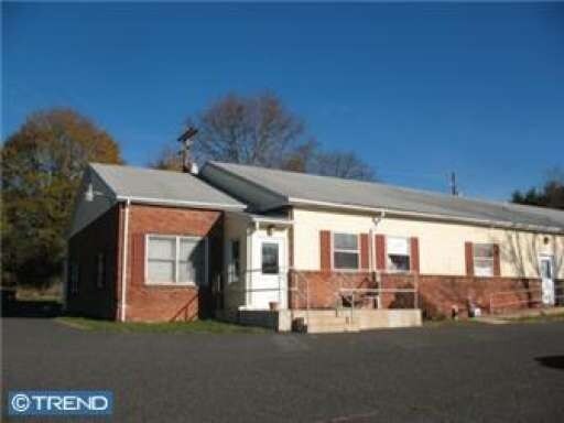
Property Record
1541 N Route 309 Blvd, Sellersville, PA 18960
NEARBY LISTINGS FOR SALE OR LEASE
Property Detail
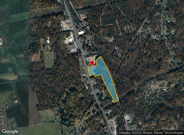
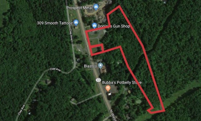
1541 N Route 309 Blvd
42-004-123-003
16.19A E S US309 290 N T 475
Officebuilding
Bucks
A
Pennsylvania
42017C0110J
16.19 AC
2024
Upper Bucks County
2025
Philadelphia
102500
Philadelphia-Camden-Wilmington, PA-NJ-DE-MD
7,945 SF
DEMOGRAPHICS near 1541 N Route 309 Blvd
1 Mile
3 Mile
5 Mile
2024 Total Population
898
15,311
53,005
2029 Population
893
15,345
52,993
Pop Growth 2024-2029
(0.56%)
+ 0.22%
(0.02%)
Average Age
48
43
42
2024 Total Households
340
5,708
19,406
HH Growth 2024-2029
(0.59%)
+ 0.02%
(0.15%)
Median Household Inc
$93,636
$95,909
$98,528
Avg Household Size
2.40
2.60
2.60
2024 Avg HH Vehicles
2.00
2.00
2.00
Median Home Value
$431,818
$336,943
$336,776
Median Year Built
1967
1977
1978
Nearby Places
Map Layers
Map Styles
 Street
 Aerial
- Restaurants
- Banks
- Shops
- Fitness
- Groceries
PUBLIC TRANSPORTATION
AIRPORT
Lehigh Valley International
DRIVE
WALK
Distance
Lehigh Valley International
27 min
15.6 mi
Freight Ports
Port of Philadelphia
DRIVE
WALK
Distance
Port of Philadelphia
67 min
41.9 mi
SALE & LEASE HISTORY
LISTING DATE
SALE/LEASE

Sep 25, 2016
For Lease
Sep 05, 2018
For Sale
Feb 22, 2019
For Lease
Dec 10, 2018
For Sale
Nearby Properties
Address
Land Use
TOTAL SIZE
Lot Size
Zoning
Address
Land Use
TOTAL SIZE
Lot Size
Zoning
42,320 SF
7.03 AC
I
Address
Land Use
TOTAL SIZE
Lot Size
Zoning
58,156 SF
13.66 AC
R1
Address
Land Use
TOTAL SIZE
Lot Size
Zoning
94,903 SF
8.69 AC
C3
Address
Land Use
TOTAL SIZE
Lot Size
Zoning
52,804 SF
2.51 AC
I
Address
Land Use
TOTAL SIZE
Lot Size
Zoning
276,132 SF
61.72 AC
PC
Address
Land Use
TOTAL SIZE
Lot Size
Zoning
51,884 SF
40.42 AC
EXT
Address
Land Use
TOTAL SIZE
Lot Size
Zoning
5,525 SF
2.78 AC
C
Address
Land Use
TOTAL SIZE
Lot Size
Zoning
13,306 SF
2.23 AC
R2
Address
Land Use
TOTAL SIZE
Lot Size
Zoning
98,230 SF
14.07 AC
Address
Land Use
TOTAL SIZE
Lot Size
Zoning
336 SF
31.85 AC
R-2
Address
Land Use
TOTAL SIZE
Lot Size
Zoning
22,120 SF
10 AC
R-2
Address
Land Use
TOTAL SIZE
Lot Size
Zoning
13,157 SF
5.27 AC
R-2
Address
Land Use
TOTAL SIZE
Lot Size
Zoning
54,488 SF
2.77 AC
R-3
Address
Land Use
TOTAL SIZE
Lot Size
Zoning
145,197 SF
17.11 AC
PC
Address
Land Use
TOTAL SIZE
Lot Size
Zoning
12,761 SF
16.24 AC
C
Address
Land Use
TOTAL SIZE
Lot Size
Zoning
31,140 SF
2.95 AC
LI-1
Address
Land Use
TOTAL SIZE
Lot Size
Zoning
20,304 SF
2.50 AC
R-1
Address
Land Use
TOTAL SIZE
Lot Size
Zoning
46,600 SF
4.43 AC
I
Address
Land Use
TOTAL SIZE
Lot Size
Zoning
4,034 SF
2.32 AC
C
Address
Land Use
TOTAL SIZE
Lot Size
Zoning
22,936 SF
3.43 AC
R2
Address
Land Use
TOTAL SIZE
Lot Size
Zoning
33,180 SF
2.40 AC
R2
Address
Land Use
TOTAL SIZE
Lot Size
Zoning
19,730 SF
3 AC
C1
Address
Land Use
TOTAL SIZE
Lot Size
Zoning
15,158 SF
0.27 AC
C1
Address
Land Use
TOTAL SIZE
Lot Size
Zoning
1,884 SF
53.18 AC
C
Address
Land Use
TOTAL SIZE
Lot Size
Zoning
2,480 SF
0.75 AC
C1
Address
Land Use
TOTAL SIZE
Lot Size
Zoning
127,968 SF
15.38 AC
PC
Address
Land Use
TOTAL SIZE
Lot Size
Zoning
12,761 SF
Address
Land Use
TOTAL SIZE
Lot Size
Zoning
2,368 SF
16.69 AC
R1
Address
Land Use
TOTAL SIZE
Lot Size
Zoning
3,307 SF
0.73 AC
C1
Address
Land Use
TOTAL SIZE
Lot Size
Zoning
8,864 SF
6.33 AC
R-2
The World's #1 Commercial Real Estate Marketplace
Connect with us
© 2025 CoStar Group
The information above has been obtained from sources believed reliable. While we do not doubt its accuracy we have not verified it and make no guarantee, warranty or representation about it. It is your responsibility to independently confirm its accuracy and completeness. Any projections, opinions, assumptions, or estimates used are for example only and do not represent the current or future performance of the property. The value of this transaction to you depends on tax and other factors which should be evaluated by your tax, financial, and legal advisors. You and your advisors should conduct a careful, independent investigation of the property to determine to your satisfaction the suitability of the property for your needs.