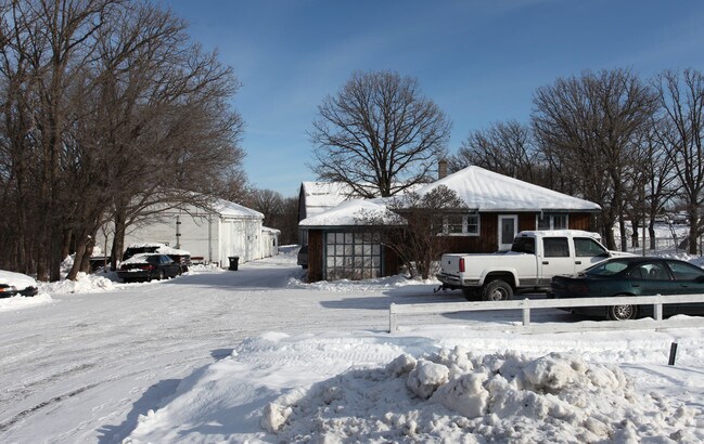
Property Record
15415 Saint Francis Blvd, Anoka, MN 55303

NEARBY LISTINGS FOR SALE OR LEASE
-
-
View all Anoka listings for sale on LoopNet.com
Property Detail
15415 Saint Francis Blvd
Minneapolis/St Paul
Becker Addition
Minneapolis-St. Paul-Bloomington, MN-WI
Anoka
24-32-25-23-0120
Minnesota
Sfr
17.82 AC
1,152 SF
Anoka County Outlying
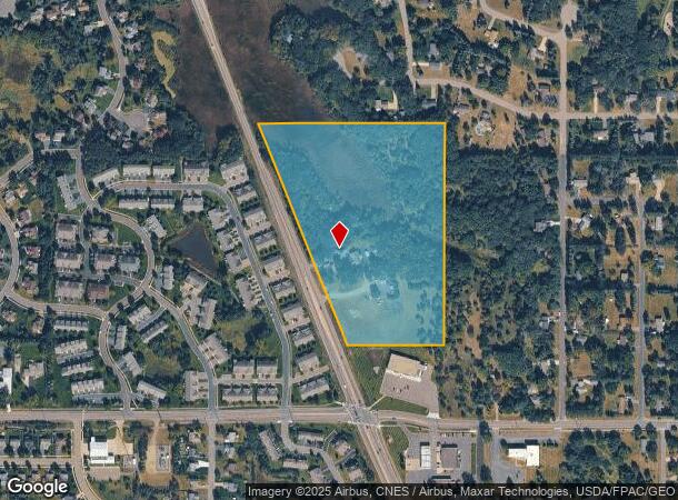
DEMOGRAPHICS near 15415 Saint Francis Blvd
1 Mile
3 Mile
5 Mile
2024 Total Population
6,441
33,395
86,214
2029 Population
6,636
34,694
89,306
Pop Growth 2024-2029
+ 3.03%
+ 3.89%
+ 3.59%
Average Age
39
39
40
2024 Total Households
2,197
11,872
31,986
HH Growth 2024-2029
+ 3.05%
+ 3.96%
+ 3.65%
Median Household Inc
$118,710
$100,890
$95,508
Avg Household Size
2.90
2.80
2.60
2024 Avg HH Vehicles
2.00
2.00
2.00
Median Home Value
$338,222
$320,631
$321,324
Median Year Built
1998
1992
1989
Nearby Places
Map Layers
Map Styles
 Street
 Aerial
- Restaurants
- Banks
- Shops
- Fitness
- Groceries
PUBLIC TRANSPORTATION
COMMUTER RAIL
DRIVE
WALK
Distance
10 min
4.0 mi
Anoka Station (Northstar Corridor - Northstar Commuter Rail)
DRIVE
WALK
Distance
Anoka Station (Northstar Corridor - Northstar Commuter Rail)
9 min
4.1 mi
AIRPORT
Minneapolis-St Paul International/Wold-Chamberlain
DRIVE
WALK
Distance
Minneapolis-St Paul International/Wold-Chamberlain
57 min
36.7 mi
Nearby Properties
Address
Land Use
TOTAL SIZE
Lot Size
Zoning
Address
Land Use
TOTAL SIZE
Lot Size
Zoning
2,400 SF
72.45 AC
Address
Land Use
TOTAL SIZE
Lot Size
Zoning
363,449 SF
82.99 AC
R-1
Address
Land Use
TOTAL SIZE
Lot Size
Zoning
68,362 SF
Address
Land Use
TOTAL SIZE
Lot Size
Zoning
225,748 SF
Address
Land Use
TOTAL SIZE
Lot Size
Zoning
382,508 SF
Address
Land Use
TOTAL SIZE
Lot Size
Zoning
2,011 SF
34 AC
Address
Land Use
TOTAL SIZE
Lot Size
Zoning
343,297 SF
25.42 AC
M-1
Address
Land Use
TOTAL SIZE
Lot Size
Zoning
153,964 SF
3.90 AC
Address
Land Use
TOTAL SIZE
Lot Size
Zoning
140,288 SF
5.12 AC
Address
Land Use
TOTAL SIZE
Lot Size
Zoning
300,547 SF
19.21 AC
Address
Land Use
TOTAL SIZE
Lot Size
Zoning
298,148 SF
17.70 AC
M-1
Address
Land Use
TOTAL SIZE
Lot Size
Zoning
319,019 SF
17.14 AC
Address
Land Use
TOTAL SIZE
Lot Size
Zoning
114,281 SF
3.19 AC
PRD-4
Address
Land Use
TOTAL SIZE
Lot Size
Zoning
319,664 SF
19.62 AC
M-1
Address
Land Use
TOTAL SIZE
Lot Size
Zoning
436,117 SF
17.75 AC
M-1
Address
Land Use
TOTAL SIZE
Lot Size
Zoning
190,285 SF
12.98 AC
Address
Land Use
TOTAL SIZE
Lot Size
Zoning
Address
Land Use
TOTAL SIZE
Lot Size
Zoning
201,859 SF
9.21 AC
Address
Land Use
TOTAL SIZE
Lot Size
Zoning
100 SF
5.42 AC
R-2
Address
Land Use
TOTAL SIZE
Lot Size
Zoning
Address
Land Use
TOTAL SIZE
Lot Size
Zoning
83,357 SF
5.35 AC
Address
Land Use
TOTAL SIZE
Lot Size
Zoning
98,933 SF
9.61 AC
R-2
Address
Land Use
TOTAL SIZE
Lot Size
Zoning
172,332 SF
Address
Land Use
TOTAL SIZE
Lot Size
Zoning
75,262 SF
6.54 AC
Address
Land Use
TOTAL SIZE
Lot Size
Zoning
84,201 SF
1.87 AC
Address
Land Use
TOTAL SIZE
Lot Size
Zoning
151,524 SF
18.10 AC
Address
Land Use
TOTAL SIZE
Lot Size
Zoning
102,938 SF
Address
Land Use
TOTAL SIZE
Lot Size
Zoning
166,230 SF
36.66 AC
Address
Land Use
TOTAL SIZE
Lot Size
Zoning
97,017 SF
2.50 AC
B-1
Address
Land Use
TOTAL SIZE
Lot Size
Zoning
108,542 SF
4.71 AC
M-1
The World's #1 Commercial Real Estate Marketplace
Connect with us
© 2025 CoStar Group
The information above has been obtained from sources believed reliable. While we do not doubt its accuracy we have not verified it and make no guarantee, warranty or representation about it. It is your responsibility to independently confirm its accuracy and completeness. Any projections, opinions, assumptions, or estimates used are for example only and do not represent the current or future performance of the property. The value of this transaction to you depends on tax and other factors which should be evaluated by your tax, financial, and legal advisors. You and your advisors should conduct a careful, independent investigation of the property to determine to your satisfaction the suitability of the property for your needs.