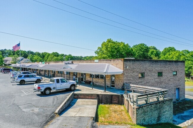
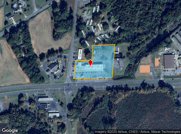
Property Record
1554 Nc 24 27 Byp W, Albemarle, NC 28001
NEARBY LISTINGS FOR SALE OR LEASE
-
-
View all Albemarle listings for lease on LoopNet.com
Property Detail
1554 Nc 24 27 Byp W
6537-01-49-2053
BLDG 1554 NC 24/27 BYPAS 653701003
Communitycenter
Stanly
X
North Carolina
3710653700J
2.73 AC
2025
Stanly County
2025
Charlotte
931202
Albemarle, NC
18,806 SF
DEMOGRAPHICS near 1554 Nc 24 27 Byp W
1 Mile
3 Mile
5 Mile
2024 Total Population
1,676
13,672
24,817
2029 Population
1,820
14,831
26,903
Pop Growth 2024-2029
+ 8.59%
+ 8.48%
+ 8.41%
Average Age
41
41
42
2024 Total Households
695
5,755
10,239
HH Growth 2024-2029
+ 8.35%
+ 8.41%
+ 8.36%
Median Household Inc
$56,311
$42,754
$48,946
Avg Household Size
2.40
2.30
2.30
2024 Avg HH Vehicles
2.00
2.00
2.00
Median Home Value
$170,180
$138,821
$159,620
Median Year Built
1968
1961
1968
Nearby Places
- Restaurants
- Banks
- Shops
- Fitness
- Groceries
SALE & LEASE HISTORY
LISTING DATE
SALE/LEASE

Dec 30, 2016
For Lease
Nearby Properties
Address
Land Use
TOTAL SIZE
Lot Size
Zoning
Address
Land Use
TOTAL SIZE
Lot Size
Zoning
232,921 SF
16.84 AC
MULTIPLE
Address
Land Use
TOTAL SIZE
Lot Size
Zoning
123,879 SF
24.13 AC
Address
Land Use
TOTAL SIZE
Lot Size
Zoning
70,906 SF
4.22 AC
CBD
Address
Land Use
TOTAL SIZE
Lot Size
Zoning
142,992 SF
13.23 AC
MULTIPLE
Address
Land Use
TOTAL SIZE
Lot Size
Zoning
187,271 SF
20.52 AC
GHBD
Address
Land Use
TOTAL SIZE
Lot Size
Zoning
39,000 SF
44.71 AC
MULTIPLE
Address
Land Use
TOTAL SIZE
Lot Size
Zoning
97,596 SF
6.07 AC
R-8A
Address
Land Use
TOTAL SIZE
Lot Size
Zoning
47,550 SF
2.89 AC
HMD
Address
Land Use
TOTAL SIZE
Lot Size
Zoning
37,670 SF
31.56 AC
Address
Land Use
TOTAL SIZE
Lot Size
Zoning
41,184 SF
0.99 AC
CBD
Address
Land Use
TOTAL SIZE
Lot Size
Zoning
282.74 AC
MULTIPLE
Address
Land Use
TOTAL SIZE
Lot Size
Zoning
30,831 SF
2.32 AC
CBD
Address
Land Use
TOTAL SIZE
Lot Size
Zoning
20,008 SF
3 AC
NBD
Address
Land Use
TOTAL SIZE
Lot Size
Zoning
57,086 SF
1.10 AC
RO
Address
Land Use
TOTAL SIZE
Lot Size
Zoning
56,294 SF
8.80 AC
RO
Address
Land Use
TOTAL SIZE
Lot Size
Zoning
34,624 SF
4.42 AC
Address
Land Use
TOTAL SIZE
Lot Size
Zoning
28,491 SF
4.94 AC
R-10
Address
Land Use
TOTAL SIZE
Lot Size
Zoning
31,461 SF
10.55 AC
R-8
Address
Land Use
TOTAL SIZE
Lot Size
Zoning
29,124 SF
2.45 AC
MULTIPLE
Address
Land Use
TOTAL SIZE
Lot Size
Zoning
156.13 AC
Address
Land Use
TOTAL SIZE
Lot Size
Zoning
24,802 SF
54.67 AC
R-A
Address
Land Use
TOTAL SIZE
Lot Size
Zoning
7,380 SF
221.39 AC
MULTIPLE
Address
Land Use
TOTAL SIZE
Lot Size
Zoning
30,945 SF
0.47 AC
CBD
Address
Land Use
TOTAL SIZE
Lot Size
Zoning
35,920 SF
3.36 AC
GHBD
Address
Land Use
TOTAL SIZE
Lot Size
Zoning
36,348 SF
2.13 AC
MULTIPLE
Address
Land Use
TOTAL SIZE
Lot Size
Zoning
29,055 SF
0.82 AC
MULTIPLE
Address
Land Use
TOTAL SIZE
Lot Size
Zoning
21,204 SF
2.70 AC
MULTIPLE
Address
Land Use
TOTAL SIZE
Lot Size
Zoning
32,960 SF
6.28 AC
MULTIPLE
Address
Land Use
TOTAL SIZE
Lot Size
Zoning
30,612 SF
0.30 AC
CBD
Address
Land Use
TOTAL SIZE
Lot Size
Zoning
48,300 SF
14.40 AC
LID
The World's #1 Commercial Real Estate Marketplace
Connect with us
© 2025 CoStar Group
The information above has been obtained from sources believed reliable. While we do not doubt its accuracy we have not verified it and make no guarantee, warranty or representation about it. It is your responsibility to independently confirm its accuracy and completeness. Any projections, opinions, assumptions, or estimates used are for example only and do not represent the current or future performance of the property. The value of this transaction to you depends on tax and other factors which should be evaluated by your tax, financial, and legal advisors. You and your advisors should conduct a careful, independent investigation of the property to determine to your satisfaction the suitability of the property for your needs.