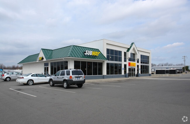
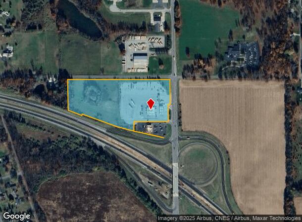
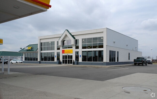
Property Record
15423 Us Highway 27 N, Marshall, MI 49068
NEARBY LISTINGS FOR SALE OR LEASE
Property Detail
15423 Us Highway 27 N
16-142-012-00
MARSHALL TWP SEC 14 T2S-R6W E 1250' OF SE 1/4 LYING NLY OF I-94 HWY ((EXCEPT COMM AT THE SE COR OF SEC 14, TH N89DEG14'28"W
Supermarket
Calhoun
X
Michigan
26025C0237C
12.13 AC
2024
Eastern Calhoun County
2025
West Michigan
003800
Battle Creek, MI
7,104 SF
DEMOGRAPHICS near 15423 Us Highway 27 N
1 Mile
3 Mile
5 Mile
2024 Total Population
1,016
9,038
12,149
2029 Population
1,004
8,934
11,996
Pop Growth 2024-2029
(1.18%)
(1.15%)
(1.26%)
Average Age
46
43
43
2024 Total Households
408
3,923
5,150
HH Growth 2024-2029
(1.23%)
(1.07%)
(1.18%)
Median Household Inc
$100,195
$69,363
$71,603
Avg Household Size
2.40
2.20
2.30
2024 Avg HH Vehicles
2.00
2.00
2.00
Median Home Value
$248,214
$185,435
$188,741
Median Year Built
1969
1958
1959
Nearby Places
Map Layers
Map Styles
 Street
 Aerial
- Restaurants
- Banks
- Shops
- Fitness
- Groceries
Nearby Properties
Address
Land Use
TOTAL SIZE
Lot Size
Zoning
Address
Land Use
TOTAL SIZE
Lot Size
Zoning
251,089 SF
15 AC
I-1
Address
Land Use
TOTAL SIZE
Lot Size
Zoning
89,699 SF
7.93 AC
B-4
Address
Land Use
TOTAL SIZE
Lot Size
Zoning
245,908 SF
11.46 AC
I-1
Address
Land Use
TOTAL SIZE
Lot Size
Zoning
50,700 SF
Address
Land Use
TOTAL SIZE
Lot Size
Zoning
80,288 SF
4.22 AC
MFRD
Address
Land Use
TOTAL SIZE
Lot Size
Zoning
241.30 AC
LI
Address
Land Use
TOTAL SIZE
Lot Size
Zoning
10,085 SF
3.88 AC
B4-GEN (IA
Address
Land Use
TOTAL SIZE
Lot Size
Zoning
111,882 SF
59.51 AC
I-2
Address
Land Use
TOTAL SIZE
Lot Size
Zoning
9,041 SF
30.30 AC
FS FREEWAY
Address
Land Use
TOTAL SIZE
Lot Size
Zoning
41,934 SF
11.21 AC
I-1
Address
Land Use
TOTAL SIZE
Lot Size
Zoning
59.25 AC
POSD
Address
Land Use
TOTAL SIZE
Lot Size
Zoning
310.28 AC
AR
Address
Land Use
TOTAL SIZE
Lot Size
Zoning
39,862 SF
2.88 AC
FS FREEWAY
Address
Land Use
TOTAL SIZE
Lot Size
Zoning
241.30 AC
LI
Address
Land Use
TOTAL SIZE
Lot Size
Zoning
54,612 SF
3.70 AC
MFRD
Address
Land Use
TOTAL SIZE
Lot Size
Zoning
74,904 SF
4.91 AC
MFRD
Address
Land Use
TOTAL SIZE
Lot Size
Zoning
45,659 SF
3.54 AC
B-4
Address
Land Use
TOTAL SIZE
Lot Size
Zoning
137,522 SF
14.15 AC
I-2
Address
Land Use
TOTAL SIZE
Lot Size
Zoning
33,400 SF
3.08 AC
B-4 GEN
Address
Land Use
TOTAL SIZE
Lot Size
Zoning
7,493 SF
1.26 AC
B4-GEN (IA
Address
Land Use
TOTAL SIZE
Lot Size
Zoning
2,091 SF
162.07 AC
AR
Address
Land Use
TOTAL SIZE
Lot Size
Zoning
16,740 SF
Address
Land Use
TOTAL SIZE
Lot Size
Zoning
14,788 SF
5 AC
Address
Land Use
TOTAL SIZE
Lot Size
Zoning
12,677 SF
2.46 AC
Address
Land Use
TOTAL SIZE
Lot Size
Zoning
46,198 SF
4.64 AC
B4-GEN (IA
Address
Land Use
TOTAL SIZE
Lot Size
Zoning
31,680 SF
1.81 AC
FS FREEWAY
Address
Land Use
TOTAL SIZE
Lot Size
Zoning
10,085 SF
3.88 AC
B4-GEN (IA
Address
Land Use
TOTAL SIZE
Lot Size
Zoning
20,250 SF
10.49 AC
Address
Land Use
TOTAL SIZE
Lot Size
Zoning
31,555 SF
2.02 AC
B-4 GEN
Address
Land Use
TOTAL SIZE
Lot Size
Zoning
162.10 AC
AR
The World's #1 Commercial Real Estate Marketplace
Connect with us
© 2026 CoStar Group
The information above has been obtained from sources believed reliable. While we do not doubt its accuracy we have not verified it and make no guarantee, warranty or representation about it. It is your responsibility to independently confirm its accuracy and completeness. Any projections, opinions, assumptions, or estimates used are for example only and do not represent the current or future performance of the property. The value of this transaction to you depends on tax and other factors which should be evaluated by your tax, financial, and legal advisors. You and your advisors should conduct a careful, independent investigation of the property to determine to your satisfaction the suitability of the property for your needs.