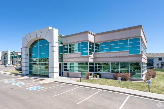
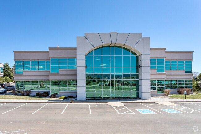
Property Record
15435 Gleneagle Dr, Colorado Springs, CO 80921


Current Lease Availabilities
Property Detail
15435 Gleneagle Dr
61312-10-022
LOT 3 BETHESDA MINISTRIES FIL NO 1
Officebuilding
EL PASO
R-4
Colorado
B and X Area of moderate flood hazard, usually the area between the limits of the 100-year and 500-year floods.
3
2025
1.08 AC
2026
Northeast
007204
Colorado Springs
15,032 SF
Colorado Springs, CO
NEARBY LISTINGS FOR SALE OR LEASE
DEMOGRAPHICS near 15435 Gleneagle Dr
1 mile
3 mile
5 mile
2025 Total Population
8,460
32,610
59,508
2030 Population
8,708
33,678
61,467
Pop Growth 2025-2030
+ 2.93%
+ 3.28%
+ 3.29%
Average Age
41
41
41
2025 Total Households
2,931
11,417
21,169
HH Growth 2025-2030
+ 3.21%
+ 3.53%
+ 3.57%
Median Household Inc
$167,187
$152,232
$150,126
Avg Household Size
2.90
2.80
2.80
2025 Avg HH Vehicles
3.00
2.00
2.00
Median Home Value
$697,309
$732,048
$754,986
Median Year Built
2001
2004
2004
Nearby Places
Map Layers
Map Styles
 Street
 Aerial
Layers
 Traffic
 Biking
Places
Listings with unknown addresses are not visible on the map
- Restaurants
- Banks
- Shops
- Fitness
- Groceries
PUBLIC TRANSPORTATION
AIRPORT
City of Colorado Springs Municipal
Drive
Walk
Distance
City of Colorado Springs Municipal
39 min
25.1 mi
Nearby Properties
Address
Land Use
TOTAL SIZE
Lot Size
Zoning
Address
Land Use
TOTAL SIZE
Lot Size
Zoning
154,703 SF
14.29 AC
BP HR
Address
Land Use
TOTAL SIZE
Lot Size
Zoning
136,906 SF
25.22 AC
PRD-4
Address
Land Use
TOTAL SIZE
Lot Size
Zoning
112,266 SF
0.24 AC
RR3
Address
Land Use
TOTAL SIZE
Lot Size
Zoning
323,646 SF
31.30 AC
A BP/CR BP
Address
Land Use
TOTAL SIZE
Lot Size
Zoning
45,186 SF
8.91 AC
PUD
Address
Land Use
TOTAL SIZE
Lot Size
Zoning
10,000 SF
23.39 AC
PUD
Address
Land Use
TOTAL SIZE
Lot Size
Zoning
248,689 SF
15.79 AC
Address
Land Use
TOTAL SIZE
Lot Size
Zoning
22,970 SF
5.45 AC
PUD
Address
Land Use
TOTAL SIZE
Lot Size
Zoning
188,626 SF
22.34 AC
BP/CR HR
Address
Land Use
TOTAL SIZE
Lot Size
Zoning
411,465 SF
22.54 AC
PDZ
Address
Land Use
TOTAL SIZE
Lot Size
Zoning
600 SF
25.36 AC
A
Address
Land Use
TOTAL SIZE
Lot Size
Zoning
23,378 SF
3.34 AC
PUD
Address
Land Use
TOTAL SIZE
Lot Size
Zoning
355,799 SF
10.51 AC
PDZ HR
Address
Land Use
TOTAL SIZE
Lot Size
Zoning
132,854 SF
10 AC
BP/CR HR
Address
Land Use
TOTAL SIZE
Lot Size
Zoning
20,752 SF
1.27 AC
BP HR
Address
Land Use
TOTAL SIZE
Lot Size
Zoning
222,850 SF
20.55 AC
PUD
Address
Land Use
TOTAL SIZE
Lot Size
Zoning
5.74 AC
MX-M
Address
Land Use
TOTAL SIZE
Lot Size
Zoning
347,470 SF
15.42 AC
PDZ HR
Address
Land Use
TOTAL SIZE
Lot Size
Zoning
13.14 AC
PUD
Address
Land Use
TOTAL SIZE
Lot Size
Zoning
150,335 SF
28 AC
LI
Address
Land Use
TOTAL SIZE
Lot Size
Zoning
17,655 SF
7.01 AC
R-4
Address
Land Use
TOTAL SIZE
Lot Size
Zoning
83,922 SF
16.29 AC
A
Address
Land Use
TOTAL SIZE
Lot Size
Zoning
14,684 SF
5 AC
RS-20000
Address
Land Use
TOTAL SIZE
Lot Size
Zoning
98,428 SF
16.92 AC
PUD
Address
Land Use
TOTAL SIZE
Lot Size
Zoning
4.97 AC
PDZ HR
Address
Land Use
TOTAL SIZE
Lot Size
Zoning
16,235 SF
6.08 AC
RR-5
Address
Land Use
TOTAL SIZE
Lot Size
Zoning
119,596 SF
19.25 AC
PDZ HR
Address
Land Use
TOTAL SIZE
Lot Size
Zoning
9.62 AC
PID
Address
Land Use
TOTAL SIZE
Lot Size
Zoning
16,230 SF
2.81 AC
Address
Land Use
TOTAL SIZE
Lot Size
Zoning
222,866 SF
14.40 AC
RM-30
The World's #1 Commercial Real Estate Marketplace
Connect with us
© 2026 CoStar Group
The information above has been obtained from sources believed reliable. While we do not doubt its accuracy we have not verified it and make no guarantee, warranty or representation about it. It is your responsibility to independently confirm its accuracy and completeness. Any projections, opinions, assumptions, or estimates used are for example only and do not represent the current or future performance of the property. The value of this transaction to you depends on tax and other factors which should be evaluated by your tax, financial, and legal advisors. You and your advisors should conduct a careful, independent investigation of the property to determine to your satisfaction the suitability of the property for your needs.