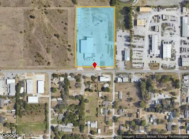
Property Record
15437 E Pine St, Tulsa, OK 74116
Property Detail
15437 E Pine St
Tulsa
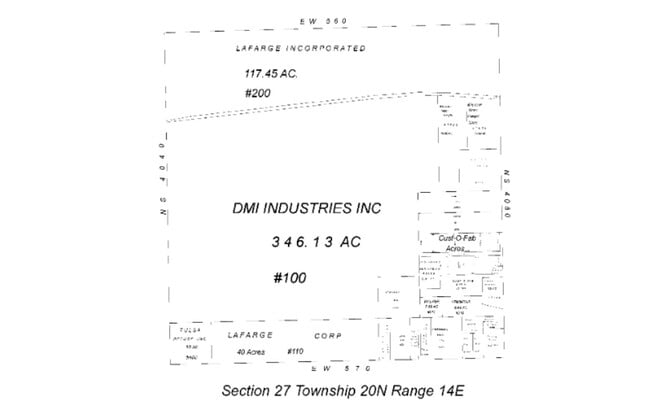
Dmi Samurai Addition
Tulsa, OK
LOT 1 BLOCK 1 DMI-SAMURAI ADDITION
0102215
Rogers
Manufacturinglight
Oklahoma
2025
1
2025
5.50 AC
050407
Rogers County
17,994 SF
NEARBY LISTINGS FOR SALE OR LEASE
DEMOGRAPHICS near 15437 E Pine St
1 mile
3 mile
5 mile
2024 Total Population
1,123
12,819
64,161
2029 Population
1,220
13,472
66,915
Pop Growth 2024-2029
+ 8.64%
+ 5.09%
+ 4.29%
Average Age
42
38
35
2024 Total Households
420
4,702
23,250
HH Growth 2024-2029
+ 8.81%
+ 5.23%
+ 4.44%
Median Household Inc
$78,345
$53,659
$48,858
Avg Household Size
2.70
2.60
2.70
2024 Avg HH Vehicles
2.00
2.00
2.00
Median Home Value
$169,940
$142,770
$121,344
Median Year Built
1980
1973
1973
Nearby Places
Map Layers
Map Styles
 Street
 Aerial
Transit
 Traffic
 Biking
Places
Listings with unknown addresses are not visible on the map
- Restaurants
- Banks
- Shops
- Fitness
- Groceries
PUBLIC TRANSPORTATION
AIRPORT
Tulsa International
Drive
Walk
Distance
Tulsa International
15 min
9.6 mi
Freight Ports
Tulsa Port Of Catoosa
Drive
Walk
Distance
Tulsa Port Of Catoosa
12 min
7.3 mi
Nearby Properties
Address
Land Use
TOTAL SIZE
Lot Size
Zoning
Address
Land Use
TOTAL SIZE
Lot Size
Zoning
349,823 SF
203.39 AC
IL
Address
Land Use
TOTAL SIZE
Lot Size
Zoning
725,973 SF
122.30 AC
IM
Address
Land Use
TOTAL SIZE
Lot Size
Zoning
112,556 SF
11.07 AC
CH
Address
Land Use
TOTAL SIZE
Lot Size
Zoning
11,184 SF
638.56 AC
Address
Land Use
TOTAL SIZE
Lot Size
Zoning
106,270 SF
9.47 AC
RM0
Address
Land Use
TOTAL SIZE
Lot Size
Zoning
124,648 SF
21.23 AC
IL
Address
Land Use
TOTAL SIZE
Lot Size
Zoning
32,370 SF
45.90 AC
AG
Address
Land Use
TOTAL SIZE
Lot Size
Zoning
28,465 SF
6.71 AC
RS3
Address
Land Use
TOTAL SIZE
Lot Size
Zoning
56,531 SF
7.79 AC
RS3
Address
Land Use
TOTAL SIZE
Lot Size
Zoning
673,050 SF
52.77 AC
IM
Address
Land Use
TOTAL SIZE
Lot Size
Zoning
40,202 SF
2.93 AC
RM0
Address
Land Use
TOTAL SIZE
Lot Size
Zoning
371,153 SF
22.82 AC
IL
Address
Land Use
TOTAL SIZE
Lot Size
Zoning
22,825 SF
2.38 AC
CS
Address
Land Use
TOTAL SIZE
Lot Size
Zoning
129,087 SF
43.40 AC
IR
Address
Land Use
TOTAL SIZE
Lot Size
Zoning
492,786 SF
76.58 AC
IL
Address
Land Use
TOTAL SIZE
Lot Size
Zoning
3,720 SF
158.66 AC
Address
Land Use
TOTAL SIZE
Lot Size
Zoning
219,538 SF
20.13 AC
IL
Address
Land Use
TOTAL SIZE
Lot Size
Zoning
10,674 SF
14.18 AC
RS3
Address
Land Use
TOTAL SIZE
Lot Size
Zoning
6,000 SF
346.13 AC
Address
Land Use
TOTAL SIZE
Lot Size
Zoning
4,125 SF
54.35 AC
CS
Address
Land Use
TOTAL SIZE
Lot Size
Zoning
137,668 SF
13.67 AC
IM
Address
Land Use
TOTAL SIZE
Lot Size
Zoning
34,595 SF
4.35 AC
CS
Address
Land Use
TOTAL SIZE
Lot Size
Zoning
6,000 SF
0.38 AC
Address
Land Use
TOTAL SIZE
Lot Size
Zoning
439,510 SF
57.22 AC
IM
Address
Land Use
TOTAL SIZE
Lot Size
Zoning
20,174 SF
1.12 AC
RS3
Address
Land Use
TOTAL SIZE
Lot Size
Zoning
64.90 AC
AG
Address
Land Use
TOTAL SIZE
Lot Size
Zoning
62,644 SF
12 AC
Address
Land Use
TOTAL SIZE
Lot Size
Zoning
125,440 SF
7.32 AC
IM
Address
Land Use
TOTAL SIZE
Lot Size
Zoning
153,297 SF
16.29 AC
Address
Land Use
TOTAL SIZE
Lot Size
Zoning
13,735 SF
2.72 AC
CS
The World's #1 Commercial Real Estate Marketplace
Connect with us
© 2026 CoStar Group
The information above has been obtained from sources believed reliable. While we do not doubt its accuracy we have not verified it and make no guarantee, warranty or representation about it. It is your responsibility to independently confirm its accuracy and completeness. Any projections, opinions, assumptions, or estimates used are for example only and do not represent the current or future performance of the property. The value of this transaction to you depends on tax and other factors which should be evaluated by your tax, financial, and legal advisors. You and your advisors should conduct a careful, independent investigation of the property to determine to your satisfaction the suitability of the property for your needs.