Property Record
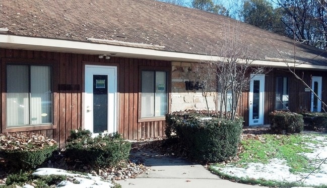
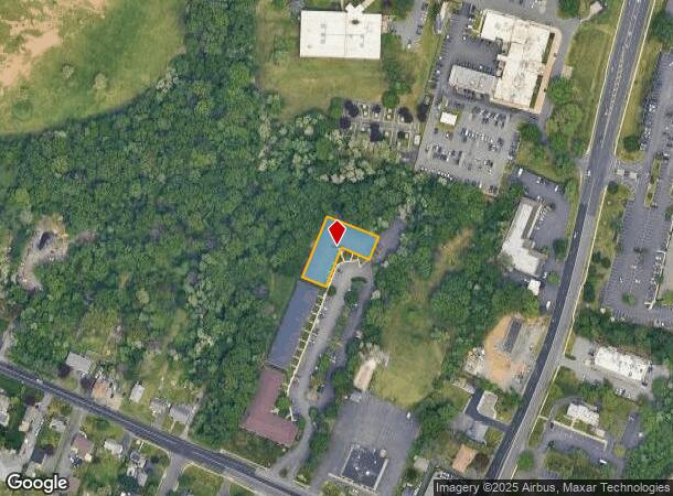
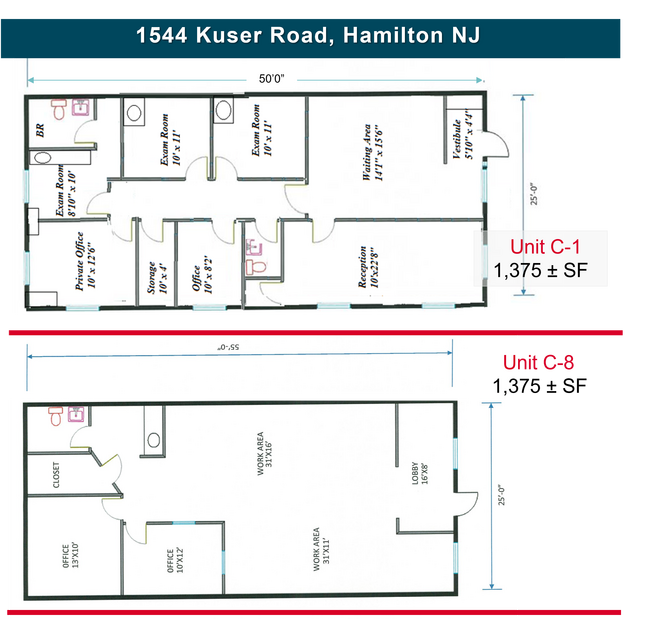
1544 Kuser Rd, Trenton, NJ 08619

Current Lease Availabilities
NEARBY LISTINGS FOR SALE OR LEASE
Property Detail
1544 Kuser Rd
Trenton-Princeton, NJ
Center City Office Park Condo
03-02163-0000-00054
FACILITY NAME: DEED# 136714
Vacantlandnec
Mercer
X
New Jersey
34021C0229F
54
2024
0.30 AC
2025
Trenton
002702
Northern New Jersey
13,970 SF
DEMOGRAPHICS near 1544 Kuser Rd
1 mile
3 mile
5 mile
2024 Total Population
10,909
119,518
227,963
2029 Population
10,795
117,193
225,348
Pop Growth 2024-2029
(1.05%)
(1.95%)
(1.15%)
Average Age
44
40
40
2024 Total Households
5,063
43,070
83,658
HH Growth 2024-2029
(1.30%)
(2.04%)
(1.20%)
Median Household Inc
$75,659
$75,850
$72,909
Avg Household Size
2.10
2.70
2.60
2024 Avg HH Vehicles
2.00
2.00
2.00
Median Home Value
$250,043
$244,365
$256,221
Median Year Built
1974
1956
1957
Nearby Places
Map Layers
Map Styles
 Street
 Aerial
Transit
 Traffic
 Biking
Places
Listings with unknown addresses are not visible on the map
- Restaurants
- Banks
- Shops
- Fitness
- Groceries
PUBLIC TRANSPORTATION
COMMUTER RAIL
Trenton Transit Center (NJT) (Northeast Corridor Line - NJ Transit Commuter Rail (NJ Transit), River LINE - River LINE (River LINE))
Drive
Walk
Distance
Trenton Transit Center (NJT) (Northeast Corridor Line - NJ Transit Commuter Rail (NJ Transit), River LINE - River LINE (River LINE))
10 min
4.2 mi
Drive
Walk
Distance
9 min
4.2 mi
AIRPORT
Trenton Mercer
Drive
Walk
Distance
Trenton Mercer
21 min
10.0 mi
Philadelphia International
Drive
Walk
Distance
Philadelphia International
65 min
45.5 mi
Freight Ports
South Jersey Port
Drive
Walk
Distance
South Jersey Port
48 min
35.3 mi
Nearby Properties
Address
Land Use
TOTAL SIZE
Lot Size
Zoning
Address
Land Use
TOTAL SIZE
Lot Size
Zoning
Address
Land Use
TOTAL SIZE
Lot Size
Zoning
23.13 AC
RD
Address
Land Use
TOTAL SIZE
Lot Size
Zoning
35.83 AC
RB
Address
Land Use
TOTAL SIZE
Lot Size
Zoning
30.94 AC
Address
Land Use
TOTAL SIZE
Lot Size
Zoning
60.26 AC
RD
Address
Land Use
TOTAL SIZE
Lot Size
Zoning
44.82 AC
RD
Address
Land Use
TOTAL SIZE
Lot Size
Zoning
2,030 SF
45.57 AC
Address
Land Use
TOTAL SIZE
Lot Size
Zoning
Address
Land Use
TOTAL SIZE
Lot Size
Zoning
18.33 AC
Address
Land Use
TOTAL SIZE
Lot Size
Zoning
17.84 AC
HC
Address
Land Use
TOTAL SIZE
Lot Size
Zoning
1,836 SF
33.91 AC
RD
Address
Land Use
TOTAL SIZE
Lot Size
Zoning
9.63 AC
RD
Address
Land Use
TOTAL SIZE
Lot Size
Zoning
23.53 AC
AT
Address
Land Use
TOTAL SIZE
Lot Size
Zoning
27.50 AC
R7
Address
Land Use
TOTAL SIZE
Lot Size
Zoning
Address
Land Use
TOTAL SIZE
Lot Size
Zoning
6.79 AC
R7
Address
Land Use
TOTAL SIZE
Lot Size
Zoning
15.80 AC
C
Address
Land Use
TOTAL SIZE
Lot Size
Zoning
21.62 AC
RD
Address
Land Use
TOTAL SIZE
Lot Size
Zoning
Address
Land Use
TOTAL SIZE
Lot Size
Zoning
156,128 SF
6.33 AC
RB
Address
Land Use
TOTAL SIZE
Lot Size
Zoning
Address
Land Use
TOTAL SIZE
Lot Size
Zoning
17,500 SF
18.14 AC
HC
Address
Land Use
TOTAL SIZE
Lot Size
Zoning
9.31 AC
HC
Address
Land Use
TOTAL SIZE
Lot Size
Zoning
16.62 AC
Address
Land Use
TOTAL SIZE
Lot Size
Zoning
60,564 SF
18.37 AC
RD
Address
Land Use
TOTAL SIZE
Lot Size
Zoning
77,722 SF
39.13 AC
Address
Land Use
TOTAL SIZE
Lot Size
Zoning
14,574 SF
20.23 AC
R10
Address
Land Use
TOTAL SIZE
Lot Size
Zoning
2.89 AC
RD
Address
Land Use
TOTAL SIZE
Lot Size
Zoning
21.91 AC
R10
Address
Land Use
TOTAL SIZE
Lot Size
Zoning
22.39 AC
I
The World's #1 Commercial Real Estate Marketplace
Connect with us
© 2026 CoStar Group
The information above has been obtained from sources believed reliable. While we do not doubt its accuracy we have not verified it and make no guarantee, warranty or representation about it. It is your responsibility to independently confirm its accuracy and completeness. Any projections, opinions, assumptions, or estimates used are for example only and do not represent the current or future performance of the property. The value of this transaction to you depends on tax and other factors which should be evaluated by your tax, financial, and legal advisors. You and your advisors should conduct a careful, independent investigation of the property to determine to your satisfaction the suitability of the property for your needs.