Property Record
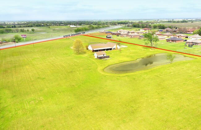
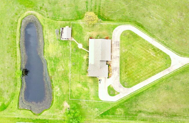
15440 State Highway 198, Mabank, TX 75147

Property Detail
15440 State Highway 198
8417
GEO ISAAC, TRACT 140.03; 8.65 ACRES, & HOUSE
Agriculturalland
Van Zandt
B and X Area of moderate flood hazard, usually the area between the limits of the 100-year and 500-year floods.
Texas
2024
8.65 AC
2025
Outlying Kaufman County
051301
Dallas/Ft Worth
3,378 SF
Dallas-Fort Worth-Arlington, TX
NEARBY LISTINGS FOR SALE OR LEASE
-
-
View all Mabank listings for sale on LoopNet.com
DEMOGRAPHICS near 15440 State Highway 198
1 mile
3 mile
5 mile
2025 Total Population
1,452
5,957
12,699
2030 Population
1,863
7,460
15,103
Pop Growth 2025-2030
+ 28.31%
+ 25.23%
+ 18.93%
Average Age
37
39
40
2025 Total Households
510
2,150
4,711
HH Growth 2025-2030
+ 26.08%
+ 23.16%
+ 17.17%
Median Household Inc
$68,863
$69,090
$67,055
Avg Household Size
2.70
2.60
2.60
2025 Avg HH Vehicles
2.00
2.00
2.00
Median Home Value
$309,596
$308,133
$285,190
Median Year Built
1991
1993
1991
Nearby Places
Map Layers
Map Styles
 Street
 Aerial
Layers
 Traffic
 Biking
Places
Listings with unknown addresses are not visible on the map
- Restaurants
- Banks
- Shops
- Fitness
- Groceries
SALE & LEASE HISTORY
LISTING DATE
SALE/LEASE

Jul 27, 2022
For Sale
Apr 08, 2021
For Sale
Nearby Properties
Address
Land Use
TOTAL SIZE
Lot Size
Zoning
Address
Land Use
TOTAL SIZE
Lot Size
Zoning
100,720 SF
18.73 AC
Address
Land Use
TOTAL SIZE
Lot Size
Zoning
80,885 SF
6.73 AC
Address
Land Use
TOTAL SIZE
Lot Size
Zoning
38,369 SF
8 AC
Address
Land Use
TOTAL SIZE
Lot Size
Zoning
62,044 SF
8.90 AC
Address
Land Use
TOTAL SIZE
Lot Size
Zoning
1,034 SF
22.77 AC
Address
Land Use
TOTAL SIZE
Lot Size
Zoning
35,084 SF
3.46 AC
Address
Land Use
TOTAL SIZE
Lot Size
Zoning
5,300 SF
39.59 AC
Address
Land Use
TOTAL SIZE
Lot Size
Zoning
32,987 SF
0.15 AC
Address
Land Use
TOTAL SIZE
Lot Size
Zoning
14,300 SF
7.26 AC
Address
Land Use
TOTAL SIZE
Lot Size
Zoning
69,048 SF
1.77 AC
Address
Land Use
TOTAL SIZE
Lot Size
Zoning
70,412 SF
2 AC
Address
Land Use
TOTAL SIZE
Lot Size
Zoning
7,218 SF
1.58 AC
Address
Land Use
TOTAL SIZE
Lot Size
Zoning
10,820 SF
0.86 AC
Address
Land Use
TOTAL SIZE
Lot Size
Zoning
2.65 AC
Address
Land Use
TOTAL SIZE
Lot Size
Zoning
24,320 SF
2.10 AC
Address
Land Use
TOTAL SIZE
Lot Size
Zoning
336 SF
1.19 AC
Address
Land Use
TOTAL SIZE
Lot Size
Zoning
3,600 SF
1.23 AC
Address
Land Use
TOTAL SIZE
Lot Size
Zoning
11,250 SF
3.22 AC
Address
Land Use
TOTAL SIZE
Lot Size
Zoning
7,200 SF
1.39 AC
Address
Land Use
TOTAL SIZE
Lot Size
Zoning
16,300 SF
5.60 AC
Address
Land Use
TOTAL SIZE
Lot Size
Zoning
17,105 SF
0.66 AC
Address
Land Use
TOTAL SIZE
Lot Size
Zoning
124.05 AC
Address
Land Use
TOTAL SIZE
Lot Size
Zoning
Address
Land Use
TOTAL SIZE
Lot Size
Zoning
5,200 SF
3.55 AC
Address
Land Use
TOTAL SIZE
Lot Size
Zoning
4,870 SF
1.34 AC
Address
Land Use
TOTAL SIZE
Lot Size
Zoning
8,525 SF
0.40 AC
Address
Land Use
TOTAL SIZE
Lot Size
Zoning
9,600 SF
0.40 AC
Address
Land Use
TOTAL SIZE
Lot Size
Zoning
7,856 SF
9.20 AC
The World's #1 Commercial Real Estate Marketplace
Connect with us
© 2026 CoStar Group
The information above has been obtained from sources believed reliable. While we do not doubt its accuracy we have not verified it and make no guarantee, warranty or representation about it. It is your responsibility to independently confirm its accuracy and completeness. Any projections, opinions, assumptions, or estimates used are for example only and do not represent the current or future performance of the property. The value of this transaction to you depends on tax and other factors which should be evaluated by your tax, financial, and legal advisors. You and your advisors should conduct a careful, independent investigation of the property to determine to your satisfaction the suitability of the property for your needs.