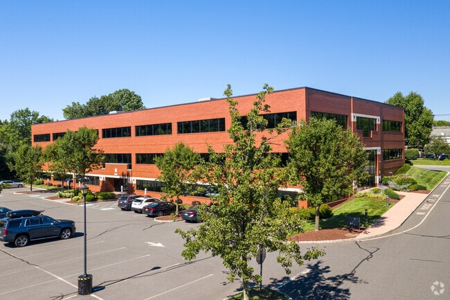
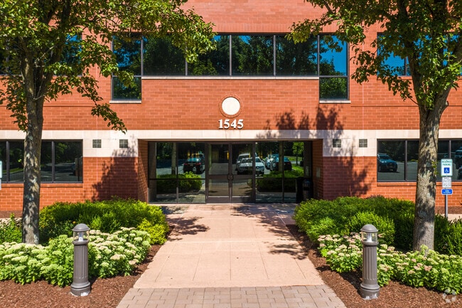
Property Record
1545 Route 206, Bedminster, NJ 07921


Property Detail
1545 Route 206
01-00022-0000-00038
ALSO LOT 38.1
Vacantlandnec
SOMERSET
OR
New Jersey
B and X Area of moderate flood hazard, usually the area between the limits of the 100-year and 500-year floods.
38
2024
3.37 AC
2025
Route 78 East
052904
Northern New Jersey
1,530 SF
Lakewood-New Brunswick, NJ
NEARBY LISTINGS FOR SALE OR LEASE
DEMOGRAPHICS near 1545 Route 206
1 mile
3 mile
5 mile
2025 Total Population
1,564
16,044
41,085
2030 Population
1,574
16,539
42,407
Pop Growth 2025-2030
+ 0.64%
+ 3.09%
+ 3.22%
Average Age
45
44
43
2025 Total Households
599
6,893
15,729
HH Growth 2025-2030
+ 0.83%
+ 3.34%
+ 3.39%
Median Household Inc
$131,081
$145,967
$177,834
Avg Household Size
2.60
2.30
2.60
2025 Avg HH Vehicles
2.00
2.00
2.00
Median Home Value
$876,727
$667,179
$744,862
Median Year Built
1959
1987
1983
Nearby Places
Map Layers
Map Styles
 Street
 Aerial
Transit
 Traffic
 Biking
Places
Listings with unknown addresses are not visible on the map
- Restaurants
- Banks
- Shops
- Fitness
- Groceries
SALE & LEASE HISTORY
LISTING DATE
SALE/LEASE

Sep 24, 2016
For Lease
Sep 24, 2016
For Lease
Oct 06, 2022
For Lease
Jul 12, 2019
For Lease
Nearby Properties
Address
Land Use
TOTAL SIZE
Lot Size
Zoning
Address
Land Use
TOTAL SIZE
Lot Size
Zoning
196.68 AC
OR
Address
Land Use
TOTAL SIZE
Lot Size
Zoning
44.48 AC
ORL
Address
Land Use
TOTAL SIZE
Lot Size
Zoning
23.08 AC
OR
Address
Land Use
TOTAL SIZE
Lot Size
Zoning
12.74 AC
PUD
Address
Land Use
TOTAL SIZE
Lot Size
Zoning
13.94 AC
PUD
Address
Land Use
TOTAL SIZE
Lot Size
Zoning
243.82 AC
R10
Address
Land Use
TOTAL SIZE
Lot Size
Zoning
2,848 SF
22.47 AC
ORVM
Address
Land Use
TOTAL SIZE
Lot Size
Zoning
17.63 AC
OR
Address
Land Use
TOTAL SIZE
Lot Size
Zoning
10,995 SF
14.26 AC
RE
Address
Land Use
TOTAL SIZE
Lot Size
Zoning
2,726 SF
10.01 AC
VN
Address
Land Use
TOTAL SIZE
Lot Size
Zoning
49,786 SF
13.84 AC
VN2
Address
Land Use
TOTAL SIZE
Lot Size
Zoning
32,578 SF
298.72 AC
R10
Address
Land Use
TOTAL SIZE
Lot Size
Zoning
12 AC
P3
Address
Land Use
TOTAL SIZE
Lot Size
Zoning
31.95 AC
R3
Address
Land Use
TOTAL SIZE
Lot Size
Zoning
30,298 SF
33.47 AC
R10
Address
Land Use
TOTAL SIZE
Lot Size
Zoning
10,266 SF
3 AC
R10
Address
Land Use
TOTAL SIZE
Lot Size
Zoning
3.90 AC
PUD
Address
Land Use
TOTAL SIZE
Lot Size
Zoning
5,398 SF
4.90 AC
VN
Address
Land Use
TOTAL SIZE
Lot Size
Zoning
60,506 SF
10.44 AC
PUD5
Address
Land Use
TOTAL SIZE
Lot Size
Zoning
3.88 AC
VN
Address
Land Use
TOTAL SIZE
Lot Size
Zoning
15,062 SF
266.92 AC
PUD5
Address
Land Use
TOTAL SIZE
Lot Size
Zoning
22,833 SF
7 AC
R110
Address
Land Use
TOTAL SIZE
Lot Size
Zoning
185.18 AC
P1
Address
Land Use
TOTAL SIZE
Lot Size
Zoning
11,337 SF
14 AC
R10
Address
Land Use
TOTAL SIZE
Lot Size
Zoning
9.35 AC
OR
Address
Land Use
TOTAL SIZE
Lot Size
Zoning
23.10 AC
LI
Address
Land Use
TOTAL SIZE
Lot Size
Zoning
3,444 SF
122.02 AC
P
Address
Land Use
TOTAL SIZE
Lot Size
Zoning
12,566 SF
4 AC
R10
Address
Land Use
TOTAL SIZE
Lot Size
Zoning
9,091 SF
6.78 AC
R10
The World's #1 Commercial Real Estate Marketplace
Connect with us
© 2026 CoStar Group
The information above has been obtained from sources believed reliable. While we do not doubt its accuracy we have not verified it and make no guarantee, warranty or representation about it. It is your responsibility to independently confirm its accuracy and completeness. Any projections, opinions, assumptions, or estimates used are for example only and do not represent the current or future performance of the property. The value of this transaction to you depends on tax and other factors which should be evaluated by your tax, financial, and legal advisors. You and your advisors should conduct a careful, independent investigation of the property to determine to your satisfaction the suitability of the property for your needs.