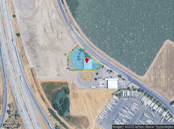
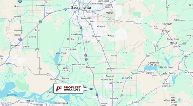
Property Record
15453 N Thornton Rd, Lodi, CA 95242
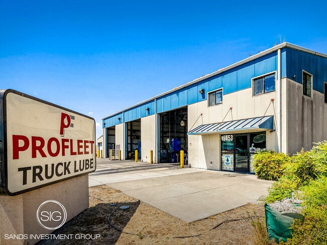
This Property Is For Sale
NEARBY LISTINGS FOR SALE OR LEASE
-
-
View all Lodi listings for sale on LoopNet.com
Property Detail
15453 N Thornton Rd
025-190-06
REDRAWN JUL-12-2006 FROM ORIGINAL APN 025-130-94
Autorepair
San Joaquin
X
California
06077C0285F
1.33 AC
2025
Lodi
2025
Stockton/Modesto
004106
Stockton-Lodi, CA
DEMOGRAPHICS near 15453 N Thornton Rd
1 Mile
3 Mile
5 Mile
2024 Total Population
24
448
13,354
2029 Population
25
468
14,991
Pop Growth 2024-2029
+ 4.17%
+ 4.46%
+ 12.26%
Average Age
48
44
40
2024 Total Households
9
168
4,385
HH Growth 2024-2029
0.00%
+ 4.17%
+ 12.11%
Median Household Inc
$59,999
$107,143
$118,393
Avg Household Size
2.30
2.60
3.00
2024 Avg HH Vehicles
3.00
3.00
2.00
Median Home Value
$399,999
$806,034
$689,475
Median Year Built
1980
1970
2003
Nearby Places
Map Layers
Map Styles
 Street
 Aerial
- Restaurants
- Banks
- Shops
- Fitness
- Groceries
PUBLIC TRANSPORTATION
COMMUTER RAIL
Lodi Amtrak Station (San Joaquins - Amtrak)
DRIVE
WALK
Distance
Lodi Amtrak Station (San Joaquins - Amtrak)
13 min
8.2 mi
AIRPORT
Stockton Metro
DRIVE
WALK
Distance
Stockton Metro
27 min
21.0 mi
Freight Ports
Port of Stockton
DRIVE
WALK
Distance
Port of Stockton
17 min
13.4 mi
Nearby Properties
Address
Land Use
TOTAL SIZE
Lot Size
Zoning
Address
Land Use
TOTAL SIZE
Lot Size
Zoning
17,550 SF
151.12 AC
Address
Land Use
TOTAL SIZE
Lot Size
Zoning
3,058 SF
23.77 AC
AG40
Address
Land Use
TOTAL SIZE
Lot Size
Zoning
17,638 SF
19.62 AC
CFS
Address
Land Use
TOTAL SIZE
Lot Size
Zoning
29,913 SF
0.83 AC
CFS
Address
Land Use
TOTAL SIZE
Lot Size
Zoning
10,740 SF
3.14 AC
CFS
Address
Land Use
TOTAL SIZE
Lot Size
Zoning
260 AC
AG40
Address
Land Use
TOTAL SIZE
Lot Size
Zoning
76.49 AC
AG40
Address
Land Use
TOTAL SIZE
Lot Size
Zoning
800 SF
322.05 AC
AG40
Address
Land Use
TOTAL SIZE
Lot Size
Zoning
388.89 AC
AG40
Address
Land Use
TOTAL SIZE
Lot Size
Zoning
3,040 SF
4.45 AC
CFS
Address
Land Use
TOTAL SIZE
Lot Size
Zoning
3,321 SF
13.19 AC
CFS
Address
Land Use
TOTAL SIZE
Lot Size
Zoning
2,740 SF
38.04 AC
AG40
Address
Land Use
TOTAL SIZE
Lot Size
Zoning
23,273 SF
0.97 AC
CFS
Address
Land Use
TOTAL SIZE
Lot Size
Zoning
7,000 SF
61.87 AC
AG40
Address
Land Use
TOTAL SIZE
Lot Size
Zoning
30.60 AC
IT
Address
Land Use
TOTAL SIZE
Lot Size
Zoning
39.96 AC
Address
Land Use
TOTAL SIZE
Lot Size
Zoning
101.45 AC
AG40
Address
Land Use
TOTAL SIZE
Lot Size
Zoning
4.96 AC
AG40
Address
Land Use
TOTAL SIZE
Lot Size
Zoning
6,022 SF
1.46 AC
CFS
Address
Land Use
TOTAL SIZE
Lot Size
Zoning
396.34 AC
AG40
Address
Land Use
TOTAL SIZE
Lot Size
Zoning
3,253 SF
1.05 AC
CFS
Address
Land Use
TOTAL SIZE
Lot Size
Zoning
10,330 SF
10.31 AC
Address
Land Use
TOTAL SIZE
Lot Size
Zoning
34.31 AC
Address
Land Use
TOTAL SIZE
Lot Size
Zoning
3,255 SF
7 AC
IT
Address
Land Use
TOTAL SIZE
Lot Size
Zoning
369.74 AC
AG40
Address
Land Use
TOTAL SIZE
Lot Size
Zoning
869 SF
221.16 AC
AG40
Address
Land Use
TOTAL SIZE
Lot Size
Zoning
155.82 AC
AG40
The World's #1 Commercial Real Estate Marketplace
Connect with us
© 2026 CoStar Group
The information above has been obtained from sources believed reliable. While we do not doubt its accuracy we have not verified it and make no guarantee, warranty or representation about it. It is your responsibility to independently confirm its accuracy and completeness. Any projections, opinions, assumptions, or estimates used are for example only and do not represent the current or future performance of the property. The value of this transaction to you depends on tax and other factors which should be evaluated by your tax, financial, and legal advisors. You and your advisors should conduct a careful, independent investigation of the property to determine to your satisfaction the suitability of the property for your needs.