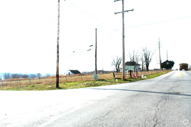
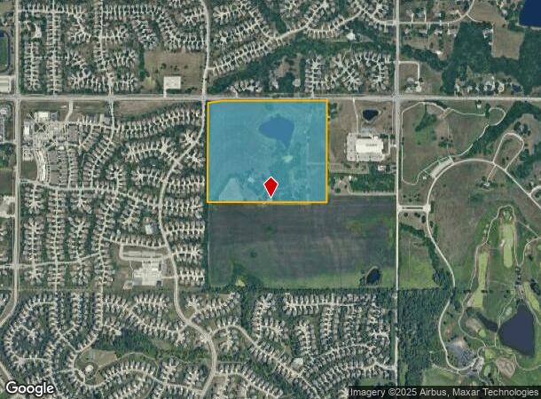
Property Record
15455 W 159Th St, Olathe, KS 66062
NEARBY LISTINGS FOR SALE OR LEASE
-
-
-
No Photo
-
-
-
-
-
View all Olathe listings for sale on LoopNet.com
Property Detail
15455 W 159Th St
6F241417-3006
17-14-24 BG NW CR NE1/4 E 1639.14' TO NE CR W1/2 W1/2 NE1/4 NE1/4 S 1415.87' TO PT 83.25' S SE CR W1/2 W1/2 NE1/4NE1/4 W 1641.46' TO W/L NE1/4 & 83.2 5' SSE CR NW1/4 NE1/4 N1411.97' TO POB EX .0639 AC FOR ST EX 0.2819 AC IN RD (159TH ST) 52.8962 ACS
Farms
Johnson
X
Kansas
20091C0110G
52.43 AC
2024
South Johnson County
2024
Kansas City
053560
Kansas City, MO-KS
8,698 SF
DEMOGRAPHICS near 15455 W 159Th St
1 Mile
3 Mile
5 Mile
2024 Total Population
9,311
65,246
149,648
2029 Population
9,685
68,157
156,049
Pop Growth 2024-2029
+ 4.02%
+ 4.46%
+ 4.28%
Average Age
35
37
37
2024 Total Households
2,882
21,556
52,297
HH Growth 2024-2029
+ 4.09%
+ 4.51%
+ 4.33%
Median Household Inc
$146,104
$123,608
$108,002
Avg Household Size
3.20
2.90
2.80
2024 Avg HH Vehicles
2.00
2.00
2.00
Median Home Value
$352,712
$329,050
$346,171
Median Year Built
2004
1997
1994
Nearby Places
Map Layers
Map Styles
 Street
 Aerial
- Restaurants
- Banks
- Shops
- Fitness
- Groceries
Nearby Properties
Address
Land Use
TOTAL SIZE
Lot Size
Zoning
Address
Land Use
TOTAL SIZE
Lot Size
Zoning
320,892 SF
74.58 AC
R-1
Address
Land Use
TOTAL SIZE
Lot Size
Zoning
512,643 SF
75.55 AC
AG
Address
Land Use
TOTAL SIZE
Lot Size
Zoning
211,054 SF
77.48 AC
R-1
Address
Land Use
TOTAL SIZE
Lot Size
Zoning
143,207 SF
16.19 AC
R-1
Address
Land Use
TOTAL SIZE
Lot Size
Zoning
103,102 SF
31.90 AC
R-1
Address
Land Use
TOTAL SIZE
Lot Size
Zoning
129,325 SF
4.50 AC
R-1
Address
Land Use
TOTAL SIZE
Lot Size
Zoning
137,955 SF
23.80 AC
R-1
Address
Land Use
TOTAL SIZE
Lot Size
Zoning
150,122 SF
17.48 AC
R-1
Address
Land Use
TOTAL SIZE
Lot Size
Zoning
934,106 SF
34.09 AC
BP
Address
Land Use
TOTAL SIZE
Lot Size
Zoning
157,344 SF
12.69 AC
R-1
Address
Land Use
TOTAL SIZE
Lot Size
Zoning
130,605 SF
18.01 AC
R-1
Address
Land Use
TOTAL SIZE
Lot Size
Zoning
86,095 SF
16.95 AC
R-1
Address
Land Use
TOTAL SIZE
Lot Size
Zoning
71,221 SF
17.13 AC
R-1
Address
Land Use
TOTAL SIZE
Lot Size
Zoning
117,084 SF
10.69 AC
R-1
Address
Land Use
TOTAL SIZE
Lot Size
Zoning
71,221 SF
13.84 AC
R-1
Address
Land Use
TOTAL SIZE
Lot Size
Zoning
81,753 SF
20.88 AC
R-1
Address
Land Use
TOTAL SIZE
Lot Size
Zoning
73,159 SF
12.54 AC
R-1
Address
Land Use
TOTAL SIZE
Lot Size
Zoning
81,096 SF
121.93 AC
AG
Address
Land Use
TOTAL SIZE
Lot Size
Zoning
72,091 SF
11.33 AC
R-1
Address
Land Use
TOTAL SIZE
Lot Size
Zoning
69,723 SF
11.29 AC
R-1
Address
Land Use
TOTAL SIZE
Lot Size
Zoning
62,832 SF
15.43 AC
CTY RUR
Address
Land Use
TOTAL SIZE
Lot Size
Zoning
65,691 SF
11.51 AC
RP-1
Address
Land Use
TOTAL SIZE
Lot Size
Zoning
54,005 SF
10.49 AC
R-1/PUD
Address
Land Use
TOTAL SIZE
Lot Size
Zoning
36,920 SF
31.22 AC
R-1
Address
Land Use
TOTAL SIZE
Lot Size
Zoning
24,144 SF
11.10 AC
RP-3
Address
Land Use
TOTAL SIZE
Lot Size
Zoning
54,585 SF
10.52 AC
RRJ
Address
Land Use
TOTAL SIZE
Lot Size
Zoning
418,969 SF
48.14 AC
M-2
Address
Land Use
TOTAL SIZE
Lot Size
Zoning
26,910 SF
26.56 AC
R-1
Address
Land Use
TOTAL SIZE
Lot Size
Zoning
44,364 SF
22.16 AC
AG
Address
Land Use
TOTAL SIZE
Lot Size
Zoning
40,543 SF
9.56 AC
R-1
The World's #1 Commercial Real Estate Marketplace
Connect with us
© 2025 CoStar Group
The information above has been obtained from sources believed reliable. While we do not doubt its accuracy we have not verified it and make no guarantee, warranty or representation about it. It is your responsibility to independently confirm its accuracy and completeness. Any projections, opinions, assumptions, or estimates used are for example only and do not represent the current or future performance of the property. The value of this transaction to you depends on tax and other factors which should be evaluated by your tax, financial, and legal advisors. You and your advisors should conduct a careful, independent investigation of the property to determine to your satisfaction the suitability of the property for your needs.