Property Record
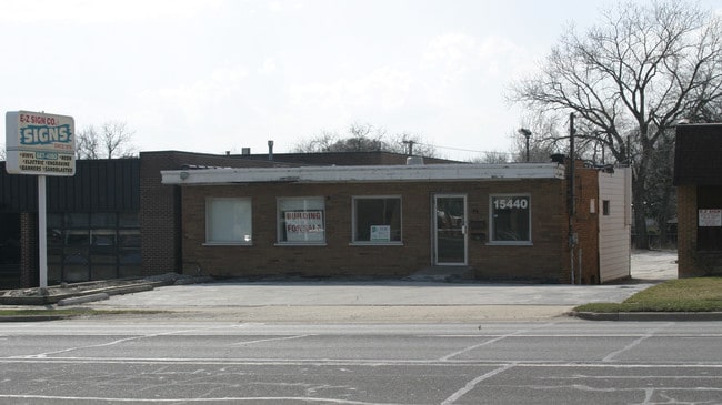
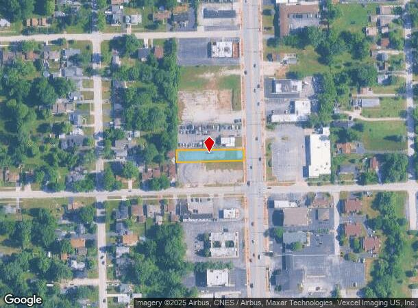
15440 Cicero Ave, Oak Forest, IL 60452
NEARBY LISTINGS FOR SALE OR LEASE
Property Detail
15440 Cicero Ave
Chicago-Naperville-Elgin, IL-IN-WI
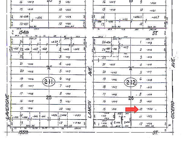
Cicero Ave Sub/A T Mcintosh
28-16-212-022-0000
Cook
Vacantlandnec
Illinois
X
10
17031C0726J
0.33 AC
2023
Near South Cook
2024
Chicago
824602
DEMOGRAPHICS near 15440 Cicero Ave
1 Mile
3 Mile
5 Mile
2024 Total Population
9,965
83,165
240,594
2029 Population
9,671
81,641
236,136
Pop Growth 2024-2029
(2.95%)
(1.83%)
(1.85%)
Average Age
41
41
41
2024 Total Households
3,970
30,675
90,921
HH Growth 2024-2029
(3.30%)
(2.10%)
(2.14%)
Median Household Inc
$72,909
$67,584
$65,810
Avg Household Size
2.50
2.60
2.60
2024 Avg HH Vehicles
2.00
2.00
2.00
Median Home Value
$205,318
$193,991
$202,779
Median Year Built
1975
1972
1974
Nearby Places
- Restaurants
- Banks
- Shops
- Fitness
- Groceries
PUBLIC TRANSPORTATION
COMMUTER RAIL
Oak Forest Station (Rock Island District Line - Northeast Illinois Regional Commuter Railroad (Metra))
DRIVE
WALK
Distance
Oak Forest Station (Rock Island District Line - Northeast Illinois Regional Commuter Railroad (Metra))
1 min
12 min
0.6 mi
Midlothian Station (Rock Island District Line - Northeast Illinois Regional Commuter Railroad (Metra))
DRIVE
WALK
Distance
Midlothian Station (Rock Island District Line - Northeast Illinois Regional Commuter Railroad (Metra))
4 min
2.4 mi
AIRPORT
Chicago Midway International
DRIVE
WALK
Distance
Chicago Midway International
22 min
13.2 mi
Chicago O'Hare International
DRIVE
WALK
Distance
Chicago O'Hare International
48 min
35.3 mi
Freight Ports
Port Milwaukee
DRIVE
WALK
Distance
Port Milwaukee
129 min
107.0 mi
Nearby Properties
Address
Land Use
TOTAL SIZE
Lot Size
Zoning
Address
Land Use
TOTAL SIZE
Lot Size
Zoning
Address
Land Use
TOTAL SIZE
Lot Size
Zoning
266,729 SF
20.64 AC
Address
Land Use
TOTAL SIZE
Lot Size
Zoning
Address
Land Use
TOTAL SIZE
Lot Size
Zoning
152,306 SF
13.40 AC
Address
Land Use
TOTAL SIZE
Lot Size
Zoning
203,995 SF
20.27 AC
Address
Land Use
TOTAL SIZE
Lot Size
Zoning
185,748 SF
15.30 AC
Address
Land Use
TOTAL SIZE
Lot Size
Zoning
114,484 SF
14.88 AC
Address
Land Use
TOTAL SIZE
Lot Size
Zoning
273,000 SF
20.69 AC
Address
Land Use
TOTAL SIZE
Lot Size
Zoning
67,488 SF
10 AC
Address
Land Use
TOTAL SIZE
Lot Size
Zoning
17.50 AC
Address
Land Use
TOTAL SIZE
Lot Size
Zoning
73,696 SF
6.43 AC
Address
Land Use
TOTAL SIZE
Lot Size
Zoning
1.91 AC
Address
Land Use
TOTAL SIZE
Lot Size
Zoning
73,718 SF
Address
Land Use
TOTAL SIZE
Lot Size
Zoning
0.98 AC
Address
Land Use
TOTAL SIZE
Lot Size
Zoning
132,322 SF
2 AC
Address
Land Use
TOTAL SIZE
Lot Size
Zoning
3.87 AC
Address
Land Use
TOTAL SIZE
Lot Size
Zoning
125,337 SF
11.57 AC
Address
Land Use
TOTAL SIZE
Lot Size
Zoning
72,365 SF
13.04 AC
Address
Land Use
TOTAL SIZE
Lot Size
Zoning
1.38 AC
Address
Land Use
TOTAL SIZE
Lot Size
Zoning
66,004 SF
7.47 AC
Address
Land Use
TOTAL SIZE
Lot Size
Zoning
28,672 SF
4 AC
Address
Land Use
TOTAL SIZE
Lot Size
Zoning
80,161 SF
2.09 AC
Address
Land Use
TOTAL SIZE
Lot Size
Zoning
90,890 SF
2.35 AC
Address
Land Use
TOTAL SIZE
Lot Size
Zoning
15,150 SF
1.64 AC
Address
Land Use
TOTAL SIZE
Lot Size
Zoning
20,579 SF
1.14 AC
Address
Land Use
TOTAL SIZE
Lot Size
Zoning
59,497 SF
5.10 AC
Address
Land Use
TOTAL SIZE
Lot Size
Zoning
47,971 SF
1.97 AC
Address
Land Use
TOTAL SIZE
Lot Size
Zoning
55,000 SF
Address
Land Use
TOTAL SIZE
Lot Size
Zoning
4,260 SF
0.04 AC
R6A
Address
Land Use
TOTAL SIZE
Lot Size
Zoning
342,826 SF
9.29 AC
The World's #1 Commercial Real Estate Marketplace
Connect with us
© 2025 CoStar Group
The information above has been obtained from sources believed reliable. While we do not doubt its accuracy we have not verified it and make no guarantee, warranty or representation about it. It is your responsibility to independently confirm its accuracy and completeness. Any projections, opinions, assumptions, or estimates used are for example only and do not represent the current or future performance of the property. The value of this transaction to you depends on tax and other factors which should be evaluated by your tax, financial, and legal advisors. You and your advisors should conduct a careful, independent investigation of the property to determine to your satisfaction the suitability of the property for your needs.