Property Record
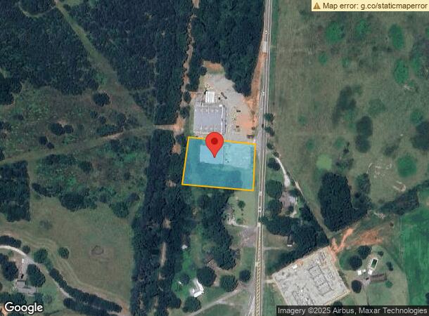
1547 N Cherokee Rd, Social Circle, GA 30025
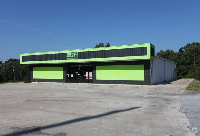
This Property Is For Sale
NEARBY LISTINGS FOR SALE OR LEASE
Property Detail
1547 N Cherokee Rd
Atlanta-Sandy Springs-Roswell, GA
09101-Social Cir Secondary
SC12000000032000
.95AC TR#1
Commercialnec
Walton
X
Georgia
13297C0240F
66
2024
0.95 AC
2025
Walton County
110801
Atlanta
8,000 SF
DEMOGRAPHICS near 1547 N Cherokee Rd
1 Mile
3 Mile
5 Mile
2024 Total Population
384
6,953
11,979
2029 Population
447
8,105
13,944
Pop Growth 2024-2029
+ 16.41%
+ 16.57%
+ 16.40%
Average Age
42
40
41
2024 Total Households
141
2,482
4,270
HH Growth 2024-2029
+ 16.31%
+ 16.84%
+ 16.72%
Median Household Inc
$82,094
$83,987
$83,063
Avg Household Size
2.70
2.80
2.80
2024 Avg HH Vehicles
2.00
2.00
2.00
Median Home Value
$253,636
$259,548
$265,194
Median Year Built
1989
1995
1995
Nearby Places
Map Layers
Map Styles
 Street
 Aerial
- Restaurants
- Banks
- Shops
- Fitness
- Groceries
Nearby Properties
Address
Land Use
TOTAL SIZE
Lot Size
Zoning
Address
Land Use
TOTAL SIZE
Lot Size
Zoning
1,013,621 SF
183.05 AC
LI WP2
Address
Land Use
TOTAL SIZE
Lot Size
Zoning
1,299,643 SF
89.54 AC
LI
Address
Land Use
TOTAL SIZE
Lot Size
Zoning
117,648 SF
27.53 AC
OI
Address
Land Use
TOTAL SIZE
Lot Size
Zoning
2,240 SF
109.79 AC
HI WP2
Address
Land Use
TOTAL SIZE
Lot Size
Zoning
56,497 SF
9.32 AC
OI
Address
Land Use
TOTAL SIZE
Lot Size
Zoning
800 SF
35.79 AC
LI WP2
Address
Land Use
TOTAL SIZE
Lot Size
Zoning
Address
Land Use
TOTAL SIZE
Lot Size
Zoning
2,023 SF
19.54 AC
OI
Address
Land Use
TOTAL SIZE
Lot Size
Zoning
84,000 SF
48.52 AC
MIXED WP2
Address
Land Use
TOTAL SIZE
Lot Size
Zoning
103,180 SF
22.86 AC
LI WP2
Address
Land Use
TOTAL SIZE
Lot Size
Zoning
9,900 SF
8.16 AC
AG WP2
Address
Land Use
TOTAL SIZE
Lot Size
Zoning
7,936 SF
8 AC
LI WP2
Address
Land Use
TOTAL SIZE
Lot Size
Zoning
120,000 SF
14.10 AC
LI WP2
Address
Land Use
TOTAL SIZE
Lot Size
Zoning
96,000 SF
13.40 AC
LI WP2
Address
Land Use
TOTAL SIZE
Lot Size
Zoning
428.84 AC
A1 CITY
Address
Land Use
TOTAL SIZE
Lot Size
Zoning
2,660 SF
23.72 AC
LI WP2
Address
Land Use
TOTAL SIZE
Lot Size
Zoning
10,868 SF
28.61 AC
OI
Address
Land Use
TOTAL SIZE
Lot Size
Zoning
81,250 SF
17 AC
LI WP2
Address
Land Use
TOTAL SIZE
Lot Size
Zoning
38,590 SF
8.54 AC
OI WP2
Address
Land Use
TOTAL SIZE
Lot Size
Zoning
33,012 SF
9.89 AC
GC
Address
Land Use
TOTAL SIZE
Lot Size
Zoning
282.31 AC
A1 WP2
Address
Land Use
TOTAL SIZE
Lot Size
Zoning
31,995 SF
9.05 AC
GC
Address
Land Use
TOTAL SIZE
Lot Size
Zoning
3,392 SF
116.98 AC
AG WP2
Address
Land Use
TOTAL SIZE
Lot Size
Zoning
216.02 AC
A WP2
Address
Land Use
TOTAL SIZE
Lot Size
Zoning
60,000 SF
2.89 AC
LI WP2
Address
Land Use
TOTAL SIZE
Lot Size
Zoning
205 AC
A1
Address
Land Use
TOTAL SIZE
Lot Size
Zoning
8,760 SF
7.49 AC
LI WP2
Address
Land Use
TOTAL SIZE
Lot Size
Zoning
50,000 SF
3.44 AC
LI WP2
Address
Land Use
TOTAL SIZE
Lot Size
Zoning
42,000 SF
17.01 AC
LI WP2
Address
Land Use
TOTAL SIZE
Lot Size
Zoning
157.58 AC
LI WP2
The World's #1 Commercial Real Estate Marketplace
Connect with us
© 2026 CoStar Group
The information above has been obtained from sources believed reliable. While we do not doubt its accuracy we have not verified it and make no guarantee, warranty or representation about it. It is your responsibility to independently confirm its accuracy and completeness. Any projections, opinions, assumptions, or estimates used are for example only and do not represent the current or future performance of the property. The value of this transaction to you depends on tax and other factors which should be evaluated by your tax, financial, and legal advisors. You and your advisors should conduct a careful, independent investigation of the property to determine to your satisfaction the suitability of the property for your needs.