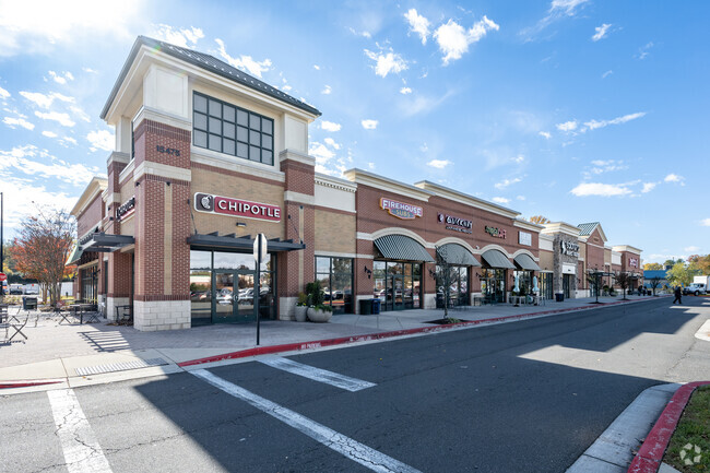
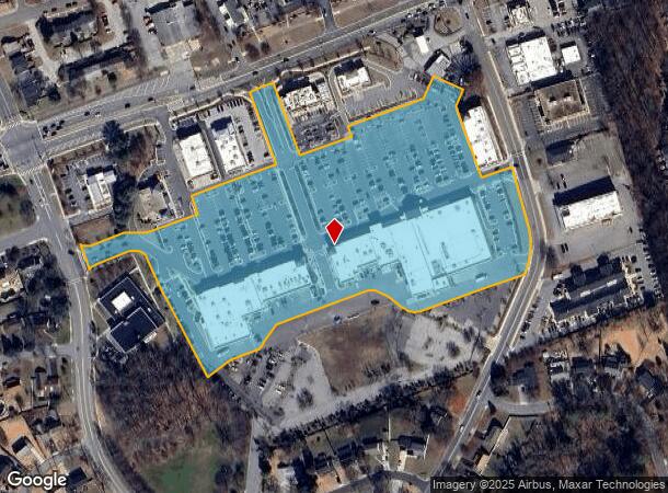
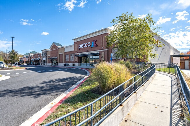
Property Record
15485 Annapolis Rd, Bowie, MD 20715
NEARBY LISTINGS FOR SALE OR LEASE
Property Detail
15485 Annapolis Rd
07-5566826
Be Bowie Landf Condominium
Storebuilding
PARCEL X-13
X
Prince George's
24033C0180E
Maryland
2024
11.17 AC
2025
Bowie
800504
Washington, DC
101,475 SF
Washington-Arlington-Alexandria, DC-VA-MD-WV
DEMOGRAPHICS near 15485 Annapolis Rd
1 Mile
3 Mile
5 Mile
2024 Total Population
9,067
54,037
121,141
2029 Population
8,803
52,738
119,946
Pop Growth 2024-2029
(2.91%)
(2.40%)
(0.99%)
Average Age
44
42
41
2024 Total Households
3,294
19,042
42,146
HH Growth 2024-2029
(3.01%)
(2.44%)
(0.90%)
Median Household Inc
$124,948
$129,428
$133,829
Avg Household Size
2.70
2.70
2.80
2024 Avg HH Vehicles
2.00
2.00
2.00
Median Home Value
$367,502
$417,660
$447,487
Median Year Built
1964
1981
1987
Nearby Places
Map Layers
Map Styles
 Street
 Aerial
- Restaurants
- Banks
- Shops
- Fitness
- Groceries
PUBLIC TRANSPORTATION
COMMUTER RAIL
Bowie State Marc Sb (PENN - WASHINGTON - Maryland Transit Administration)
DRIVE
WALK
Distance
Bowie State Marc Sb (PENN - WASHINGTON - Maryland Transit Administration)
10 min
4.9 mi
Bowie State Marc Nb (PENN - WASHINGTON - Maryland Transit Administration)
DRIVE
WALK
Distance
Bowie State Marc Nb (PENN - WASHINGTON - Maryland Transit Administration)
10 min
4.9 mi
AIRPORT
Baltimore/Washington International Thurgood Marshall
DRIVE
WALK
Distance
Baltimore/Washington International Thurgood Marshall
32 min
20.9 mi
Ronald Reagan Washington Ntl
DRIVE
WALK
Distance
Ronald Reagan Washington Ntl
37 min
23.7 mi
Freight Ports
Port of Baltimore
DRIVE
WALK
Distance
Port of Baltimore
40 min
26.4 mi
SALE & LEASE HISTORY
LISTING DATE
SALE/LEASE

Sep 25, 2016
For Lease
Nearby Properties
Address
Land Use
TOTAL SIZE
Lot Size
Zoning
Address
Land Use
TOTAL SIZE
Lot Size
Zoning
278,982 SF
22.25 AC
LCD
Address
Land Use
TOTAL SIZE
Lot Size
Zoning
6.34 AC
TACE
Address
Land Use
TOTAL SIZE
Lot Size
Zoning
15.34 AC
LCD
Address
Land Use
TOTAL SIZE
Lot Size
Zoning
286 SF
13.08 AC
RMF20
Address
Land Use
TOTAL SIZE
Lot Size
Zoning
338 SF
20.94 AC
RMF20
Address
Land Use
TOTAL SIZE
Lot Size
Zoning
80,321 SF
11.78 AC
CGO
Address
Land Use
TOTAL SIZE
Lot Size
Zoning
287,439 SF
19.97 AC
CGO
Address
Land Use
TOTAL SIZE
Lot Size
Zoning
120,560 SF
9 AC
TACE
Address
Land Use
TOTAL SIZE
Lot Size
Zoning
283,176 SF
30.51 AC
TACC
Address
Land Use
TOTAL SIZE
Lot Size
Zoning
159,944 SF
5.34 AC
C1
Address
Land Use
TOTAL SIZE
Lot Size
Zoning
79,939 SF
6.17 AC
LCD
Address
Land Use
TOTAL SIZE
Lot Size
Zoning
166,720 SF
8.72 AC
TACE
Address
Land Use
TOTAL SIZE
Lot Size
Zoning
122,290 SF
3.14 AC
TACE
Address
Land Use
TOTAL SIZE
Lot Size
Zoning
170,641 SF
4.30 AC
IE
Address
Land Use
TOTAL SIZE
Lot Size
Zoning
124,313 SF
12.70 AC
CGO
Address
Land Use
TOTAL SIZE
Lot Size
Zoning
111,009 SF
11.43 AC
CGO
Address
Land Use
TOTAL SIZE
Lot Size
Zoning
140 SF
5.47 AC
RMF20
Address
Land Use
TOTAL SIZE
Lot Size
Zoning
114,327 SF
14.44 AC
TACE
Address
Land Use
TOTAL SIZE
Lot Size
Zoning
124,984 SF
10.30 AC
TACE
Address
Land Use
TOTAL SIZE
Lot Size
Zoning
102,545 SF
10.79 AC
CGO
Address
Land Use
TOTAL SIZE
Lot Size
Zoning
90,180 SF
6.48 AC
TACE
Address
Land Use
TOTAL SIZE
Lot Size
Zoning
47,132 SF
3.53 AC
LMXC
Address
Land Use
TOTAL SIZE
Lot Size
Zoning
117,622 SF
10.93 AC
CS
Address
Land Use
TOTAL SIZE
Lot Size
Zoning
65,928 SF
6.61 AC
TACC
Address
Land Use
TOTAL SIZE
Lot Size
Zoning
175,036 SF
9.44 AC
TACE
Address
Land Use
TOTAL SIZE
Lot Size
Zoning
159,876 SF
13.62 AC
TACC
Address
Land Use
TOTAL SIZE
Lot Size
Zoning
102,755 SF
7.61 AC
TACE
Address
Land Use
TOTAL SIZE
Lot Size
Zoning
60,600 SF
6 AC
RR
Address
Land Use
TOTAL SIZE
Lot Size
Zoning
129,800 SF
3.13 AC
TACE
The World's #1 Commercial Real Estate Marketplace
Connect with us
© 2026 CoStar Group
The information above has been obtained from sources believed reliable. While we do not doubt its accuracy we have not verified it and make no guarantee, warranty or representation about it. It is your responsibility to independently confirm its accuracy and completeness. Any projections, opinions, assumptions, or estimates used are for example only and do not represent the current or future performance of the property. The value of this transaction to you depends on tax and other factors which should be evaluated by your tax, financial, and legal advisors. You and your advisors should conduct a careful, independent investigation of the property to determine to your satisfaction the suitability of the property for your needs.