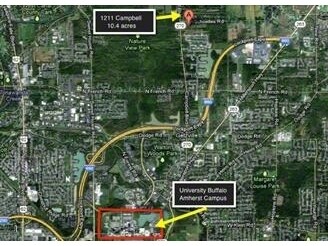
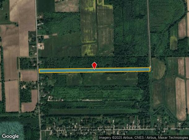
Property Record
1549 Campbell Blvd, Buffalo, NY 14228
NEARBY LISTINGS FOR SALE OR LEASE
Property Detail
1549 Campbell Blvd
Buffalo-Cheektowaga-Niagara Falls, NY
UTIL VAC ROW LAND LOCATION 1712285 TAPS 36 & 37
142289-015-000-0002-021-200
Erie
Governmentvacantland
New York
AE
21.200
36029C0067H
11.78 AC
2025
North
2024
Buffalo/Niagara Falls
009009
DEMOGRAPHICS near 1549 Campbell Blvd
1 Mile
3 Mile
5 Mile
2024 Total Population
1,174
26,142
103,764
2029 Population
1,112
25,775
103,314
Pop Growth 2024-2029
(5.28%)
(1.40%)
(0.43%)
Average Age
41
41
41
2024 Total Households
469
10,375
39,752
HH Growth 2024-2029
(5.33%)
(1.45%)
(0.37%)
Median Household Inc
$145,762
$92,864
$85,937
Avg Household Size
2.50
2.40
2.40
2024 Avg HH Vehicles
2.00
2.00
2.00
Median Home Value
$550,830
$290,165
$268,831
Median Year Built
2001
1981
1979
Nearby Places
- Restaurants
- Banks
- Shops
- Fitness
- Groceries
PUBLIC TRANSPORTATION
AIRPORT
Buffalo Niagara International
DRIVE
WALK
Distance
Buffalo Niagara International
29 min
12.1 mi
Niagara Falls International
DRIVE
WALK
Distance
Niagara Falls International
28 min
13.0 mi
Freight Ports
Albany, NY Port
DRIVE
WALK
Distance
Albany, NY Port
350 min
293.3 mi
SALE & LEASE HISTORY
LISTING DATE
SALE/LEASE

Sep 24, 2016
For Sale
Nearby Properties
Address
Land Use
TOTAL SIZE
Lot Size
Zoning
Address
Land Use
TOTAL SIZE
Lot Size
Zoning
5,472 SF
70.10 AC
Address
Land Use
TOTAL SIZE
Lot Size
Zoning
2,592 SF
22.75 AC
NCD
Address
Land Use
TOTAL SIZE
Lot Size
Zoning
5,364 SF
56.45 AC
Address
Land Use
TOTAL SIZE
Lot Size
Zoning
213,943 SF
5.50 AC
Address
Land Use
TOTAL SIZE
Lot Size
Zoning
403,248 SF
53.50 AC
Address
Land Use
TOTAL SIZE
Lot Size
Zoning
253,920 SF
22.83 AC
RD
Address
Land Use
TOTAL SIZE
Lot Size
Zoning
11,248 SF
21.70 AC
MFR-5
Address
Land Use
TOTAL SIZE
Lot Size
Zoning
154,296 SF
7.90 AC
RD
Address
Land Use
TOTAL SIZE
Lot Size
Zoning
28,530 SF
30.20 AC
NCD
Address
Land Use
TOTAL SIZE
Lot Size
Zoning
12,132 SF
12.30 AC
Address
Land Use
TOTAL SIZE
Lot Size
Zoning
87,718 SF
1.26 AC
RD
Address
Land Use
TOTAL SIZE
Lot Size
Zoning
9,338 SF
6.20 AC
Address
Land Use
TOTAL SIZE
Lot Size
Zoning
128,867 SF
9.42 AC
RD
Address
Land Use
TOTAL SIZE
Lot Size
Zoning
106,676 SF
8.90 AC
RD
Address
Land Use
TOTAL SIZE
Lot Size
Zoning
131,200 SF
16.90 AC
Address
Land Use
TOTAL SIZE
Lot Size
Zoning
39,454 SF
4.81 AC
GC
Address
Land Use
TOTAL SIZE
Lot Size
Zoning
131,128 SF
15.48 AC
RD
Address
Land Use
TOTAL SIZE
Lot Size
Zoning
92,368 SF
0.75 AC
RD
Address
Land Use
TOTAL SIZE
Lot Size
Zoning
63,464 SF
2.44 AC
Address
Land Use
TOTAL SIZE
Lot Size
Zoning
86,640 SF
10.30 AC
RD
Address
Land Use
TOTAL SIZE
Lot Size
Zoning
97,580 SF
8.43 AC
Address
Land Use
TOTAL SIZE
Lot Size
Zoning
91,035 SF
20.40 AC
Address
Land Use
TOTAL SIZE
Lot Size
Zoning
32,856 SF
4.88 AC
Address
Land Use
TOTAL SIZE
Lot Size
Zoning
44,085 SF
7.34 AC
RD
Address
Land Use
TOTAL SIZE
Lot Size
Zoning
49,486 SF
4.20 AC
Address
Land Use
TOTAL SIZE
Lot Size
Zoning
98,114 SF
7 AC
Address
Land Use
TOTAL SIZE
Lot Size
Zoning
114 AC
NCD
Address
Land Use
TOTAL SIZE
Lot Size
Zoning
67,285 SF
6.73 AC
RD
Address
Land Use
TOTAL SIZE
Lot Size
Zoning
60.20 AC
NCD
Address
Land Use
TOTAL SIZE
Lot Size
Zoning
38,824 SF
2.53 AC
NB
The World's #1 Commercial Real Estate Marketplace
Connect with us
© 2025 CoStar Group
The information above has been obtained from sources believed reliable. While we do not doubt its accuracy we have not verified it and make no guarantee, warranty or representation about it. It is your responsibility to independently confirm its accuracy and completeness. Any projections, opinions, assumptions, or estimates used are for example only and do not represent the current or future performance of the property. The value of this transaction to you depends on tax and other factors which should be evaluated by your tax, financial, and legal advisors. You and your advisors should conduct a careful, independent investigation of the property to determine to your satisfaction the suitability of the property for your needs.