Property Record
155 Constitution Way, North Salt Lake, UT 84054
This Property Is For Sale
NEARBY LISTINGS FOR SALE OR LEASE
Property Detail
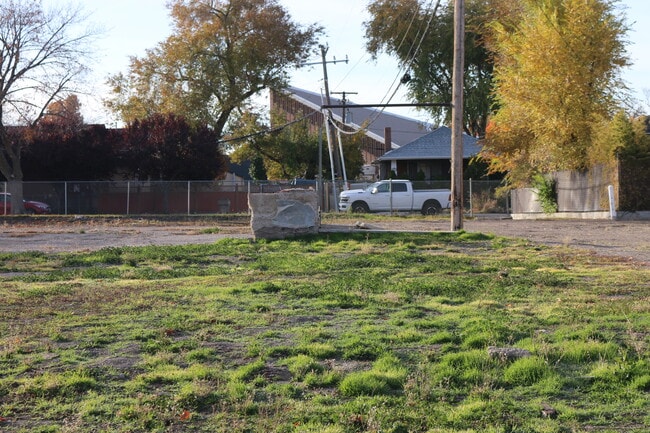
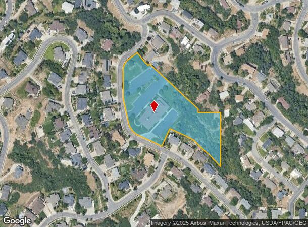
155 Constitution Way
01-142-0018
Hillside Oaks Sub
Religious
Davis
X
Utah
49035C0150G
1,30
0
4.20 AC
2025
Davis/Weber Counties
127002
Salt Lake City
16,863 SF
Ogden-Clearfield, UT
DEMOGRAPHICS near 155 Constitution Way
1 Mile
3 Mile
5 Mile
2024 Total Population
13,837
54,474
148,279
2029 Population
14,246
55,991
152,575
Pop Growth 2024-2029
+ 2.96%
+ 2.78%
+ 2.90%
Average Age
37
36
37
2024 Total Households
4,563
17,804
55,136
HH Growth 2024-2029
+ 3.18%
+ 2.96%
+ 3.35%
Median Household Inc
$126,486
$110,011
$94,255
Avg Household Size
3.00
3.00
2.60
2024 Avg HH Vehicles
2.00
2.00
2.00
Median Home Value
$658,852
$556,949
$555,800
Median Year Built
1994
1990
1978
Nearby Places
- Restaurants
- Banks
- Shops
- Fitness
- Groceries
PUBLIC TRANSPORTATION
COMMUTER RAIL
Woods Cross (FrontRunner North - Utah Transit Authority (UTA))
DRIVE
WALK
Distance
Woods Cross (FrontRunner North - Utah Transit Authority (UTA))
11 min
4.4 mi
Warm Springs Relief Point (FrontRunner - Utah Transit Authority (UTA))
DRIVE
WALK
Distance
Warm Springs Relief Point (FrontRunner - Utah Transit Authority (UTA))
12 min
5.4 mi
AIRPORT
Salt Lake City International
DRIVE
WALK
Distance
Salt Lake City International
18 min
11.6 mi
Freight Ports
Port of Stockton
DRIVE
WALK
Distance
Port of Stockton
719 min
702.0 mi
Nearby Properties
Address
Land Use
TOTAL SIZE
Lot Size
Zoning
Address
Land Use
TOTAL SIZE
Lot Size
Zoning
6,673 SF
345.82 AC
Address
Land Use
TOTAL SIZE
Lot Size
Zoning
167,620 SF
114.91 AC
M-1
Address
Land Use
TOTAL SIZE
Lot Size
Zoning
63,793 SF
113.37 AC
M-2
Address
Land Use
TOTAL SIZE
Lot Size
Zoning
132.55 AC
6192
Address
Land Use
TOTAL SIZE
Lot Size
Zoning
240,104 SF
37.03 AC
C2
Address
Land Use
TOTAL SIZE
Lot Size
Zoning
657,526 SF
35.95 AC
MD
Address
Land Use
TOTAL SIZE
Lot Size
Zoning
4,241 SF
8.67 AC
P
Address
Land Use
TOTAL SIZE
Lot Size
Zoning
208,638 SF
56.05 AC
Address
Land Use
TOTAL SIZE
Lot Size
Zoning
3,026 SF
14.42 AC
P
Address
Land Use
TOTAL SIZE
Lot Size
Zoning
13,126 SF
7.83 AC
P
Address
Land Use
TOTAL SIZE
Lot Size
Zoning
113,265 SF
0.55 AC
CG
Address
Land Use
TOTAL SIZE
Lot Size
Zoning
230,020 SF
27.33 AC
MD
Address
Land Use
TOTAL SIZE
Lot Size
Zoning
259,942 SF
18.52 AC
MD
Address
Land Use
TOTAL SIZE
Lot Size
Zoning
155,896 SF
8.96 AC
Address
Land Use
TOTAL SIZE
Lot Size
Zoning
58,273 SF
3.80 AC
I1
Address
Land Use
TOTAL SIZE
Lot Size
Zoning
19,299 SF
3.06 AC
Address
Land Use
TOTAL SIZE
Lot Size
Zoning
113,197 SF
3.62 AC
Address
Land Use
TOTAL SIZE
Lot Size
Zoning
119,710 SF
13.15 AC
R4
Address
Land Use
TOTAL SIZE
Lot Size
Zoning
6,050 SF
59.94 AC
Address
Land Use
TOTAL SIZE
Lot Size
Zoning
103,724 SF
8.40 AC
M-1
Address
Land Use
TOTAL SIZE
Lot Size
Zoning
101,110 SF
8.12 AC
Address
Land Use
TOTAL SIZE
Lot Size
Zoning
57,830 SF
3.54 AC
Address
Land Use
TOTAL SIZE
Lot Size
Zoning
54 AC
1107
Address
Land Use
TOTAL SIZE
Lot Size
Zoning
9,747 SF
7.73 AC
R4
Address
Land Use
TOTAL SIZE
Lot Size
Zoning
166.84 AC
R-F
Address
Land Use
TOTAL SIZE
Lot Size
Zoning
72,760 SF
12 AC
PD
Address
Land Use
TOTAL SIZE
Lot Size
Zoning
13,269 SF
9.45 AC
PD
Address
Land Use
TOTAL SIZE
Lot Size
Zoning
22,344 SF
5.12 AC
Address
Land Use
TOTAL SIZE
Lot Size
Zoning
30,937 SF
30.71 AC
MG
Address
Land Use
TOTAL SIZE
Lot Size
Zoning
15,156 SF
62.71 AC
M1
The World's #1 Commercial Real Estate Marketplace
Connect with us
© 2025 CoStar Group
The information above has been obtained from sources believed reliable. While we do not doubt its accuracy we have not verified it and make no guarantee, warranty or representation about it. It is your responsibility to independently confirm its accuracy and completeness. Any projections, opinions, assumptions, or estimates used are for example only and do not represent the current or future performance of the property. The value of this transaction to you depends on tax and other factors which should be evaluated by your tax, financial, and legal advisors. You and your advisors should conduct a careful, independent investigation of the property to determine to your satisfaction the suitability of the property for your needs.