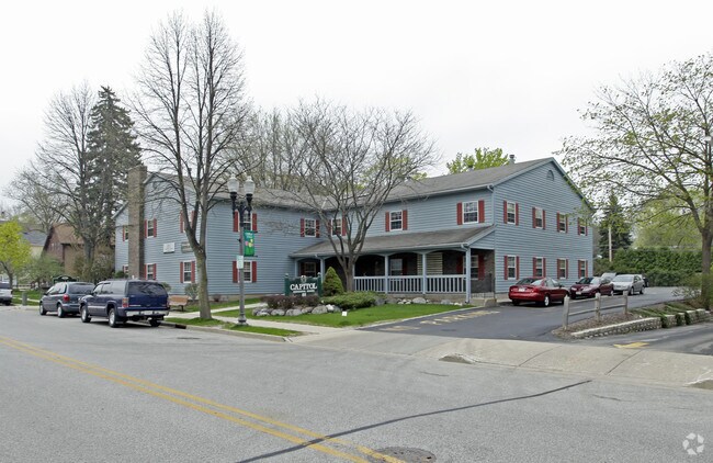
Property Record
155 E Capitol Dr, Hartland, WI 53029


Save to a Folder
{{folder.Name}}
{{folder.ListingIds.length}} Properties
{{folder.ListingIds.length}} Property
Create a New Folder
Property Detail
155 E Capitol Dr
Milwaukee-Waukesha, WI
LOT 37 ASSESSORS PLAT NO 1 PT NE1/4 SEC 3 T7N R18E :: DOC# 3196345 & DOC# 4290890
HAV-0729-012
Waukesha
Commercialnec
Wisconsin
B and X Area of moderate flood hazard, usually the area between the limits of the 100-year and 500-year floods.
37
2025
0.51 AC
2025
NE/Delafield
203602
Milwaukee/Madison
NEARBY LISTINGS FOR SALE OR LEASE
DEMOGRAPHICS near 155 E Capitol Dr
1 mile
3 mile
5 mile
2025 Total Population
6,680
20,737
52,586
2030 Population
6,850
21,214
53,783
Pop Growth 2025-2030
+ 2.54%
+ 2.30%
+ 2.28%
Average Age
42
43
44
2025 Total Households
2,930
8,131
20,978
HH Growth 2025-2030
+ 2.63%
+ 2.44%
+ 2.34%
Median Household Inc
$73,704
$110,785
$112,970
Avg Household Size
2.20
2.50
2.50
2025 Avg HH Vehicles
2.00
2.00
2.00
Median Home Value
$364,353
$505,343
$484,925
Median Year Built
1982
1987
1987
Nearby Places
Map Layers
Map Styles
 Street
 Aerial
Layers
 Traffic
 Biking
Places
Listings with unknown addresses are not visible on the map
- Restaurants
- Banks
- Shops
- Fitness
- Groceries
PUBLIC TRANSPORTATION
AIRPORT
General Mitchell International
Drive
Walk
Distance
General Mitchell International
45 min
31.6 mi
Freight Ports
Port Milwaukee
Drive
Walk
Distance
Port Milwaukee
38 min
28.1 mi
SALE & LEASE HISTORY
LISTING DATE
SALE/LEASE

Sep 25, 2016
For Lease
May 15, 2019
For Lease
Nearby Properties
Address
Land Use
TOTAL SIZE
Lot Size
Zoning
Address
Land Use
TOTAL SIZE
Lot Size
Zoning
13.52 AC
Address
Land Use
TOTAL SIZE
Lot Size
Zoning
Address
Land Use
TOTAL SIZE
Lot Size
Zoning
Address
Land Use
TOTAL SIZE
Lot Size
Zoning
23.05 AC
Address
Land Use
TOTAL SIZE
Lot Size
Zoning
2.06 AC
Address
Land Use
TOTAL SIZE
Lot Size
Zoning
16.23 AC
Address
Land Use
TOTAL SIZE
Lot Size
Zoning
13.48 AC
Address
Land Use
TOTAL SIZE
Lot Size
Zoning
14.19 AC
Address
Land Use
TOTAL SIZE
Lot Size
Zoning
Address
Land Use
TOTAL SIZE
Lot Size
Zoning
Address
Land Use
TOTAL SIZE
Lot Size
Zoning
3.79 AC
Address
Land Use
TOTAL SIZE
Lot Size
Zoning
12.11 AC
Address
Land Use
TOTAL SIZE
Lot Size
Zoning
2.83 AC
Address
Land Use
TOTAL SIZE
Lot Size
Zoning
18.15 AC
Address
Land Use
TOTAL SIZE
Lot Size
Zoning
40.01 AC
Address
Land Use
TOTAL SIZE
Lot Size
Zoning
11.21 AC
Address
Land Use
TOTAL SIZE
Lot Size
Zoning
Address
Land Use
TOTAL SIZE
Lot Size
Zoning
Address
Land Use
TOTAL SIZE
Lot Size
Zoning
Address
Land Use
TOTAL SIZE
Lot Size
Zoning
7.35 AC
Address
Land Use
TOTAL SIZE
Lot Size
Zoning
195.92 AC
Address
Land Use
TOTAL SIZE
Lot Size
Zoning
Address
Land Use
TOTAL SIZE
Lot Size
Zoning
Address
Land Use
TOTAL SIZE
Lot Size
Zoning
3.87 AC
Address
Land Use
TOTAL SIZE
Lot Size
Zoning
Address
Land Use
TOTAL SIZE
Lot Size
Zoning
Address
Land Use
TOTAL SIZE
Lot Size
Zoning
5.22 AC
Address
Land Use
TOTAL SIZE
Lot Size
Zoning
Address
Land Use
TOTAL SIZE
Lot Size
Zoning
3.59 AC
Address
Land Use
TOTAL SIZE
Lot Size
Zoning
The World's #1 Commercial Real Estate Marketplace
Connect with us
© 2026 CoStar Group
The information above has been obtained from sources believed reliable. While we do not doubt its accuracy we have not verified it and make no guarantee, warranty or representation about it. It is your responsibility to independently confirm its accuracy and completeness. Any projections, opinions, assumptions, or estimates used are for example only and do not represent the current or future performance of the property. The value of this transaction to you depends on tax and other factors which should be evaluated by your tax, financial, and legal advisors. You and your advisors should conduct a careful, independent investigation of the property to determine to your satisfaction the suitability of the property for your needs.