Property Record
155 E Main St, Newark, DE 19711
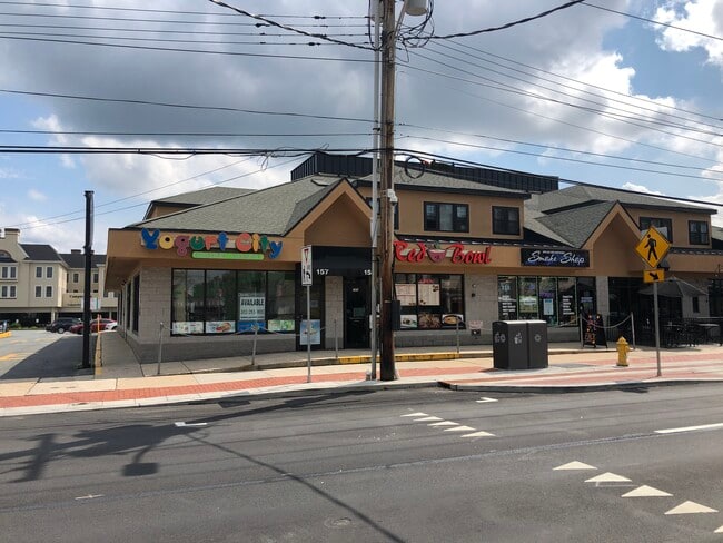

Property Detail
155 E Main St
18-020.00-187
NEW CASTLE
Apartment
Delaware
18BB
a
B and X Area of moderate flood hazard, usually the area between the limits of the 100-year and 500-year floods.
0.88 AC
2024
South New Castle County
2024
Philadelphia
013610
Philadelphia-Camden-Wilmington, PA-NJ-DE-MD
22,029 SF
NEARBY LISTINGS FOR SALE OR LEASE
DEMOGRAPHICS near 155 E Main St
1 mile
3 mile
5 mile
2025 Total Population
23,795
70,796
149,088
2030 Population
26,041
74,551
154,349
Pop Growth 2025-2030
+ 9.44%
+ 5.30%
+ 3.53%
Average Age
28
36
39
2025 Total Households
6,474
25,121
56,454
HH Growth 2025-2030
+ 12.02%
+ 5.66%
+ 3.63%
Median Household Inc
$52,894
$75,114
$84,575
Avg Household Size
2.50
2.50
2.40
2025 Avg HH Vehicles
2.00
2.00
2.00
Median Home Value
$396,423
$347,110
$342,176
Median Year Built
1995
1975
1981
Nearby Places
Map Layers
Map Styles
 Street
 Aerial
Transit
 Traffic
 Biking
Places
Listings with unknown addresses are not visible on the map
- Restaurants
- Banks
- Shops
- Fitness
- Groceries
PUBLIC TRANSPORTATION
COMMUTER RAIL
Newark (R2 - Southeastern Pennsylvania Transportation Authority Regional Rail (SEPTA Regional Rail))
Drive
Walk
Distance
Newark (R2 - Southeastern Pennsylvania Transportation Authority Regional Rail (SEPTA Regional Rail))
3 min
1.3 mi
Churchmans Crossing (R2 - Southeastern Pennsylvania Transportation Authority Regional Rail (SEPTA Regional Rail))
Drive
Walk
Distance
Churchmans Crossing (R2 - Southeastern Pennsylvania Transportation Authority Regional Rail (SEPTA Regional Rail))
11 min
5.6 mi
AIRPORT
Philadelphia International
Drive
Walk
Distance
Philadelphia International
48 min
34.4 mi
Freight Ports
Port of Wilmington, RI
Drive
Walk
Distance
Port of Wilmington, RI
23 min
14.3 mi
SALE & LEASE HISTORY
LISTING DATE
SALE/LEASE

Sep 24, 2025
For Lease
Sep 24, 2025
For Sale
Aug 20, 2020
For Lease
Nearby Properties
Address
Land Use
TOTAL SIZE
Lot Size
Zoning
Address
Land Use
TOTAL SIZE
Lot Size
Zoning
354.61 AC
18UN
Address
Land Use
TOTAL SIZE
Lot Size
Zoning
108,170 SF
111.08 AC
18UN
Address
Land Use
TOTAL SIZE
Lot Size
Zoning
186,700 SF
5.50 AC
18UN
Address
Land Use
TOTAL SIZE
Lot Size
Zoning
383,319 SF
234.70 AC
I
Address
Land Use
TOTAL SIZE
Lot Size
Zoning
119,820 SF
19.86 AC
18UN
Address
Land Use
TOTAL SIZE
Lot Size
Zoning
169,544 SF
60.86 AC
OR
Address
Land Use
TOTAL SIZE
Lot Size
Zoning
92,081 SF
30.99 AC
18RM
Address
Land Use
TOTAL SIZE
Lot Size
Zoning
4,520 SF
3.51 AC
18UN
Address
Land Use
TOTAL SIZE
Lot Size
Zoning
Address
Land Use
TOTAL SIZE
Lot Size
Zoning
138,791 SF
15.19 AC
18STC
Address
Land Use
TOTAL SIZE
Lot Size
Zoning
48,833 SF
33.06 AC
OR
Address
Land Use
TOTAL SIZE
Lot Size
Zoning
Address
Land Use
TOTAL SIZE
Lot Size
Zoning
247,122 SF
30.25 AC
S
Address
Land Use
TOTAL SIZE
Lot Size
Zoning
3,150 SF
11.90 AC
NC6.5
Address
Land Use
TOTAL SIZE
Lot Size
Zoning
43,943 SF
8.95 AC
18BB
Address
Land Use
TOTAL SIZE
Lot Size
Zoning
4.57 AC
18UN
Address
Land Use
TOTAL SIZE
Lot Size
Zoning
80,834 SF
4.60 AC
18BB
Address
Land Use
TOTAL SIZE
Lot Size
Zoning
7,146 SF
20 AC
S
Address
Land Use
TOTAL SIZE
Lot Size
Zoning
2,400 SF
9.18 AC
18UN
Address
Land Use
TOTAL SIZE
Lot Size
Zoning
54,907 SF
21.74 AC
18RA
Address
Land Use
TOTAL SIZE
Lot Size
Zoning
2,463 SF
5.98 AC
18STC
Address
Land Use
TOTAL SIZE
Lot Size
Zoning
117,727 SF
19.17 AC
NCAP
Address
Land Use
TOTAL SIZE
Lot Size
Zoning
150,729 SF
1.60 AC
CR
Address
Land Use
TOTAL SIZE
Lot Size
Zoning
15,374 SF
15.37 AC
18RH
Address
Land Use
TOTAL SIZE
Lot Size
Zoning
114,831 SF
6.87 AC
NC21
Address
Land Use
TOTAL SIZE
Lot Size
Zoning
128,256 SF
4.71 AC
18BC
Address
Land Use
TOTAL SIZE
Lot Size
Zoning
57,214 SF
1.10 AC
18BB
Address
Land Use
TOTAL SIZE
Lot Size
Zoning
306,266 SF
4.65 AC
CR
Address
Land Use
TOTAL SIZE
Lot Size
Zoning
157,120 SF
13.22 AC
OR
Address
Land Use
TOTAL SIZE
Lot Size
Zoning
121,172 SF
4.22 AC
18STC
The World's #1 Commercial Real Estate Marketplace
Connect with us
© 2026 CoStar Group
The information above has been obtained from sources believed reliable. While we do not doubt its accuracy we have not verified it and make no guarantee, warranty or representation about it. It is your responsibility to independently confirm its accuracy and completeness. Any projections, opinions, assumptions, or estimates used are for example only and do not represent the current or future performance of the property. The value of this transaction to you depends on tax and other factors which should be evaluated by your tax, financial, and legal advisors. You and your advisors should conduct a careful, independent investigation of the property to determine to your satisfaction the suitability of the property for your needs.