Property Record
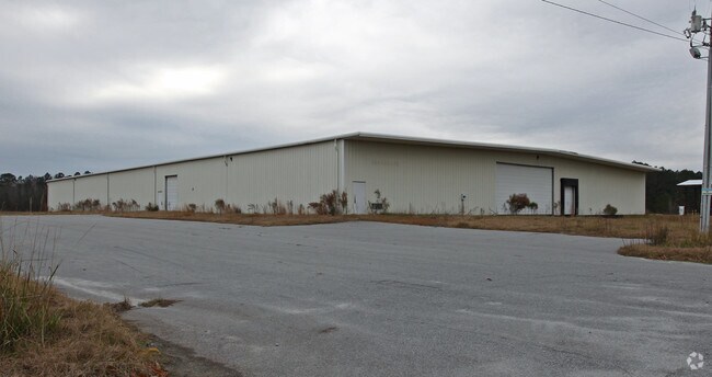
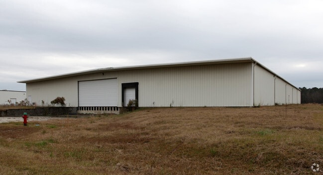
155 Elliot Dixon Dr, Ayden, NC 28513

Property Detail
155 Elliot Dixon Dr
049551
SOUTH PITT INDUSTRIAL PAR
Warehouse
PITT
LI
North Carolina
B and X Area of moderate flood hazard, usually the area between the limits of the 100-year and 500-year floods.
6
2025
2.76 AC
2025
North Carolina Northeast Area
001404
Other Market Areas
37,950 SF
Greenville, NC
NEARBY LISTINGS FOR SALE OR LEASE
-
-
View all Ayden listings for sale on LoopNet.com
DEMOGRAPHICS near 155 Elliot Dixon Dr
1 mile
3 mile
5 mile
2025 Total Population
1,051
8,106
14,356
2030 Population
1,116
8,483
14,894
Pop Growth 2025-2030
+ 6.18%
+ 4.65%
+ 3.75%
Average Age
44
42
42
2025 Total Households
408
3,346
5,783
HH Growth 2025-2030
+ 5.88%
+ 4.51%
+ 3.72%
Median Household Inc
$44,749
$52,893
$60,477
Avg Household Size
2.30
2.30
2.40
2025 Avg HH Vehicles
2.00
2.00
2.00
Median Home Value
$139,899
$158,752
$181,224
Median Year Built
1989
1988
1991
Nearby Places
Map Layers
Map Styles
 Street
 Aerial
Layers
 Traffic
 Biking
Places
Listings with unknown addresses are not visible on the map
- Restaurants
- Banks
- Shops
- Fitness
- Groceries
PUBLIC TRANSPORTATION
AIRPORT
Pitt-Greenville
Drive
Walk
Distance
Pitt-Greenville
26 min
19.4 mi
Freight Ports
Port of Morehead City
Drive
Walk
Distance
Port of Morehead City
127 min
82.7 mi
Nearby Properties
Address
Land Use
TOTAL SIZE
Lot Size
Zoning
Address
Land Use
TOTAL SIZE
Lot Size
Zoning
207,020 SF
32.62 AC
LI
Address
Land Use
TOTAL SIZE
Lot Size
Zoning
9,169 SF
13.45 AC
MF
Address
Land Use
TOTAL SIZE
Lot Size
Zoning
365,756 SF
180.61 AC
I
Address
Land Use
TOTAL SIZE
Lot Size
Zoning
121,344 SF
12.80 AC
LI
Address
Land Use
TOTAL SIZE
Lot Size
Zoning
96,731 SF
16.10 AC
R8
Address
Land Use
TOTAL SIZE
Lot Size
Zoning
150,064 SF
27.27 AC
B1
Address
Land Use
TOTAL SIZE
Lot Size
Zoning
206,168 SF
20 AC
LI
Address
Land Use
TOTAL SIZE
Lot Size
Zoning
50,441 SF
5.44 AC
B2
Address
Land Use
TOTAL SIZE
Lot Size
Zoning
64,906 SF
31.48 AC
R10
Address
Land Use
TOTAL SIZE
Lot Size
Zoning
34,564 SF
11.40 AC
R8
Address
Land Use
TOTAL SIZE
Lot Size
Zoning
1,941 SF
17.60 AC
MF
Address
Land Use
TOTAL SIZE
Lot Size
Zoning
108.24 AC
RA20
Address
Land Use
TOTAL SIZE
Lot Size
Zoning
288 SF
9.16 AC
MF
Address
Land Use
TOTAL SIZE
Lot Size
Zoning
14,864 SF
3.26 AC
B2
Address
Land Use
TOTAL SIZE
Lot Size
Zoning
37,312 SF
3.83 AC
B2
Address
Land Use
TOTAL SIZE
Lot Size
Zoning
12,930 SF
49.63 AC
LI
Address
Land Use
TOTAL SIZE
Lot Size
Zoning
11,200 SF
1.80 AC
B2
Address
Land Use
TOTAL SIZE
Lot Size
Zoning
3,540 SF
7.27 AC
R8
Address
Land Use
TOTAL SIZE
Lot Size
Zoning
7,180 SF
4.14 AC
B2
Address
Land Use
TOTAL SIZE
Lot Size
Zoning
44,015 SF
4.59 AC
B2
Address
Land Use
TOTAL SIZE
Lot Size
Zoning
14,929 SF
5.48 AC
LI
Address
Land Use
TOTAL SIZE
Lot Size
Zoning
17,584 SF
0.70 AC
B1
Address
Land Use
TOTAL SIZE
Lot Size
Zoning
53.33 AC
RA20
Address
Land Use
TOTAL SIZE
Lot Size
Zoning
6,456 SF
1.50 AC
B2
Address
Land Use
TOTAL SIZE
Lot Size
Zoning
26,580 SF
2.50 AC
R8
Address
Land Use
TOTAL SIZE
Lot Size
Zoning
5,608 SF
1.92 AC
R8
Address
Land Use
TOTAL SIZE
Lot Size
Zoning
13,680 SF
3.19 AC
B2
Address
Land Use
TOTAL SIZE
Lot Size
Zoning
19,800 SF
7.40 AC
LI
Address
Land Use
TOTAL SIZE
Lot Size
Zoning
38,852 SF
145.15 AC
RA20
Address
Land Use
TOTAL SIZE
Lot Size
Zoning
44,934 SF
2.71 AC
CDF
The World's #1 Commercial Real Estate Marketplace
Connect with us
© 2026 CoStar Group
The information above has been obtained from sources believed reliable. While we do not doubt its accuracy we have not verified it and make no guarantee, warranty or representation about it. It is your responsibility to independently confirm its accuracy and completeness. Any projections, opinions, assumptions, or estimates used are for example only and do not represent the current or future performance of the property. The value of this transaction to you depends on tax and other factors which should be evaluated by your tax, financial, and legal advisors. You and your advisors should conduct a careful, independent investigation of the property to determine to your satisfaction the suitability of the property for your needs.