Property Record
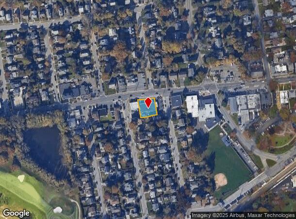
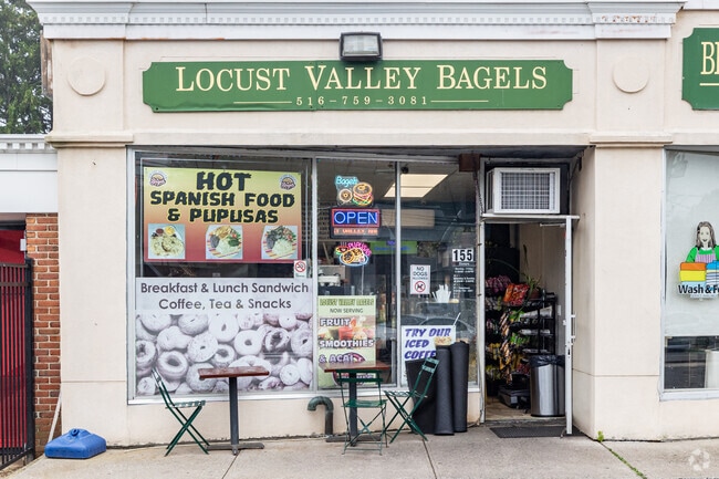
155 Forest Ave, Locust Valley, NY 11560

NEARBY LISTINGS FOR SALE OR LEASE
Property Detail
155 Forest Ave
2489-23-019-00-0113-0
113-116
Commercialnec
Nassau
X
New York
36059C0038G
113-1
2025
0.25 AC
2025
Northern Nassau
517802
Long Island (New York)
7,264 SF
Nassau County-Suffolk County, NY
DEMOGRAPHICS near 155 Forest Ave
1 Mile
3 Mile
5 Mile
2024 Total Population
5,959
47,404
81,667
2029 Population
5,903
47,446
81,551
Pop Growth 2024-2029
(0.94%)
+ 0.09%
(0.14%)
Average Age
43
43
43
2024 Total Households
2,030
16,792
28,818
HH Growth 2024-2029
(1.18%)
+ 0.06%
(0.22%)
Median Household Inc
$132,075
$105,210
$117,277
Avg Household Size
2.80
2.70
2.70
2024 Avg HH Vehicles
2.00
2.00
2.00
Median Home Value
$785,834
$763,476
$811,906
Median Year Built
1958
1957
1958
Nearby Places
- Restaurants
- Banks
- Shops
- Fitness
- Groceries
PUBLIC TRANSPORTATION
COMMUTER RAIL
Locust Valley Station (Oyster Bay Branch - Long Island Rail Road)
DRIVE
WALK
Distance
Locust Valley Station (Oyster Bay Branch - Long Island Rail Road)
0 min
4 min
0.2 mi
Glen Cove Station (Oyster Bay Branch - Long Island Rail Road)
DRIVE
WALK
Distance
Glen Cove Station (Oyster Bay Branch - Long Island Rail Road)
3 min
1.8 mi
AIRPORT
LaGuardia
DRIVE
WALK
Distance
LaGuardia
37 min
23.7 mi
John F Kennedy International
DRIVE
WALK
Distance
John F Kennedy International
39 min
26.5 mi
Westchester County
DRIVE
WALK
Distance
Westchester County
66 min
42.6 mi
Freight Ports
NY - Red Hook Container Terminal
DRIVE
WALK
Distance
NY - Red Hook Container Terminal
48 min
31.8 mi
Nearby Properties
Address
Land Use
TOTAL SIZE
Lot Size
Zoning
Address
Land Use
TOTAL SIZE
Lot Size
Zoning
175,272 SF
209.20 AC
Address
Land Use
TOTAL SIZE
Lot Size
Zoning
5,039 SF
92.07 AC
Address
Land Use
TOTAL SIZE
Lot Size
Zoning
23,629 SF
44.63 AC
Address
Land Use
TOTAL SIZE
Lot Size
Zoning
20,000 SF
58.45 AC
Address
Land Use
TOTAL SIZE
Lot Size
Zoning
105.79 AC
Address
Land Use
TOTAL SIZE
Lot Size
Zoning
8,564 SF
38.71 AC
Address
Land Use
TOTAL SIZE
Lot Size
Zoning
121,473 SF
10.34 AC
Address
Land Use
TOTAL SIZE
Lot Size
Zoning
232,700 SF
42.75 AC
Address
Land Use
TOTAL SIZE
Lot Size
Zoning
3,020 SF
46.45 AC
Address
Land Use
TOTAL SIZE
Lot Size
Zoning
164,742 SF
3.54 AC
Address
Land Use
TOTAL SIZE
Lot Size
Zoning
387,645 SF
7.21 AC
Address
Land Use
TOTAL SIZE
Lot Size
Zoning
237,994 SF
3.98 AC
Address
Land Use
TOTAL SIZE
Lot Size
Zoning
409,120 SF
20.85 AC
Address
Land Use
TOTAL SIZE
Lot Size
Zoning
23,321 SF
43.95 AC
Address
Land Use
TOTAL SIZE
Lot Size
Zoning
195,812 SF
2.30 AC
Address
Land Use
TOTAL SIZE
Lot Size
Zoning
161,595 SF
29.91 AC
Address
Land Use
TOTAL SIZE
Lot Size
Zoning
267,367 SF
23.05 AC
Address
Land Use
TOTAL SIZE
Lot Size
Zoning
3,456 SF
25.52 AC
Address
Land Use
TOTAL SIZE
Lot Size
Zoning
18,626 SF
21.37 AC
Address
Land Use
TOTAL SIZE
Lot Size
Zoning
3,960 SF
39.54 AC
Address
Land Use
TOTAL SIZE
Lot Size
Zoning
6,013 SF
20.57 AC
Address
Land Use
TOTAL SIZE
Lot Size
Zoning
2,103 SF
20.11 AC
Address
Land Use
TOTAL SIZE
Lot Size
Zoning
18.03 AC
Address
Land Use
TOTAL SIZE
Lot Size
Zoning
858 SF
73.93 AC
Address
Land Use
TOTAL SIZE
Lot Size
Zoning
487,862 SF
21.75 AC
Address
Land Use
TOTAL SIZE
Lot Size
Zoning
20.61 AC
Address
Land Use
TOTAL SIZE
Lot Size
Zoning
3,600 SF
32.85 AC
Address
Land Use
TOTAL SIZE
Lot Size
Zoning
11,813 SF
20.87 AC
Address
Land Use
TOTAL SIZE
Lot Size
Zoning
1,500 SF
24.12 AC
Address
Land Use
TOTAL SIZE
Lot Size
Zoning
16.15 AC
The World's #1 Commercial Real Estate Marketplace
Connect with us
© 2025 CoStar Group
The information above has been obtained from sources believed reliable. While we do not doubt its accuracy we have not verified it and make no guarantee, warranty or representation about it. It is your responsibility to independently confirm its accuracy and completeness. Any projections, opinions, assumptions, or estimates used are for example only and do not represent the current or future performance of the property. The value of this transaction to you depends on tax and other factors which should be evaluated by your tax, financial, and legal advisors. You and your advisors should conduct a careful, independent investigation of the property to determine to your satisfaction the suitability of the property for your needs.