Property Record
155 Keating Rd, Batesville, MS 38606

Save to a Folder
{{folder.Name}}
{{folder.ListingIds.length}} Properties
{{folder.ListingIds.length}} Property
Create a New Folder
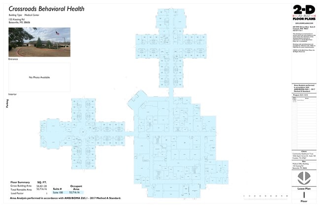
Current Lease Availabilities
Property Detail
155 Keating Rd
3182P0005300-40002600
12.7 AC PT SE 1/4 SE 1/4 - UNPLATTED LAND 9-9-7
Hospitalpublic
Panola
B and X Area of moderate flood hazard, usually the area between the limits of the 100-year and 500-year floods.
Mississippi
2025
12.70 AC
2025
Tupelo/North Area
950601
Other Market Areas
42,389 SF
NEARBY LISTINGS FOR SALE OR LEASE
-
-
View all Batesville listings for lease on LoopNet.com
DEMOGRAPHICS near 155 Keating Rd
1 mile
3 mile
5 mile
2025 Total Population
1,610
7,503
10,935
2030 Population
1,571
7,349
10,773
Pop Growth 2025-2030
(2.42%)
(2.05%)
(1.48%)
Average Age
41
38
39
2025 Total Households
607
2,776
4,042
HH Growth 2025-2030
(2.64%)
(2.13%)
(1.51%)
Median Household Inc
$77,000
$39,160
$50,642
Avg Household Size
2.50
2.60
2.60
2025 Avg HH Vehicles
2.00
2.00
2.00
Median Home Value
$218,662
$148,106
$150,852
Median Year Built
1987
1982
1984
Nearby Places
Map Layers
Map Styles
 Street
 Aerial
Layers
 Traffic
 Biking
Places
Listings with unknown addresses are not visible on the map
- Restaurants
- Banks
- Shops
- Fitness
- Groceries
Nearby Properties
Address
Land Use
TOTAL SIZE
Lot Size
Zoning
Address
Land Use
TOTAL SIZE
Lot Size
Zoning
138,838 SF
14.30 AC
Address
Land Use
TOTAL SIZE
Lot Size
Zoning
10,000 SF
90.70 AC
Address
Land Use
TOTAL SIZE
Lot Size
Zoning
119,834 SF
23.70 AC
Address
Land Use
TOTAL SIZE
Lot Size
Zoning
9,911 SF
9.80 AC
Address
Land Use
TOTAL SIZE
Lot Size
Zoning
5,802 SF
11.50 AC
Address
Land Use
TOTAL SIZE
Lot Size
Zoning
108,001 SF
13.10 AC
Address
Land Use
TOTAL SIZE
Lot Size
Zoning
4,120 SF
39 AC
Address
Land Use
TOTAL SIZE
Lot Size
Zoning
Address
Land Use
TOTAL SIZE
Lot Size
Zoning
97,155 SF
14.20 AC
Address
Land Use
TOTAL SIZE
Lot Size
Zoning
5,901 SF
7 AC
Address
Land Use
TOTAL SIZE
Lot Size
Zoning
7,492 SF
45.50 AC
Address
Land Use
TOTAL SIZE
Lot Size
Zoning
2.20 AC
Address
Land Use
TOTAL SIZE
Lot Size
Zoning
10,000 SF
26.50 AC
Address
Land Use
TOTAL SIZE
Lot Size
Zoning
49,248 SF
2.40 AC
Address
Land Use
TOTAL SIZE
Lot Size
Zoning
10,530 SF
12 AC
Address
Land Use
TOTAL SIZE
Lot Size
Zoning
41,413 SF
2.80 AC
Address
Land Use
TOTAL SIZE
Lot Size
Zoning
20,172 SF
2.10 AC
Address
Land Use
TOTAL SIZE
Lot Size
Zoning
6,000 SF
8.60 AC
Address
Land Use
TOTAL SIZE
Lot Size
Zoning
50,486 SF
3 AC
Address
Land Use
TOTAL SIZE
Lot Size
Zoning
88,114 SF
10.30 AC
Address
Land Use
TOTAL SIZE
Lot Size
Zoning
29,333 SF
1.80 AC
Address
Land Use
TOTAL SIZE
Lot Size
Zoning
15,086 SF
1.80 AC
Address
Land Use
TOTAL SIZE
Lot Size
Zoning
17,461 SF
1.80 AC
Address
Land Use
TOTAL SIZE
Lot Size
Zoning
27,603 SF
3.80 AC
Address
Land Use
TOTAL SIZE
Lot Size
Zoning
The World's #1 Commercial Real Estate Marketplace
Connect with us
© 2026 CoStar Group
The information above has been obtained from sources believed reliable. While we do not doubt its accuracy we have not verified it and make no guarantee, warranty or representation about it. It is your responsibility to independently confirm its accuracy and completeness. Any projections, opinions, assumptions, or estimates used are for example only and do not represent the current or future performance of the property. The value of this transaction to you depends on tax and other factors which should be evaluated by your tax, financial, and legal advisors. You and your advisors should conduct a careful, independent investigation of the property to determine to your satisfaction the suitability of the property for your needs.