Property Record
155 Main St, Bloomsbury, NJ 08804
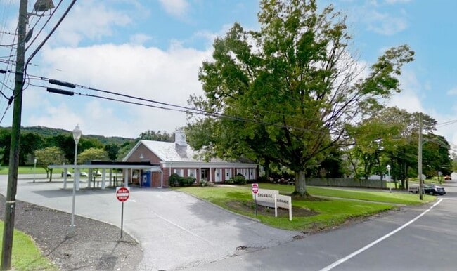

Property Detail
155 Main St
03-00032-0000-00002
Hunterdon
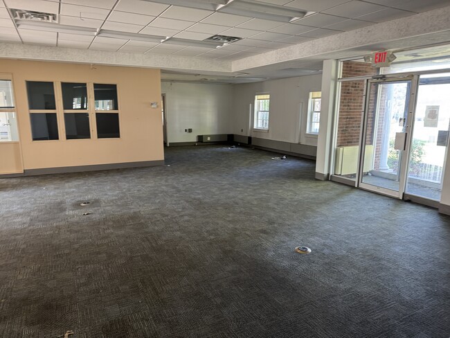
Financialbuilding
New Jersey
B-2
2
B and X Area of moderate flood hazard, usually the area between the limits of the 100-year and 500-year floods.
2.39 AC
2024
Hunterdon
2025
Northern New Jersey
010400
Newark, NJ
3,566 SF
NEARBY LISTINGS FOR SALE OR LEASE
-
-
View all Bloomsbury listings for sale on LoopNet.com
DEMOGRAPHICS near 155 Main St
1 mile
3 mile
5 mile
2025 Total Population
1,055
5,257
23,806
2030 Population
1,068
5,333
24,263
Pop Growth 2025-2030
+ 1.23%
+ 1.45%
+ 1.92%
Average Age
43
44
44
2025 Total Households
429
1,917
8,911
HH Growth 2025-2030
+ 1.17%
+ 1.41%
+ 1.96%
Median Household Inc
$100,223
$145,184
$129,075
Avg Household Size
2.40
2.70
2.60
2025 Avg HH Vehicles
2.00
3.00
2.00
Median Home Value
$368,867
$483,021
$428,342
Median Year Built
1951
1974
1974
Nearby Places
Map Layers
Map Styles
 Street
 Aerial
Layers
 Traffic
 Biking
Places
Listings with unknown addresses are not visible on the map
- Restaurants
- Banks
- Shops
- Fitness
- Groceries
PUBLIC TRANSPORTATION
AIRPORT
Lehigh Valley International
Drive
Walk
Distance
Lehigh Valley International
38 min
23.4 mi
Trenton Mercer
Drive
Walk
Distance
Trenton Mercer
59 min
39.0 mi
Freight Ports
Maher Terminal
Drive
Walk
Distance
Maher Terminal
67 min
53.4 mi
SALE & LEASE HISTORY
LISTING DATE
SALE/LEASE

Aug 07, 2025
For Sale
Apr 23, 2021
For Lease
Nearby Properties
Address
Land Use
TOTAL SIZE
Lot Size
Zoning
Address
Land Use
TOTAL SIZE
Lot Size
Zoning
39.52 AC
ROM
Address
Land Use
TOTAL SIZE
Lot Size
Zoning
9.05 AC
MR
Address
Land Use
TOTAL SIZE
Lot Size
Zoning
185.60 AC
AR
Address
Land Use
TOTAL SIZE
Lot Size
Zoning
12.02 AC
B-2
Address
Land Use
TOTAL SIZE
Lot Size
Zoning
14.29 AC
B-2
Address
Land Use
TOTAL SIZE
Lot Size
Zoning
14.70 AC
MFG
Address
Land Use
TOTAL SIZE
Lot Size
Zoning
13,478 SF
0.98 AC
R-3
Address
Land Use
TOTAL SIZE
Lot Size
Zoning
6,004 SF
5 AC
RC
Address
Land Use
TOTAL SIZE
Lot Size
Zoning
153.13 AC
MR
Address
Land Use
TOTAL SIZE
Lot Size
Zoning
3.77 AC
Address
Land Use
TOTAL SIZE
Lot Size
Zoning
6.04 AC
ROM
Address
Land Use
TOTAL SIZE
Lot Size
Zoning
3,840 SF
3.32 AC
B-2
Address
Land Use
TOTAL SIZE
Lot Size
Zoning
875 SF
0.67 AC
DB
Address
Land Use
TOTAL SIZE
Lot Size
Zoning
2,672 SF
4.52 AC
B-2
Address
Land Use
TOTAL SIZE
Lot Size
Zoning
3,120 SF
7 AC
MR
Address
Land Use
TOTAL SIZE
Lot Size
Zoning
9,979 SF
0.46 AC
R-2
Address
Land Use
TOTAL SIZE
Lot Size
Zoning
97.27 AC
MR
Address
Land Use
TOTAL SIZE
Lot Size
Zoning
0.47 AC
C-1
Address
Land Use
TOTAL SIZE
Lot Size
Zoning
14.01 AC
Address
Land Use
TOTAL SIZE
Lot Size
Zoning
Address
Land Use
TOTAL SIZE
Lot Size
Zoning
8,484 SF
1 AC
RC
Address
Land Use
TOTAL SIZE
Lot Size
Zoning
7,094 SF
1 AC
Address
Land Use
TOTAL SIZE
Lot Size
Zoning
3,954 SF
1 AC
Address
Land Use
TOTAL SIZE
Lot Size
Zoning
640 SF
2.01 AC
GC
Address
Land Use
TOTAL SIZE
Lot Size
Zoning
4,965 SF
2 AC
AR
Address
Land Use
TOTAL SIZE
Lot Size
Zoning
3,544 SF
1 AC
RC
Address
Land Use
TOTAL SIZE
Lot Size
Zoning
5,502 SF
1 AC
MR
Address
Land Use
TOTAL SIZE
Lot Size
Zoning
3.81 AC
A-R
Address
Land Use
TOTAL SIZE
Lot Size
Zoning
4,382 SF
1 AC
ROM
Address
Land Use
TOTAL SIZE
Lot Size
Zoning
107.34 AC
The World's #1 Commercial Real Estate Marketplace
Connect with us
© 2026 CoStar Group
The information above has been obtained from sources believed reliable. While we do not doubt its accuracy we have not verified it and make no guarantee, warranty or representation about it. It is your responsibility to independently confirm its accuracy and completeness. Any projections, opinions, assumptions, or estimates used are for example only and do not represent the current or future performance of the property. The value of this transaction to you depends on tax and other factors which should be evaluated by your tax, financial, and legal advisors. You and your advisors should conduct a careful, independent investigation of the property to determine to your satisfaction the suitability of the property for your needs.