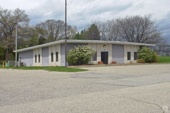
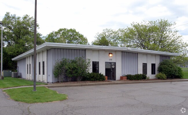
Property Record
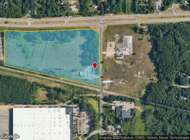
155 Spaulding Ave Se, Ada, MI 49301
NEARBY LISTINGS FOR SALE OR LEASE
Property Detail
155 Spaulding Ave Se
41-15-30-300-018
Grand Rapids
Commercialnec
411530300018 PART OF SWFRL 1/4 COM 331.60 FT S 0D 23M 29S E ALONG N&S 1/4 LINE FROM CEN OF SEC TH N 58D 09M 37S W 202.80 FT
X
Kent
26081C0433D
Michigan
2024
34.84 AC
2025
Ada/Lowell
011902
West Michigan
4,500 SF
Grand Rapids-Wyoming-Kentwood, MI
DEMOGRAPHICS near 155 Spaulding Ave Se
1 mile
3 mile
5 mile
2024 Total Population
4,589
28,677
105,951
2029 Population
4,631
28,991
106,862
Pop Growth 2024-2029
+ 0.92%
+ 1.09%
+ 0.86%
Average Age
39
40
39
2024 Total Households
1,596
9,889
40,144
HH Growth 2024-2029
+ 0.88%
+ 1.19%
+ 0.85%
Median Household Inc
$130,247
$119,010
$95,022
Avg Household Size
2.90
2.70
2.50
2024 Avg HH Vehicles
2.00
2.00
2.00
Median Home Value
$397,417
$396,937
$345,957
Median Year Built
1999
1990
1977
Nearby Places
Map Layers
Map Styles
 Street
 Aerial
Transit
 Traffic
 Biking
Places
Listings with unknown addresses are not visible on the map
- Restaurants
- Banks
- Shops
- Fitness
- Groceries
PUBLIC TRANSPORTATION
COMMUTER RAIL
Drive
Walk
Distance
13 min
9.3 mi
AIRPORT
Gerald R Ford International
Drive
Walk
Distance
Gerald R Ford International
20 min
8.4 mi
Nearby Properties
Address
Land Use
TOTAL SIZE
Lot Size
Zoning
Address
Land Use
TOTAL SIZE
Lot Size
Zoning
277.36 AC
I
Address
Land Use
TOTAL SIZE
Lot Size
Zoning
709,488 SF
106.95 AC
LI
Address
Land Use
TOTAL SIZE
Lot Size
Zoning
126,805 SF
9.36 AC
C4
Address
Land Use
TOTAL SIZE
Lot Size
Zoning
151,708 SF
7.22 AC
C4
Address
Land Use
TOTAL SIZE
Lot Size
Zoning
Address
Land Use
TOTAL SIZE
Lot Size
Zoning
226,877 SF
22.40 AC
R2
Address
Land Use
TOTAL SIZE
Lot Size
Zoning
14,706 SF
11.25 AC
R-1
Address
Land Use
TOTAL SIZE
Lot Size
Zoning
138,278 SF
35.63 AC
R-1
Address
Land Use
TOTAL SIZE
Lot Size
Zoning
32,366 SF
34.78 AC
R-1
Address
Land Use
TOTAL SIZE
Lot Size
Zoning
154,643 SF
10.96 AC
O-PUD
Address
Land Use
TOTAL SIZE
Lot Size
Zoning
183,583 SF
9.12 AC
R-1
Address
Land Use
TOTAL SIZE
Lot Size
Zoning
209,417 SF
19.51 AC
C4
Address
Land Use
TOTAL SIZE
Lot Size
Zoning
18.86 AC
MON-MDR
Address
Land Use
TOTAL SIZE
Lot Size
Zoning
105,029 SF
5.65 AC
C
Address
Land Use
TOTAL SIZE
Lot Size
Zoning
23.01 AC
MON-MDR
Address
Land Use
TOTAL SIZE
Lot Size
Zoning
Address
Land Use
TOTAL SIZE
Lot Size
Zoning
110,706 SF
23.76 AC
C4
Address
Land Use
TOTAL SIZE
Lot Size
Zoning
Address
Land Use
TOTAL SIZE
Lot Size
Zoning
1,144 SF
4.15 AC
PUD
Address
Land Use
TOTAL SIZE
Lot Size
Zoning
86,082 SF
171.94 AC
R-1
Address
Land Use
TOTAL SIZE
Lot Size
Zoning
67,400 SF
6.43 AC
O-PUD
Address
Land Use
TOTAL SIZE
Lot Size
Zoning
83,464 SF
3.28 AC
SD-PRD
Address
Land Use
TOTAL SIZE
Lot Size
Zoning
33,540 SF
5.67 AC
PO
Address
Land Use
TOTAL SIZE
Lot Size
Zoning
42,095 SF
3.87 AC
SR
Address
Land Use
TOTAL SIZE
Lot Size
Zoning
31,736 SF
3.76 AC
C4
Address
Land Use
TOTAL SIZE
Lot Size
Zoning
81,762 SF
9.26 AC
C-PUD
Address
Land Use
TOTAL SIZE
Lot Size
Zoning
79,374 SF
12.20 AC
C-2
Address
Land Use
TOTAL SIZE
Lot Size
Zoning
14,700 SF
1.44 AC
Address
Land Use
TOTAL SIZE
Lot Size
Zoning
81,494 SF
21.36 AC
R-1
Address
Land Use
TOTAL SIZE
Lot Size
Zoning
59,200 SF
7.62 AC
C-1
The World's #1 Commercial Real Estate Marketplace
Connect with us
© 2026 CoStar Group
The information above has been obtained from sources believed reliable. While we do not doubt its accuracy we have not verified it and make no guarantee, warranty or representation about it. It is your responsibility to independently confirm its accuracy and completeness. Any projections, opinions, assumptions, or estimates used are for example only and do not represent the current or future performance of the property. The value of this transaction to you depends on tax and other factors which should be evaluated by your tax, financial, and legal advisors. You and your advisors should conduct a careful, independent investigation of the property to determine to your satisfaction the suitability of the property for your needs.